 |
Deutsche Version (English version below): |
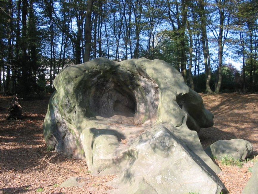
Bei diesem eindrucksvollen und imposanten Gebilde handelt es
sich um einen Tertiärquarzit, der früher vollständig von
Sandschichten umschlossen war. Die Sande wurden an der Wende vom
Oligozän zum Miozän von großen Flusssystemen abgelagert. Da der
Quarzsand nach oben hin für einen Luftabschluss gesorgt hat, konnte
das organische Material nicht zersetzt werden und wurde zu
Braunkohle. Diese spezielle Schichtfolge wird als Kölner Schichten
bezeichnet. Im Tertiär herrschte ein subtropisches Klima mit hohen
Durchschnittstemperaturen und hohen Niederschlägen. Dieses Klima
löste in den oberen Schichten chemische Prozesse aus, in deren
Verlauf die Quarzkörner - aus denen die Sande bestehen - durch
Kieselsäure zu einem festen Gestein verkittet wurden. Dieser
Prozess wird auch als Zementierung bezeichnet.
Zum Vergrößern bitte Anklicken
Der Hohlstein
Um
diesen Earthcache zu loggen, erfülle bitte folgende
Aufgaben:
- Schreibe mir eine E-Mail mit den Antworten auf nachfolgende
Fragen (Du brauchst nicht auf eine Logfreigabe zu warten, ich
melde mich, wenn etwas nicht stimmt):
- Welche Maße hat der Hohlstein (Länge, Breite und
Höhe)?
- Vor wie vielen Jahren war die Aushöhlung des Steins
beendet?
- Wann vollzog sich das Freischwemmen durch den
Urrhein?
- Mache bitte freiwillig ein Foto von dir vor dem Hohlstein.
Falls du alleine bist, reicht auch ein Foto von deinem GPS mit
lesbaren Koordinaten. BITTE MACHE KEIN FOTO VON DER
INFORMATIONSTAFEL!
Empfehlung:
Dieser Cache läßt sich super mit einem "Klassiker" verbinden!
Troisville
 |
English version: |
Please contact me before you drive to this
earthcache, if you are not able to read
german!
The hollow rock, you can find at the above coordinates, is a
quartzite (formed during the tertiary). Former the rock was
enclosed by different sand layers. This layers were deposited
during the oligocene and the miocene.
click for enlargement
The hollow rock
The hollow rock lies on the lower terrace. You can see the
changeover to the middle terrace behind the rock. Today the rock is
located in a residential area. Next to the rock you can find a huge
information panel with lots of information about the history and
the background of the rock.
To
log this earthcache, perform the following
tasks:
- Write me an email with the following
information:
- What are the measures of the rock (length, width and
height)?
- How many years ago did the erosion of the rock
stop?
- When was the rock released by the
"Urrhein"?
- Please take optional a photo of you in front of the hollow
rock. If you are there without any help, you can take a photo of
your GPSr with readable coordinates instead. PLEASE DO NOT TAKE A
PHOTO OF THE INFORMATION PANEL!
