
This Waymark Falls within Great Falls
National Park (Virginia), Entrance to the park is 5 dollars per car
including a 3 day pass.
Geology of Great Falls:
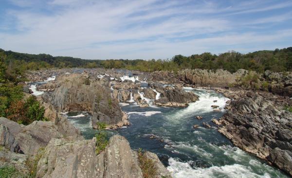
The geologic history of the falls is an interesting one. After the
last ice age, the ocean levels dropped forcing the Potomac river to
carve deeper in its path to the sea. The overlying rock was eroded
away exposing a much harder, resistant rock formation called the
Piedmont. This hard layer is principally made up of highly
metamorphic and igneous rock, and may be seen throughout the park.
For thousands of years the Potomac river has eroded the bedrock,
causing the falls to recede upstream from a point 9 miles
downstream near Chain Bridge to its current position at Great
Falls. Joint fault plains, natural fissures in the rock substrata
where shifting has occurred, exist in many places in the Piedmont
Formation between Chain Bridge and the Great Falls. These areas of
faulting have loosened the rock, forming areas of weakness. The
force of the river has eroded along these areas changing the
river's course to its current position. As one walks along the
cliff tops, evidence of the ancient river beds can be seen in
well-rounded boulders, smoothed surfaces and grooves, and
beautifully formed potholes which were once formed on the ancient
riverbed. The metamorphic rocks provide jagged rocky surfaces and
high-walled cliffs, stark and pristine against the crashing waters
of the Potomac at the falls and along Mather Gorge.
To Claim this cache you will have to go to
the points below and complete each task.
Visitor Center: N 38° 59.812 W 077° 15.285
Slideshow:
1. How many years ago did humans start using the
Falls?
2. Who ventured here in 1608?
3. The Earliest use of _________ in the US occured here.
Visitor Center Display:
1. What 5 rocks are on display
here?
Life Under the Surface: N 38° 59.794 W 077° 15.217
1. What 3 things impacted this
region?
Globally Rare Enviroment: N 38° 59.714 W 077° 15.179
1. What does the yellow indicate?
2. Take a photo of you and your group with GPS here with the falls
behind you.
River of Change: N 38° 59.714 W 077° 15.179
1. Where does it start?
2. How far does it drop?
Why is there a Hole in That Rock?: N 38° 59.579 W 077°
14.964
1. How long did scientist estimate?
2. Find another pothole along the trail and take a photo of it and
your GPS.
Life on the Edge: N 38° 59.441 W 077° 14.908
1. Photo 3: What provides a stabe home?
2. what thrives in the rocky soils?
If you are Handicapped, i.e. wheelchair or
crutches then you only need to answer the questions in blue. This
is so everyone can enjoy a part of this park.
Geology Map of the Great Falls region
