

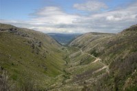
The Zêzere River valley
 The Zêzere River is one of the most important tributaries of the Tagus River that eventually opens out and meets the Atlantic Ocean in Lisbon. It's source is located high up in the mountains of the Massif Central of Portugal.
The Zêzere glacial valley, fed by the ample cirques of "Covão da Ametade, Candeeira and Covões" originated the most extensive ice sheet of the Estrela Mountain Range which, is believed to have  reached some 13 km in length and a maximum altitude of 680m. The last glacier is believed to have occurred as early as 20000 years ago.
The chief characteristic of any glacial valley is the fact that they, as a result of the scouring action of the ice together with included rock debris, form U-shaped valleys (see photos) rather that the V-shaped valleys of regular rivers. The Zêzere Valley in the manteigas region of the Estrela Mountain range provides an excellent platform for viewing this feature.
Glaciers
Glaciers can be characterised in three types: 1- Valley, or mountain, glaciers; are tongues of moving ice sent out by mountain snowfields following valleys originally formed by streams; 2- Piedmont glaciers, which occur only in high latitudes, are formed by the spreading of valley glaciers where they emerge from their valleys or by the confluence of several valley glaciers; 3- Continental glaciers are huge ice sheets whose margins may break off to form icebergs.
A glacier is a dynamic system of ice and water, which. interacts with the atmosphere by accumulating snow which over lengthy periods of time and successive freezing and thawing, converts that snow to firn producing a fluid field of ice.
Glaciers are mighty sculpters of the landscape. Glaciers alter topography, and their work includes erosion, transportation, and deposition. They transform V-shaped valleys into U-shaped valleys by grinding away the projecting bases of slopes and cliffs and leveling the floors of the valleys. A  glacier moves as a solid rather than as a liquid, as is indicated by the formation of crevasses. The center of a glacier moves more rapidly than the sides and the surface more rapidly than the bottom, because the sides and bottom are held back by friction. The rate of flow depends largely on the volume of ice in movement, the slope of the ground over which it is moving, the slope of the upper surface of the ice, the amount of water the ice contains, the amount of debris it carries, the temperature, and the friction it encounters.
Mean speeds of glacier movement vary. Some move very slowly but others can move as fast as many meters per day. A case in point is the Byrd Glacier, an outlet glacier in Antarctica which moves 750-800 meters per year (approximately 2 meters per day). Many glaciers have periods of very rapid advancement called surges. These glaciers exhibit normal movement until suddenly they accelerate, then return to their previous state. During these surges, the glacier may reach velocities up to 1000 times greater than normal.
The scouring action of glaciers
There are two processes that glaciers use to do this seemingly impossible task. First, water gets  into the cracks and joints of bedrock over which glaciers flow, then freezes. As water freezes, it expands and loosens the rock(s). Then a glacier can pick up the rocks and carry them away in a process known as glacial plucking.
Secondly, glaciers can serve as sandpaper and chisels. Sediment and rock frozen to the bottom and sides of glaciers scour, grind, and scrape the rock surfaces over which they flow, gradually wearing them down and away. This abrasion  of rock against rock can scour the landscape and leave large gouges, small striations, or even a finely polished surface. In the end, the sediment the glacier uses to abrade the surface may be ground so fine it becomes glacial flour.
Ice behaves like an easily breaking solid until its thickness exceeds about 50 meters. The increased pressure on ice deeper than that depth causes the ice to become plastic and flow. The glacial ice is made up of layers of molecules stacked on top of each other, with relatively weak bonds between the layers. When the stress of the layer above exceeds the inter-layer binding strength, it moves faster than the layer below.
Another type of movement is basal sliding. In this process, the whole glacier moves over the terrain on which it sits, lubricated by meltwater. As the pressure increases toward the base of the glacier, the melting point of water decreases, and the ice melts. Friction between ice and rock and geothermal heat from the Earth's interior also contribute to thawing. This type of movement is dominant in temperate glaciers. The geothermal heat flux becomes more important the thicker a glacier becomes.
Claiming the earthcache
There are plenty of locations to see this glacial valley. A good lookout point is the cache coordinates given near the Pousada de S. Lourenço. However, excellent views are possible all along the road leading from Manteigas to Covão D'ametade. To claim this cache you have to: 1- near the cache coordinates is an information panel with aspects of the glaciation and location names. Read the information panel and send me an e-mail with the full sentence that starts "No máximo da glaciação .........................periféricos" (do not post the answers in your log) and 2- (OPTIONAL) Insert a nice picture of yourself enjoying this fantastic glacial valley in the log (OPTIONAL)!

Geologia da Serra da Estrela
A Serra da Estrela é um maciço montanhoso culminante de Portugal e constitui a parte oriental de um alinhamento, que se estende cerca de 115 Km,  desde a região da Guarda até ao maciço da Lousã (Galopim de Carvalho et al., 1990).
A Serra da Estrela é constituída por planaltos alongados na direcção SW-NE. As altitudes mais elevadas encontram-se do lado Sudoeste, no chamado Planalto da Torre, onde se atinge a maior altitude de Portugal continental, a 1993 metros. As altitudes vão diminuindo gradualmente para Noroeste, até que, por alturas da Guarda, a montanha quase se confunde com os planaltos da Beira Transmontana. Isto significa que a Serra da Estrela é sobretudo imponente do lado Sudoeste, levantando-se dos planaltos e depressões circunstantes por vertentes de várias centenas de metros de altura (Ferreira & Vieira, 1999).
Este dispositivo geral da topografia é devido, essencialmente, a deslocações tectónicas, que levantaram a montanha dos planaltos envolventes e a balançaram para Nordeste. As escarpas que a limitam são escarpas de falha, com uma evolução relativamente longa, que devem ter dado origem à actual Serra da Estrela há, pelo menos, 200 milhões de anos (Ferreira & Vieira, 1999).
 No entanto, os grandes desníveis que se observam na Serra da Estrela não são devidos, apenas, a deslocações tectónicas. Eles devem-se, em grande medida, aos profundos entalhes dos rios, induzidos pelo próprio levantamento da montanha, a partir dos planaltos marginais. Por sua vez, as falhas que cindem o interior da montanha são tamb
 ém responsáveis pelos entalhes fluviais mais profundos, pois o esmagamento tectónico das rochas facilitou o encaixe dos rios. Exemplo disso é o majestoso Vale do Zêzere, a montante de Manteigas. Isto significa que, na formação das linhas gerais do relevo da Serra da Estrela, houve uma interacção permanente entre a tectónica e a erosão fluvial (Brigas, 1992).
Mas, se descermos algumas dezenas ou centenas de metros apenas, as formas de terreno que observamos a cada passo podem ter origens bem diversas. Umas dependem da natureza das rochas, nomeadamente das rochas graníticas, outras estão relacionadas com climas muito mais frios que o actual, que ocorreram no Quaternário recente, particularmente à cerca de 20 000 anos, em que a temperatura atmosférica desceu pelo menos 10º C e a parte mais alta da Serra da Estrela ficou coberta por glaciares (Galopim de Carvalho et al., 1990).
Como se formou a Serra da Estrela?
Podemos, de uma forma sintética, iniciar a história de formação da Serra da Estrela retrocedendo a um período, que remonta a 650 milhões de anos, no Precâmbrico. Em meio marinho, foram acumulando-se sedimentos terrígenos, resultantes  da erosão de continentes então existentes. Este empilhamento de material sedimentar estendeu-se até ao Câmbrico médio-superior, acerca de 500 milhões de anos, atingindo uma espessura estimada em alguns quilómetros. Esses sedimentos, que apresentam características de bacias sedimentares profundas, foram depositando-se em camadas alternadas de sedimentos argilosos muito finos e sedimentos de composição arenosa fina e argilosa que, por diagénese e metamorfismo, deram origem, respectivamente, às rochas xistentas e aos grauvaques, formando o Complexo Xistograuváquico (Ferreira & Vieira, 1999).
No Devónico médio, há 380 milhões de anos, inicia-se uma fase de movimentos compressivos, designada por Fase 1, que inicia a Orogenia Hercínica, durando até ao final deste período, há 360 milhões de anos. Esta força compressiva afectou os sedimentos marinhos depositados anteriormente, provocando dobras de plano axial subvertical, com orientação NO-SE (Ferreira & Vieira, 1999).
Durante o Carbónico, há 330 milhões de anos, uma nova fase compressiva, Fase 3, origina novos dobramentos com a mesma orientação da Fase 1, instalando-se, simultaneamente e em profundidade, a grande massa de granitos. Estes não se instalam num único impulso, mas ao longo de um período relativamente longo, que se inicia aos 320 e se prolonga até aos 290 milhões de anos. O final da Orogenia Hercínica, há 240 milhões de anos, é marcada pela fracturação das rochas formadas, com direcção NNE-SSW a ENE-WSW e NNW-SSE a NW-SE (Ferreira & Vieira, 1999).
Um período de tempo relativamente longo decorre então. Por erosão dos níveis superiores da crosta, esta, por alívio de carga, vai subindo, trazendo de níveis mais profundos até à superfície, as rochas aí formadas. Este período, que decorreu durante o Mesozóico, provocou o arrasamento geral do relevo e  deu origem a uma superfície aplanada, que se estendia pela Península Ibérica (Galopim de Carvalho et al., 1980).
No início do Terciário, novas forças de compressão, desta vez relacionadas com os movimentos alpinos, vão provocar o rejogo das antigas falhas hercínicas, que passam de falhas de desligamento a falhas inversas.
No Miocénico superior, há 10 milhões de anos, iniciam-se os primeiros movimentos de subida dos blocos que formam a serra, que se continuou por impulsos sucessivos até ao último, que terá ocorrido há cerca de 2 milhões de anos e que marcou a sua estrutura actual. Este fenómeno deu origem à elevação da montanha, por movimento em sistemas de falhas paralelas, o que originou blocos diferencialmente desnivelados, provocando o efeito de escadaria com que a Serra da Estrela se apresenta. A actividade tectónica, contudo, não se extinguiu, existindo, ainda hoje, actividade neotectónica, com movimentos ao longo das grandes falhas, como provam a ocorrência de nascentes termais e de sismos, frequentes na região (Ferreira & Vieira, 1999).
No Quaternário, há registo de várias grandes glaciações, a última das quais terá atingido a  Serra da Estrela à cerca de 20 000 anos, com o estabelecimento de neves permanentes e de glaciares. Estes glaciares deixaram testemunhos geomorfológicos únicos em Portugal e constituem, sem dúvida, a maior originalidade da paisagem física da Serra da Estrela (Ferreira & Vieira, 1999).
A glaciação da Serra da Estrela permitiu a existência de neves perpétuas, a partir dos 1650 metros. Isso significa que, a partir dessa altitude, as neves não fundiam de um ano para o outro, permitindo, assim, a sua compactação, dando origem ao nevado e, por fim, ao gelo. Do ponto de vista da temperatura, o nível das neves perpétuas significa uma altitude, a partir da qual a temperatura atmosférica média mensal é sempre negativa. Comparando essa situação com as temperaturas actuais, é fácil deduzir que as temperaturas eram cerca de 10º C mais baixas que actualmente (Ferreira & Vieira, 1999).
 A cúpula de gelo de planalto ocupava uma superfície de 70 km2 e uma espessura que não deveria ultrapassar os 80 metros. Pelo contrário, a espessura dos gelos, nos vales, poderia ser consideravelmente maior: por exemplo, as moreias da lagoa seca permitem afirmar que a língua glaciária do Zêzere atingia 300 metros de espessura (Ferreira & Vieira, 1999).
Na Serra da Estrela, de uma forma geral, podemos distinguir 5 vales glaciários: o Vale Glaciar do Zêzere, o do Covão do Urso, o do Covão Grande, o da Loriga e o da Alforfa.
O Vale Glaciar do Zêzere, alimentado pelos amplos circos do Covão da Ametade, da Candeeira e dos Covões, originou a mais extensa língua glaciária da Serra da Estrela, a qual terá atingido 13 km de comprimento e a altitude mínima de 680 metros (Daveau, 1971).
No que diz respeito à geologia, a Serra da Estrela é dominada pela ocorrência de rochas graníticas hercínicas, com composição variada, desde os granodioritos aos leucogranitos, de idade compreendida entre os 340 e os 280 milhões de anos. Estas intruem metassedimentos de idade Precâmbrica - Câmbrica, entre os 500 - 650 milhões de anos, relativos ao Complexo Xistograuváquico (Brigas, 1992), que representam, assim, os depósitos sedimentares mais antigos desta região (Galopim de Carvalho et al., 1990).
Além destes dois tipos de formações principais (Complexo Xistograuváquico e granitos), destacam-se, ainda, formações cenozóicas: aluviões, depósitos de vertente, terraços fluviais, depósitos fluvio-glaciários e glaciários (Ferreira & Vieira, 1999). Source.
A earthcache
Para poderem fazer o found desta earthcache, dirijam-se às coordenadas indicadas. Neste ponto existe um miradouro com uma vista fabulosa sobre o Vale Glaciar do Zêzere. Neste miradouro, há um painel informativo com uma breve resanha da sua formação. Neste painel estão indicadas diversos factos sobre a glaciação no Vale do Zêzere. Quero que me digam a frase completa que começa "No máximo da glaciação ..........períféricosl" Enviem-me as respostas por mail e não coloquem as respostas no log. Já agora aproveitem para incluir no vosso log uma foto engraçada de voçês a divirtirem-se nas redondezas deste vale. A foto é opcional.

 The most exciting way to learn about the Earth and its processes is to get into the outdoors and experience it first-hand. Visiting an Earthcache is a great outdoor activity the whole family can enjoy.
An Earthcache is a special place that people can visit to learn about a unique geoscience feature or aspect of our Earth. Earthcaches include a set of educational notes and the details about where to find the location (latitude and longitude). Visitors to Earthcaches can see how our planet has been shaped by geological processes, how we manage the resources and how scientists gather evidence to learn about the Earth. To find out more click HERE.