
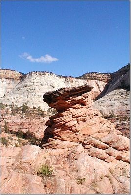
 Hoodos:
These rock formations are called hoodos. As you can see, these free-standing towers of rock are capped with a dark brown to black layer. These layers are more resistant to erosion, so they protect the sandstone underneath like a helmet as the surrounding sandstone is eroded away.
These hard layers are thought to be secondary enrichment (occuring after the rock originally formed)of the cement that holds the sand grains of the sandstone together. Groundwater migrating down through the microscopic spaces between the sand grains of the sandstone dissolve a small amount of the sandstone’s cementing material. The groundwater transports that cement to another location in the rock. As the groundwater collects and flows along layers of the rock, the cementing material is then redeposited forming a layer of harder material.
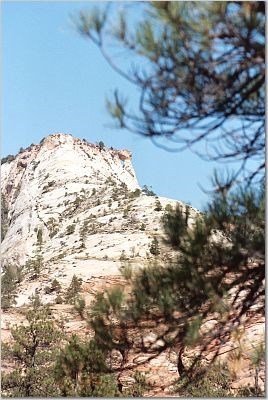 Jug Arch View N 37 13.590 W 112.54.146
(These are coordinates to see the arch about a mile away to the north. The arch can actually be seen from the road if the climb looks to treacherous)
As you look up the canyon to the north you can see the jug arch on the east side of the tallest mountain. The jug arch name comes from the orientation of the arch; it is attached to the mountain like the handle of a mug or jug.
In the picture to the right, the arch can be picked out on the right side of the mountain just below the pine branches. The hole at this distance is about the size of a pencil lead.
The formation of free-standing arches are complex and not completely understood. In this case it is thought that expansion joints helped form this arch. Expansion joints are cracks that form in the rock as the pressure from being buried is released. These joints typically parallel and form at relatively regular intervals throughout a rock formation.
Erosion preferentially occurs along these cracks and enlarges them. To form the arch, erosion takes advantage of some form of internal weakness in the middle of the rock and erodes out the center of the arch.
Small Slot Canyon N 37 13.552 W 112 54.190
At this location you will find a steep and narrow canyon the winds its way through the Navajo Sandstone. This canyon formed with these sheer walls because the downward erosional force cut through the sandstone much faster than the lateral (sideways) erosion. The sandstone has enough internal strength to hold itself up and thus maintains the sheer walls.
Logging requirements:
Send me a note with :
- The text "GCZ5YT East Zion Erosion Features" on the first line
- The number of people in your group.
- What are your ideas on why the slot canyon is shaped as it is?!
The above information was compiled from the following sources:
- Higgins, Janice M. Geology of Snow Canyon State Park, Utah in Geology of Utah’s Parks and Monuments, 2003 Utah Geological Association Publication 28 (second edition) D.A. Sprinkel, T.C. Chidsey, Jr. and P.B. Anderson, editors Miek, Robert F., et. al.,
- Geology of Zion National Park, Utah in Geology of Utah’s Parks and Monuments, 2003 Utah Geological Association Publication 28 (second edition) D.A. Sprinkel, T.C. Chidsey, Jr. and P.B. Anderson, editors
Placement approved by the
Zion National Park