Known to Dakota people as Oheyawahi, “the hill much visited,”
Pilot Knob is a place of distinctive historical, cultural, and
environmental importance, a sacred site, a landmark of Minnesota's
beginnings. Pilot Knob is located on the east end of the Mendota
Bridge, south of Highway 55 in Mendota Heights, Minnesota.
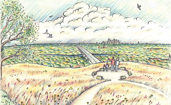
Illustration by Dan Shaw
Overlooking the confluence of the Mississippi and Minnesota
rivers, Pilot Knob offers striking views of the downtown
Minneapolis skyline, Fort Snelling State Park, the Mendota Bridge,
and the Minneapolis/St. Paul International Airport, which has made
it a prime candidate for development in the past. Three years ago,
a private developer announced plans to build high-density housing
on approximately 27 acres of the historic hill. Following strong
objections from Dakota Indian communities, hundreds of area
residents joined historic Native American, religious, and
environmental organizations in urging further study of the site and
establishment of a public reserve.
In December 2005, The Trust for Public Land (TPL) announced that
part of the well-known scenic overlook in Mendota Heights will be
protected as a public natural area. The land conservation
organization purchased the 8.5-acre site at Pilot Knob and sold it
to the City of Mendota Heights.
As public land, the 8.5-acre portion of Pilot Knob will largely
remain in its natural state. The City plans to restore native
vegetation and construct a series of unpaved paths and an
observation area. Once completed, this land will also be accessible
to the public from the adjacent Big Rivers Regional Trail.
Please Note - The beauty of this
cache is the view from Pilot Knob Road. I would encourage you to
park at the end of Pilot Knob and take in the view. It's an easy
walk to the cache from the posted parking waypoint. No bushwacking
is required from this location.
You may be tempted to access this cache from Highway 55, but I
would discourage you from trying that. You can also access the
cache from Highway 13 (west of the cache location). However, the
terrain level is much higher from that approach and bushwacking
will be required.
Cache container: Depending on your perspective, this
is either a large micro or a tiny small. You are looking for a
1"x4" camoed pill bottle. There is enough room for the logbook and
micro or rectangular geocoins.
Please secure the cache container as well or better than you
found it. For best results, bring your own pencil/pen.