City of Fairfax Walking Tour
"Courting History"
This multi-stage cache will take you on a 3 mile walking tour of Historic Old Town Fairfax, Virginia, where you will collect clues and ultimately find a cache upon completing the curcuit. The coordinates listed above designate the suggested parking area for the tour. The coordinates for the first stop on the tour are listed below.
As you visit each stop on the tour, you will need to solve a couple of simple book ciphers using the "Old Town Fairfax" historic markers located at each stop (excluding the optional stops) as the key text. Contained in the description of each stop on the tour is a sequence of numbers that constitute the cipher. The first number of the cipher denotes the line of text, the second number denotes the word in the line, and the last number indicates the letter of the word.
For example, if the book cipher key text is:
    The Fairfax Elementary School was erected in 1873 for the then
    considered exorbitant cost of $2,750. This building is the oldest
    two-story brick public school house in Fairfax County. Its bricks....
and the cipher is 3 - 2 - 1, then the decoded letter would be "S".
You will be solving two (A and B) simultaneous ciphers, which will ultimately provide coordinates for the cache location. As you visit each stop, decode the letters. Once all the letters have been collected, use them to complete the coordinates listed at stop #17 to find the cache.
You can use the table below to record your deciphered letters and figure out the final coordinates.
| Cipher |
#1 |
#3 |
#4 |
#5 |
#6 |
#7 |
#8 |
#9 |
#10 |
#13 |
#14 |
#15 |
| A |
|
|
-- |
|
|
|
|
-- |
|
|
-- |
|
| B |
|
|
|
-- |
|
|
-- |
|
|
-- |
|
|
A few notes about the tour:
- Please be very careful crossing the streets. Many of the streets you will cross and traverse are wide and very busy. Use the crosswalks and cross safely.
- Please respect stops that are private residences, businesses or not open to the public. Many of the historic sites you will visit are existing buildings and structures that have been preserved, renovated and adapted for modern use, or are undergoing preservation. Please respect the status of each stop.
- If you have any questions about what you see today, or want more details about the historic events and locations in the City of Fairfax, please visit the Fairfax Museum & Visitor Center at 10209 Main Street. (Coincidentally, this is the first and last stop on the tour!)
- Finally, have fun! This is an easy, all-season cache and I think you will be surprised and impressed with the history that has unfolded right here in this city.
A Brief History of the City of Fairfax
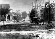
In the late 1700s, the modern day City of Fairfax was nothing more than a remote crossroads, home only to Caleb Earp's general store. However, following the Revolutionary War, Fairfax County's rural inhabitants found the county court's Alexandria location too far removed. On their behalf, George Mason petitioned the Virginia General Assembly in 1790 to relocate the County Court to "such place as should be found most convenient, near the center of the County." Alexandrians naturally opposed the move.
The argument was finally settled when Alexandria was ceded to Congress as part of the new Federal Capital on the Potomac. In 1799, the Virginia General Assembly relocated the court to a crossroads near the county's geographic center--known as Earp's Corner. The county purchased the 4-acre courthouse grounds from Richard Ratcliffe, for the sum of $1.
The courthouse was completed in 1800, and in 1805 the new county seat was established as the Town of Providence (another nearby town had already claimed the name Fairfax). However, throughout the 1800s the area was commonly referred to as "Fairfax Court House." The identity crisis was resolved when the other town abandoned the name, and in 1892 Providence officially became the Town of Fairfax. In 1961, the community once more changed its status, becoming the independent City of Fairfax.
Though covering only six square blocks, the Historic district has covered considerable ground in American history. The colonial courthouse, where George and Martha Washington's wills were probated and remain, has served as the center of Fairfax County for nearly 200 years. And, its proximity to the Federal Capital placed the City of Fairfax (then Providence) in the middle of a divided nation throughout the Civil War.
On June 1, 1861, the first heavy engagement of the war occurred on Main Street when Union cavalry rode into town, firing wildly. As Confederate Captain John Quincy Marr rallied his men, a spent Minnie ball struck him in the chest. Killed by the impact, Marr became the first Confederate officer killed in the bloody war. He died without shedding a drop of blood.
Seven weeks later, Washingtonians in picnic-attire stopped here on their casual outing to the Battle of First Manassas. (However, few so much as broke stride on their rather chaotic return.)
Following the victory at first Manassas, President Jefferson Davis conferred with his generals at the town's Willcoxon Tavern on October 1, 1861. It is believed that this is where General Beauregard redesigned the Confederate battle flag to avoid the confusion and casualties caused by its similarity to the Union flag.
On March 9, 1863, Confederate Ranger John S. Mosby and 29 men entered the Union encampment here and captured Union General Stoughton, while he slept in the Gunnell House. In addition, Mosby captured 2 captains, 30 privates, and 58 horses. (Hearing of the generals' capture, President Lincoln remarked, "I don't care so much about the loss of at he general, as I can make another with the stoke of a pen…but I sure hate to lose those horses.")
Throughout the war, Fairfax resident Antonia Ford impressed soldiers from North and South with her beauty, charm and conversation. Impressed with the ability to recall those conversations, Jeb Stuart awarded her a written commission as "my honorary aide de-camp." Following Mosby's raid, Union officials searched Antonia's house and found the commission. Antonia was imprisoned as a Confederate spy. Fortunately, Miss Ford had also stolen the heart of union Major Joseph C. Willard (owner of the famed Willard Hotel in Washington, DC). After spending 7 months in the Old Capitol Prison, Willard secured her release and they were married.
In 1900, their son gave the townspeople the impressive white colonnaded "Old Town Hall" building, which stands on the corner of University Drive and Main Street.
-- "Six Blocks of Time in American History", from the
"Courting History: A Walking Tour of Old Town Fairfax, Virginia" brochure
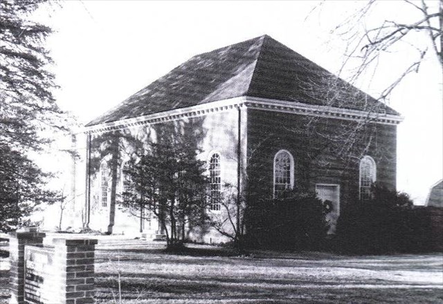
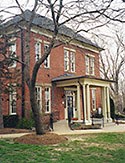
| STOP #1 |
Historic Fairfax Elementary School (Museum) |
| Coordinates |
N38 50.682 W077 18.030 |
Cipher A
Cipher B |
1-9-1, The letter is ___
3-1-3, The letter is ___ |
 |
The Fairfax Elementary School was erected in 1873 for the then considered exorbitant cost of $2,750. This building is the oldest two-story brick public school house in Fairfax County. Its bricks were made from a clay pit on the Farr property across Main Street. The front (T-section) was added in 1912. The building served proudly as the area's principle school until 1925, when the "new school" was opened next door.
The building currently serves as the Fairfax Museum & Visitor Center, open to public, 9AM - 5PM daily. If the museum is open, please pay them a visit; it's a great way to start your tour. Be sure to sign their guest book, enter "Geocaching" in the comments section and tell the docent you are Geocaching.
|
|
Notes:
As you leave the first stop, travel west along Main St. to the crosswalk and light. Cross at the light and travel East along Main St. to the second stop on the tour.
|
| STOP #2 |
Farr Homeplace (Private residence) |
| Coordinates |
N38 50.694 W077 17.978 |
Cipher A
Cipher B |
No clue at this stop.
No clue at this stop. |
 |
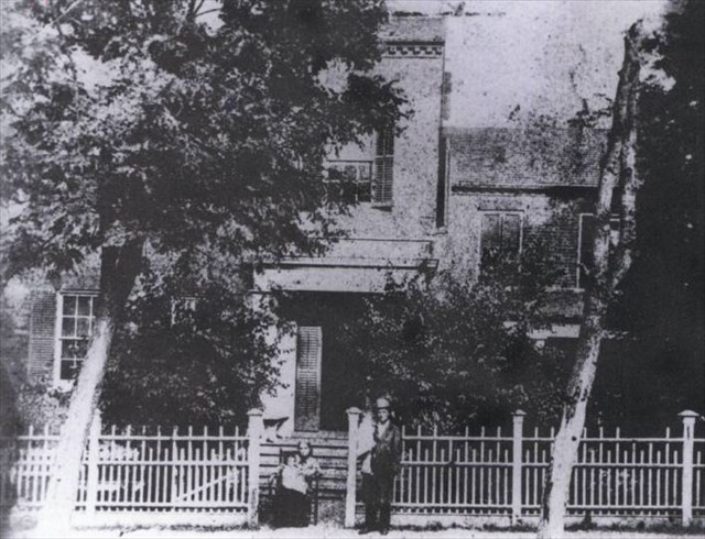
Union soldiers burned the original Farr homeplace after they were fired upon by young Richard Ratcliffe Farr. Upon his return from the war, Farr first built Grandma's Cottage (Now located on the Blenheim property and not yet open to the public) for his mother, then this home, using bricks made from a clay pit on the property. Each of the home's five baroque chimneys has a cross worked into the design. Farr's sons, Wilson and Rezin, both taught at the old Fairfax Elementary School (stop #1). Wilson later served as Virginia's Commonwealth Attorney. |
|
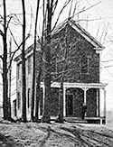
| STOP #3 |
Draper House (Business) |
| Coordinates |
N38 50.747 W077 18.253 |
Cipher A
Cipher B |
2-6-1, The letter is ___
2-3-1, The letter is ___ |
 |
Built by Dr. Samuel Draper, this house served as his home, office, and examining room. Its Flemish bond brickwork, box-like appearance and large end chimneys are typical of Federal style architecture. Many of the structure's original out-buildings have been converted into shops. |
|
| STOP #4 |
Ratcliffe-Allison House (Open by appointment) |
| Coordinates |
N38 50.755 W077 18.285 |
Cipher A
Cipher B |
No clue here.
3-1-1, The letter is ___ |
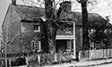 |
This structure is the oldest house in the City. The eastern portion was built by Richard Ratcliffe in 1812 to specifications of the original lot sales in the Town of Providence (which became the Fairfax in 1875), "at least 16-feet square with a brick or stone chimney." For more information or to make a tour reservation, call: 703-385-8414. |
|
| STOP #5 |
Old Town Hall (Open to the public) |
| Coordinates |
N38 50.766 W077 18.310 |
Cipher A
Cipher B |
1-8-3, The letter is ___
No clue here. |
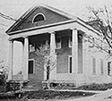 |
Joseph E. Willard, who served as lieutenant governor of Virginia and minister to Spain, financed the construction of Old Town Hall and gave it to the town in 1900. He was said to have been the most influential political figure in Fairfax County at the turn of the century. He was the only child of the Confederate spy, Antonia Ford and Joseph C. Willard, a Union major, and co-owner of the famed hotel in Washington D.C. A renovation of the hall by the City and Historic Fairfax City, Inc. was completed in 1987. Second floor renovations began in 1995 and are now complete. In 1911, many residents saw their first motion picture here (the admission price was 10 cents). |
|
| STOP #6 |
Fairfax Herald and Print Shop (Business) |
| Coordinates |
N38 50.766 W077 18.322 |
Cipher A
Cipher B |
1-5-1, The letter is ___
3-6-2, The letter is ___ |
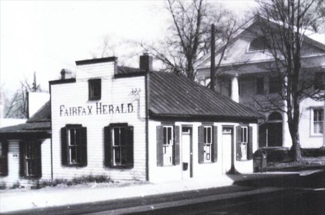 |
The Fairfax Herald was established in 1882 by Capt. S.R. Donohoe who moved it to this small one story structure (built c. 1900) in 1904. The Herald remained in operation until 1966. The Smithsonian Museum of American History purchased the original 1880s printing equipment and displayed it for many years. |
|
| STOP #7 |
Vernacular Buildings (Business) |
| Coordinates |
N38 50.772 W077 18.356 |
Cipher A
Cipher B |
3-4-4, The letter is ___
1-2-1, The letter is ___ |
 |
These three commercial buildings are examples of construction types common at the turn of the 20th century.
- Fairfax Hay & Grain Store, built 1900 (10416 Main street)
- Nichol's Hardware Store, built 1895 (10414 Main street)
- Ralston's Store, built 1895 (10412 Main Street)
|
|
Notes:
The Nichol's Hardware Store is under renovation and the historic marker has been removed. I think the cipher is simple enough to figure out without this clue, but if you must know, A=N, and B=E.
Use the historic marker attached to the Nichol's Hardware Store (now T. T. Reynolds') for the book cipher.
|
| STOP #8 |
Ford Building (Office Building) |
| Coordinates |
N38 50.807 W077 18.379 |
Cipher A
Cipher B |
1-7-1, The letter is ___
No clue here. |
 |
This was the home of Antonia Ford, imprisoned as a spy following Ranger Mosby's night capture of the local Union commander, Brig. Gen. Edwin H. Stoughton, March 9, 1863 (stop #10). A search of the house had revealed an honorary aide-de-camp commission to Antonia from Gen. Jeb Stuart. Union Maj. Willard, a former Provost Marshal at Fairfax Court House, fell in love with Antonia, secured her release and married her. |
|
Notes:
The Ford Building contains the Antonia Ford Museum. If the building is open, go in and enjoy the impressive collection of pictures on the first floor.
|
| STOP #9 |
Moore House (Business) |
| Coordinates |
N38 50.837 W077 18.382 |
Cipher A
Cipher B |
No clue here.
4-4-5, The letter is ___ |
| No Image Available |
During his March 1863 raid, Ranger John S. Mosby searched here, with no success, for the Union mercenary Col. Percy Wyndham who had called Mosby a horse thief. Mosby had replied that the only horses he had ever stolen had Union troopers on their backs armed with two pistols and a saber. This was later R. Walton Moore's home, congressman and counselor of the State Department under Franklin D. Roosevelt who was entertained here. (President William Howard Taft attended a garden party here sometime after his presidency.) |
|
Notes:
You are halfway done with the tour.
|
| STOP #10 |
Dr. William Gunnell House (Private residence) |
| Coordinates |
N38 50.862 W077 18.520 |
Cipher A
Cipher B |
2-5-3, The letter is ___
1-9-2, The letter is ___ |
 |
It was in this house that Ranger John Mosby captured the Union area commander Brig. Gen. Edwin H. Stoughton, in bed, the night of March 9, 1863. Mosby awoke the general with a slap.
   "Get up, general, and come with me."
   Stoughton roared, "What is this? Do you know who I am, sir?"
   "I reckon I do, general. Did you ever hear of Mosby?"
   "Yes, have you caught him?"
   "No, but he has caught you."
Mosby also captured 2 officers, 30 soldiers, and 58 horses. Upon hearing of this action, President Lincoln disgustedly remarked that he could create another general with the stroke of a pen, but he surely hated to lose those horses.
|
|
Notes:
Stops #11 and #12 are optional stops on the tour because they are not on the original Courting History: A Walking Tour of Old Town Fairfax, Virginia brochure, and are slightly out of the way. The Truro Church is not far from the Gunnell House and can be easily reached from your current location. The City Cemetery and Confederate Monument require you to cross Main St. to reach the entrance of the cemetery. Neither of these sites contain clues to the location of the cache.
|
| STOP #11 (Optional) |
Truro Episcopal Church |
| Coordinates |
N38 50.842 W077 18.550 |
Cipher A
Cipher B |
No clues here.
No clues here. |
 |
Truro Church takes its name from Truro Parish, created by the General Assembly of Virginia on November 1, 1732. It included what is, at present, Arlington, Fairfax, and Loudoun counties, and the cities of Alexandria, Fairfax, and Falls Church. The parish was named after Truro Parish (now the Diocese of Truro) in Cornwall, England. The cornerstone of the current main church of Truro is from Truro Cathedral in Cornwall. During the Civil War, Union troops demolished the church, disassembling it brick by brick and using the materials to build chimneys for their tents. |
|
Notes:
Nearby is a monument for John Mosby, commemorating his Midnight Raid (stop #10).
Use the crosswalk to cross Main St. as you head to the cemetery. Note the crosswalk is NOT located at a corner or a light. Please cross with care.
|
| STOP #12 (Optional) |
City Cemetery and Confederate Monument |
| Coordinates |
N38 50.831 W077 18.731 |
Cipher A
Cipher B |
No clues here.
No clues here. |
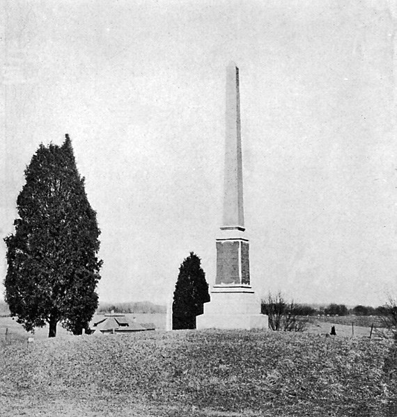 |
On December 31, 1866, the trustees of the Ladies Memorial Association paid Richard T. Brown and his wife, Marion, $225.00 for 2 1/3 acres. It was purchased
"… as a burial place or cemetery for the re-interment of the bodies of such persons as the 'Ladies Memorial Association' of said County of Fairfax shall direct to be interred therein. Provided that in all cases such bodies shall be those of Confederate States' Soldiers, who fell in battle or died from wounds incident to and while they were in the service of the Confederate States, and who are now buried within the limits of said county, or who were citizens thereof at the time of death and are buried elsewhere…"
In addition to laying off burial lots, the Ladies Memorial Association canvassed the county and eventually some 200 unknown confederate soldiers were disinterred and reburied in a common grave atop the hill in the cemetery. In 1888, the Confederate Monument Association was formed to erect a suitable monument to both the unknown Confederate dead buried in the cemetery and the Confederate soldiers from Fairfax who lay on battlefields far from home. In October 1890 the monument, designed and built by J. F. Manning Co. of Washington, D. C., was officially dedicated.
|
|
| STOP #13 |
Old Fairfax Jail (Not open to the public) |
| Coordinates |
N38 50.781 W077 18.457 |
Cipher A
Cipher B |
4-4-3, The letter is ___
No clue here. |
 |
The original "gaol" (1802) burned down in 1884. The Alexandria Jail was used until this building was completed. The jailer and his family lived in quarters in the front until the early 1950s. |
|
| STOP #14 |
Fairfax Court House (Open by appointment) and Marr Monument |
| Coordinates |
N38 50.769 W077 18.411 |
Cipher A
Cipher B |
No clue here.
1-2-2, The letter is ___ |
 |
The Fairfax Courthouse is listed in the National Register of Historic Places. George Mason petitioned the General Assembly in 1790 to move the courthouse to "such a place as should be found most convenient near the center of the County." Designed by James Wren and centrally located at the crossroads of Little River Turnpike and Ox Road, Fairfax County Courthouse was completed in 1800. During the Civil War it was occupied by Union troops and used as a headquarters and lookout station. The Fairfax Courthouse survives as a symbol of an era when the courthouse was the center of community activity for county residents.In memory of Capt. John Quincy Marr, CSA, the first Confederate officer to be killed in the Civil War during a military engagement between the opposing forces. He commanded the Warrenton Rifles during the Union cavalry attack at 3am on June 1, 1861. His body was found in a clover field 800 feet southwest of the Court House at daylight.
Note that the cannons are facing north, as do all cannons at Confederate monuments. Also note the number of cannon balls present at this memorial...you are right, there are none. In years past, pranksters rolled the cannon balls down Main St. on Halloween.
|
|
Notes:
The historic marker you need to solve the book cipher is not located at these coordinates. You will encounter it as you proceed to the next tour stop.
The cross walk to the Joshua Gunnell House is located south of these coordinates. Please use caution crossing Rt. 123. The cross walk is difficult for drivers to see.
|
| STOP #15 |
Joshua Gunnell House (Business) |
| Coordinates |
N38 50.733 W077 18.409 |
Cipher A
Cipher B |
5-7-1, The letter is ___
4-5-4, The letter is ___ |
 |
The first skirmish of the Civil War occurred on Main St., June 1, 1861. Ex-Governor, "Extra Billy" Smith, a civilian, ran from this house to take charge of the Warrenton Rifles. Their commanding officer, Capt. John Quincy Marr had been killed, the first Confederate officer killed during the Civil War in a military engagement between the opposing forces (stop #14). Union Col. Johnstone was billeted here during Ranger Mosby's March 9, 1863 raid. However, Johnstone escaped capture by hiding beneath the outhouse, wearing only his nightshirt. |
|
Notes:
Stop #16 is optional on the tour because it is not on the original Courting History: A Walking Tour of Old Town Fairfax, Virginia brochure, and is slightly out of the way. City Hall is several blocks south of the Joshua Gunnell house. Though easily accessible, it makes for a long walk back to the Fairfax Museum and Visitors Center, where you left your car.
|
| STOP #16 (Optional) |
City Hall |
| Coordinates |
N38 50.473 W077 18.480 |
Cipher A
Cipher B |
No clue here.
No clue here. |
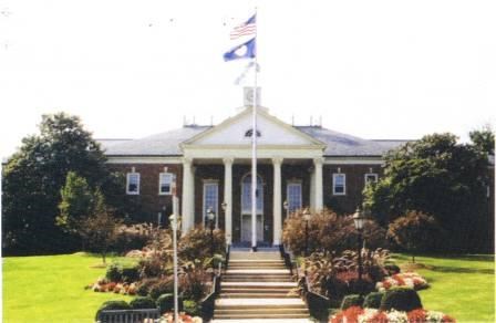 |
In 1961, the Town of Fairfax was incorporated as the City of Fairfax. The City's boundaries expanded in three directions as it grew to its present 6.4 square-miles. After an early 1970s peak of 22,700, the population has stabilized at around 21,000. |
|
| STOP #17 |
The Cache! |
 |
String together all of the letters you deciphered for Cipher A to spell the final two digits of the latitude coordinates and plug them in here:
N38 50.6 _ _ (Cipher A)
Do likewise for the longitude coordinates using Cipher B, and plug them in here:
W077 18.0 _ _ (Cipher B)
Watch for mugglers, this is a very public area!
|
|
Notes:
Help yourself to a City of Fairfax trinket.
|
The itinerary and descriptions of locations on the tour were borrowed from the Fairfax Museum and Visitors Center's brochure, Courting History: A Walking Tour of Old Town Fairfax, Virginia. The online brochure can be viewed at www.fairfaxva.gov/museumvc/MapOfHistory.asp. Other historic information and photographs were borrowed from the official City of Fairfax website, www.fairfaxva.gov, the Historic Fairfax City, Inc. website, www.historicfairfax.org, and the book, Fairfax, Virginia: A City Traveling Through Time.