Canyon Triple I Mystery Cache
-
Difficulty:
-

-
Terrain:
-

Size:  (micro)
Please note Use of geocaching.com services is subject to the terms and conditions
in our disclaimer.
Raggaschlucht

Banner created by FMBKK
FTF: 26.06.2006 teaMiata
Deutsch:
Starte bei den o.a. Koordinaten.
Dieser Cache ist Teil des drei Schluchtenweges. Um den Cache zu heben ist es nicht unbedingt notwendig die Schlucht zu begehen aber auf jeden Fall empfehlenswert. (Öffnungszeiten und Info siehe unter www.flattach.at )
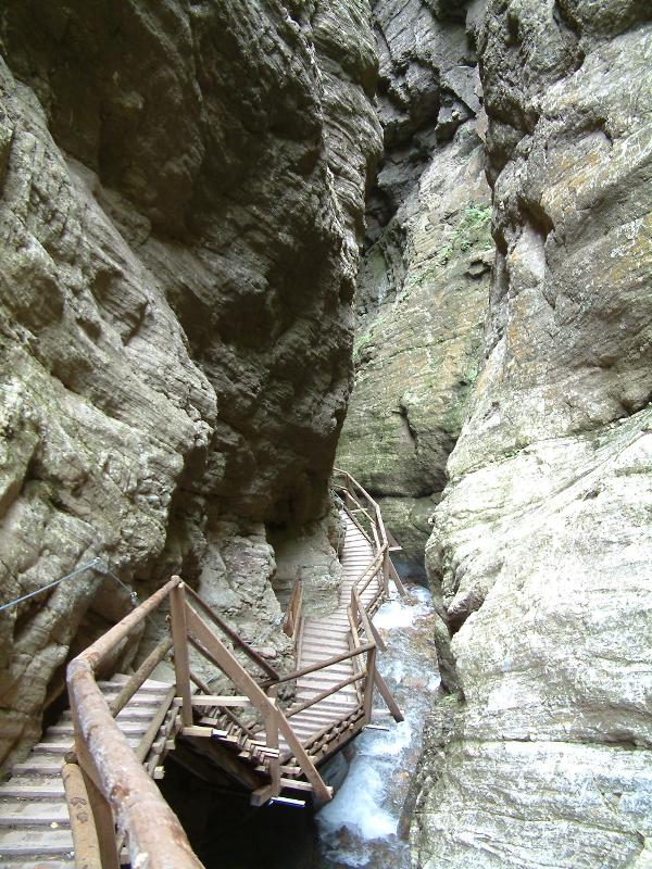
Der Cache befindet sich beim Abstieg ca. 50 m oberhalb des Weges, in nicht sehr steilem Gelände. Es ist daher nicht notwendig, in irgend einer Weise im steilen Gelände herum zu turnen und dabei sich und andere zu gefährden. Vom Begehen der Schlucht mit Kindern unter 5 Jahren würde ich abraten.
Wie groß ist das Einzugsgebiet des Raggabaches?
5 qkm = 0
10 qkm = 9
15 qkm = 7
20 qkm = 5 Antwort = A
In welcher Gebirgsgruppe befindet sich die Raggaschlucht?
Schobergruppe = 7
Kreuzeckgruppe = 8
Reißeckgruppe = 3
Goldberggruppe = 5 Antwort = B
In der Nacht vom 27. auf den 28. Juli 2003 wurde die Steganlage der Raggaschlucht zur Gänze zerstört. Wie lange dauerte die Sanierung?
3 Monate = 1
5 Monate = 8
7 Monate = 4
9 Monate = 6 Antwort = C
In jahrtausenderlanger Arbeit schuf der Raggabach eine der schönsten und gigantischsten Schluchten der Alpen! Wann wurde die Raggaschlucht erstmals für Besucher begehbar gemacht?
1882 = 4
1906 = 1
1958 = 5
1972 = 7 Antwort = D
Über hölzerne Brücken und Stiegen gelangt man sicher durch die Schlucht. Welche Länge hat die Strecke?
650 m = 2
800 m = 3
970 m = 8
1200 m = 6 Antwort =E
Welchen Höhenunterschied legt man dabei zurück?
100 m = 4
180 m = 9
200 m = 8
350 m = 0 Antwort = F
Cache: N 46° 55.ABC O 13° 08.DEF
Wenn du alle drei Canyon-Triple gefunden hast, darfst du den Banner in deinem Profil führen. Bitte bei mir anfordern.
English:
Start by the coordinates N 46° 55.754 E 13° 08.494
This cache is part of the „3 canyons path“. It’s not necessary to walk through the canyon in order to find the cache but the “Raggaschlucht” is really worth being visited! (You’ll find detailed information about opening hours and more under www.flattach.at)
When descending, the cache is located about 50 metres above the path in not too steep terrain. There is no need to move in the steep area and to endanger oneself and others! Moreover I would advise against taking along children under 5 years.
What size is the drainage area of the “Ragga brook”?
5 qkm = 0
10 qkm = 9
15 qkm = 7
20 qkm = 5 Answer = A
Which mountain range does the “Raggaschlucht” belong to?
Schobergruppe = 7
Kreuzeckgruppe = 8
Reißeckgruppe = 3
Goldberggruppe = 5 Answer = B
In the night of July 27th, 2003 the footbridges of the “Raggaschlucht” were totally destroyed. How long did the reconstruction last?
3 month= 1
5 month= 8
7 month= 4
9 month= 6
Answer = C
In the course of thousands of years the “Ragga brook” has created one of the most beautiful and gigantic canyons in the Alps. When did the “Raggaschlucht” first open for visitors?
1882 = 4
1906 = 1
1958 = 5
1972 = 7
Answer = D
Wooden footbridges and stairs make a safe tour through the canyon possible. How long is the distance?
650 m = 2
800 m = 3
970 m = 8
1200 m = 6
Answer = E
Which altitude difference do you have to cover?
100 m = 4
180 m = 9
200 m = 8
350 m = 0
Answer = F
Cache: N 46°55.ABC E 13°08.DEF
Additional Hints
(Decrypt)
ORNPUGR QNF SBGB; Fhpur orvz tebßra Fgrva; YBBX NG GUR CVPGHER;Frnepu arne gur ovt ebpx.