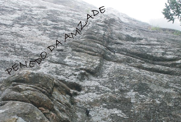
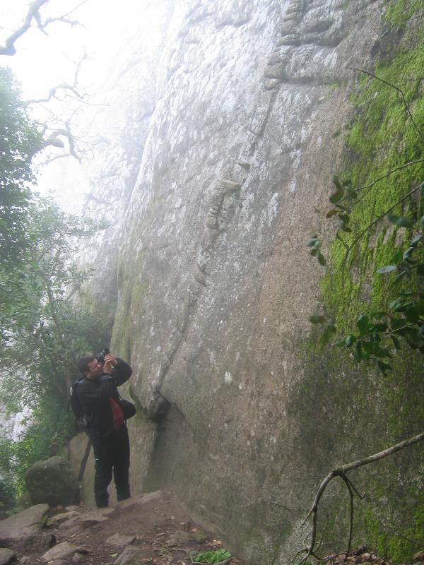
 O Penedo da Amizade,
assim denominado por se encontrar dentro dos terrenos de uma
antiga quinta com o mesmo nome, é uma enorme parede de granito
que sobressai da paisagem verdejante, ponteada por blocos
rochosos, quando se olha para o Castelo dos Mouros, da Vila
Velha de Sintra.
O Penedo da Amizade,
assim denominado por se encontrar dentro dos terrenos de uma
antiga quinta com o mesmo nome, é uma enorme parede de granito
que sobressai da paisagem verdejante, ponteada por blocos
rochosos, quando se olha para o Castelo dos Mouros, da Vila
Velha de Sintra.
Este local, bem conhecido dos amantes da
escalada, proporciona uma excepcional vista sobre a Vila Velha e os
seus monumentos, a encosta Norte da serra e o Atlântico.
Sintra, com os seus magníficos palácios,
monumentos, jardins e matas, é um local mágico e que merece uma
visita cuidada.
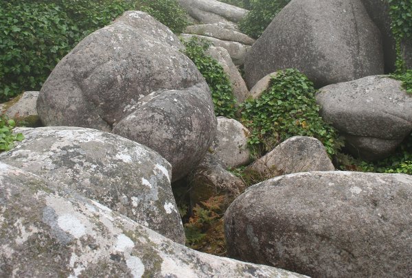
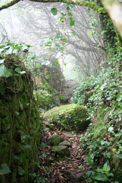
Com esta cache proponho uma visita diferente dos
habitual, atravessando zonas densamente arborizadas, em que impera
o caos de blocos típico das paisagens graníticas, até se chegar ao
cimo do Penedo da Amizade.
Até há alguns anos o acesso habitual a esta zona
era feito a pé, a partir da vila, atravessando o Parque de
Merendas. Este, no entanto, tem estado fechado para obras, pelo que
não existe acesso "oficial" ao Penedo neste momento.
Assim, proponho um caminho alternativo, que
parte do parque de estacionamento situado nas imediações do acesso
ao Castelo dos Mouros e ao Parque da Pena (entrada dos lagos), nas
seguintes coordenadas: N38 47.370 W9 23.545.
 Entrando pelo
portão do parque de estacionamento, do lado Norte da estrada,
segue-se em direcção ao Castelo dos Mouros (Disseram-me que
por vezes este portão pode estar fechado, e não há indicação
de horário... Nesse caso, improvisem... Podem por exemplo
tentar entrar pelo acesso principal do castelo, um pouco mais
acima na estrada, e depois virar à esquerda, para Oeste,
seguindo o carreiro que leva ao referido parque de
estacionamento, mas em sentido inverso, até chegar ao desvio
para a cache...) Aproximadamente 250m depois, aparece uma
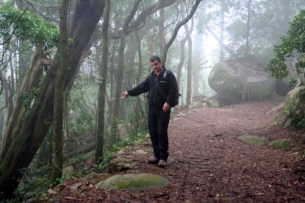
placa que indica a direcção do Castelo, para a direita. Antes
de chegar a essa zona deve-se descer para a esquerda, em
direcção a Norte (Ver foto), seguindo por um carreiro até
encontrar um muro. Deve-se seguir sempre paralelamente a esse
muro, passar sobre uma linha de água coberta de blocos, e
continuar até chegar ao carreiro que ladeia o Penedo da
Amizade.
Entrando pelo
portão do parque de estacionamento, do lado Norte da estrada,
segue-se em direcção ao Castelo dos Mouros (Disseram-me que
por vezes este portão pode estar fechado, e não há indicação
de horário... Nesse caso, improvisem... Podem por exemplo
tentar entrar pelo acesso principal do castelo, um pouco mais
acima na estrada, e depois virar à esquerda, para Oeste,
seguindo o carreiro que leva ao referido parque de
estacionamento, mas em sentido inverso, até chegar ao desvio
para a cache...) Aproximadamente 250m depois, aparece uma
placa que indica a direcção do Castelo, para a direita. Antes
de chegar a essa zona deve-se descer para a esquerda, em
direcção a Norte (Ver foto), seguindo por um carreiro até
encontrar um muro. Deve-se seguir sempre paralelamente a esse
muro, passar sobre uma linha de água coberta de blocos, e
continuar até chegar ao carreiro que ladeia o Penedo da
Amizade.
Descendo um pouco o carreiro encontra-se um
pequeno miradouro, com umas escadinhas à sua direita. Aqui é a base
de algumas vias de escalada. Continuando a descer vai-se passar
pela base de diversas das outras vias. Se, em vez de descer, se
subir um pouco pelo carreiro, chega-se ao topo do penedo e das vias
de escalada, e à zona onde se encontra a cache.
Atenção:
O acesso ao Penedo da Amizade não é proibido, mas é
proibido violar vedações e/ou muros. Assim, evitem a todo o custo
circular fora dos carreiros já existentes.
No percurso até à cache poderá ser necessário trepar e saltar
alguns rochedos, em especial se não for seguido o caminho
correcto.
Por razões de segurança, é aconselhável evitar a beira do
precipício, no alto do Penedo.
Recomenda-se a prática de Cache In /Trash
Out.
A cache:
Esta é uma cache de tamanho regular
(aproximadamente 16x25x7cm).
Encontra-se escondida debaixo de um calhau, junto ao "carreiro"
que percorre o topo do penedo, numa zona em que existe alguna
cobertura arbórea.
Caso sinta dificuldade na captação do sinal GPS, aconselho a
consulta das fotos spoiler 1 e spoiler 2.
Devido à sua localização, caso exista alguém a escalar nas vias
mais próximas ou a circular no trilho, poderá ser necessário usar
alguma descrição.
 “Penedo
da Amizade” or Friendship Rock, is so called because it
outcrops within the grounds of an old property with the same
name. It is an immense wall of granite that emerges from the
surrounding green foliage as you look towards the Moorish
Castle from the centre of Sintra Village.
“Penedo
da Amizade” or Friendship Rock, is so called because it
outcrops within the grounds of an old property with the same
name. It is an immense wall of granite that emerges from the
surrounding green foliage as you look towards the Moorish
Castle from the centre of Sintra Village.
This place is well known to rock climbers and
allows ample views of the old village centre, its monuments, the
northern slope of the Sintra Mountains and the Atlantic Ocean.
Sintra with its magnificent palaces, monuments,
gardens is a magical place and deserves a slow and thorough
visit.
With this cache I would like to allow you to explore a different
side of Sintra; a walk through densely vegetated areas where eroded
rounded granite boulders are strewn randomly, until you reach
Friendship rock.
Until a few years ago, the regular access to
this area was done on foot from the village centre and traversing
the picnic grounds. However, this has been closed for some time and
as such, there is no official access to the rock at this point in
time.
Therefore, an alternate route is proposed. This
starts near the parking area of the Moorish Castle and the Pena
Palace gardens (the zone of the ponds) at the following
coordinates: N38 47.370 W9 23.545.
 On the northern side of the parking lot, enter the gate and
follow in the direction of the Moorish Castle (Some times this
gate can be closed, and does not have any schedule
indication... In this case, improvise... You can for example
try to enter trough the main castle access, above on the road,
and then turn left (to West) and follow the path to the
parking lot, in the reverse sense, until reach the path to the
cache...) Approximately 250m further on, there is a sign,
pointing to the right that shows the way to the Moorish
Castle. Before reaching this zone, you should descend to your
left (due north; see photo), following a path until you get to
a stone wall. Follow parallel to this wall, cross the stream
covered in boulders until you get to the path that circumvents
the Rock.
On the northern side of the parking lot, enter the gate and
follow in the direction of the Moorish Castle (Some times this
gate can be closed, and does not have any schedule
indication... In this case, improvise... You can for example
try to enter trough the main castle access, above on the road,
and then turn left (to West) and follow the path to the
parking lot, in the reverse sense, until reach the path to the
cache...) Approximately 250m further on, there is a sign,
pointing to the right that shows the way to the Moorish
Castle. Before reaching this zone, you should descend to your
left (due north; see photo), following a path until you get to
a stone wall. Follow parallel to this wall, cross the stream
covered in boulders until you get to the path that circumvents
the Rock.
Descending a little further, there is a
viewpoint with some stairs to your right. This is the base of some
of the rock climbing routes. Following this path will take you past
the staring points of more climbing routes. If instead of
descending, you opt to climb the path, you will reach the top of
the Rock and the climbing routes as well as the to the zone where
the cache is hidden.
Attention:
Access to the Rock is not prohibited but climbing
fences or walls is. Avoid, at all costs, straying off the existing
paths.
On the way to the cache it may be necessary to climb and jump over
a few boulders, especillaly if the correct path is not
followed.
For safety reasons, avoid the edge of the Rock on the upper
portions.
Practice “cache in, trash out”.
The cache:
Is regular in size (approximately 16x25x7cm)
It is hidden underneath a boulder, next to the path that runs over
the top of the Friendship Rock, in a zone with some tree
cover.
If you run into difficulty, you should consult spoiler photo 1 and spoiler photo 2.
Due to its location and should anyone be rock climbing at the
time, it may be necessary to exercise some discretion.
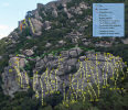
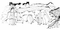
Esquemas e informações sobre as vias de
escalada / Schemes and information about the climbing
routes

Quer saber mais sobre o
Geocaching
em
Portugal?
Adere ao grupo de discussão e visita os
sites Geocaching@PT
,
GeoPorStats
e os
mapas com a localização das caches
portuguesas
Would you like to know more about
Geocaching
in
Portugal?
Join the discussion group and visit
Geocaching@PT
,
GeoPorStats and the
maps with the location of the portuguese
caches