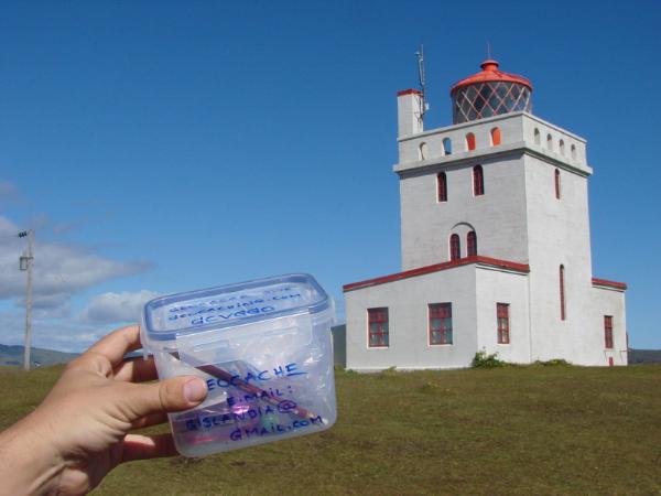
Dyrholaey Traditional Geocache
Pohatu Nuva: Thank You. It's time
-
Difficulty:
-

-
Terrain:
-

Size:  (small)
Related Web Page
Please note Use of geocaching.com services is subject to the terms and conditions
in our disclaimer.
It is said that the earth's circle which the human race inhabits is torn across into many bights, so that great seas run into the land from the out-ocean.
The cache is a glass jar, covered with stones.
Original contents: log-book, pens, a toy.
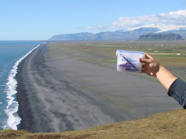
Dyrholaey (Icelandic: Dyrhólaey) is located in the south of Iceland. The Icelandic name ending on -ey might indicate that it is an island, which it is not; it's a promontory, reaching out into the ocean. It is thought to have been created during a submarine volcanic eruption approximately 80 thousand years ago. The eruption, which formed Dyrhólaey and the pillars around it (originally parts of it), presumably took place in the same way as other submarine and subglacial eruptions. In the beginning, a major tephra eruption took place and later, when the crater reached the surface of the sea, the lava started to flow and thus ensured its existence. Dyrhólaey is a promontory reaching out into the ocean on the south coast of Iceland. It is the southernmost part of the country and is around 120 m high. Off Dyrhólaey, there are rock pillars, that are unique natural formations. The roaring Atlantic and its foamy waves wash the black sands at the foot of Dyrhólaey. From there you can enjoy the sight of the varied and fantastic scenery of the Mýrdalur valley, fresh green fields and pastures. Above them, moors and tuff mountains of different shapes, and the mountains of the highland pastures, high and awesome, cut by deep ravines and gorges. Behind them, the white glacier reaches a height of almost 1450 m. To the west the Vestmannaeyjar archipelago is clearly visible, when visibility is good, and also the mountains Eyjafjöll and the glacier Eyjafjallajökull. Not far off the coast to the west of Dyrhólaey is the Kamburinn, much further out and more to the west is the stack Máfadrangur, where the Gannet colonized a few decades ago. To the south of the promontory is the stack Lundadrangur with a sizable cave, into which you can go by boat, when the weather is nice and the ocean is calm. To the east is the sheer stack Háidrangur (56 m), which the daredevil Eldeyjar-Hjalti was the first human to climb in 1893, as far as we know. The southernmost part of Dyrhólaey reaching into the sea is called Tóin, and there is the famous opening, which gives it its name Portland in English.. The surroundings are all amazingly beautiful and ever-changing from different viewpoints. A very rich birdlife can be enjoyed, and inquisitive seals are seldom far away.
History and utility
Most likely, fishermen have operated their boats from Dyrhólaey, or the shore near to it, from the time of the first settlement. Unfortunately, sources are very poor on this issue during the early centuries. Kristnisaga (Saga of Christianity), however, has it that when Gissur the White and Hjalti Skeggjason arrived in Iceland in the year 1000 to preach Christianity, people rowed towards them, as they sailed through the Dyrhólar delta. From this it can be seen that boats were then present at Dyrhólaey. Eyjólfur Guðmundsson, a farmer and a writer at Hvoll in Mýrdalur, believes that a fleet of fishing boats was operated from the shore at Kirkjufjara, south of the promontory, during the 15th, 16th, and 17th centuries.
East of Dyrhólaey, you can still see the ruins of fishermen's cottages and fishwalls, now mostly covered by vegetation. All of this area is named Garðar (Walls). The shore at Kirkjufjara mostly vanished and the fishing activity is then believed to have moved to the west of Dyrhólaey. From the 18th century, fishing boats sailed out from the sand shore west of the promontory, which is still called Dyrhólahöfn (Dyrhólar port). Many rowing boats were operated from this place until the middle of the 20th century. There is very rich birdlife in Dyrhólaey and the surrounding stacks. Normally in springtime, people collected eggs in the stacks, and still do. In the early days, this helped with the housekeeping. Both Fulmars and Puffins have been caught now and then in the promontory. Quite a few Eider Ducks nest here, and people have tended to care for the ducks in recent years, after the promontory was protected against sheep and all traffic during the nesting season.
The lighthouse
The very first lighthouse was built on Dyrhólaey in 1910. The present lighthouse was built in 1927, and the building materials were transported by boat to the port Dyrhólahöfn and pulled up onto the promontory along a cable from the shore. The lighthouse is quite a large construction, three-storeys high. During the first decades after the lighthouse was built, the lighthouse keeper had a sheepcote and a barn not far from the lighthouse, and around the houses he grew grass and made hay.
Birdlife
Few places in the country offer better opportunities for enthusiastic birdwatchers than Dyrhólaey. The various species of seabirds are most prominent in the promontory itself, and not least in the stacks. On some days the rock walls of the promontory and the stacks are almost covered with seabirds. (Source: Óskar H. Ólafsson, 2001)
Additional Hints
(Decrypt)
gurer vf n cnexvat ng gur raq bs gur ebnq hc gurer. gur pnpur vf haqre gur fgbar va gur fgbar jnyy.