Surtind, KTU #14 Traditional Geocache
-
Difficulty:
-

-
Terrain:
-

Size:  (small)
Please note Use of geocaching.com services is subject to the terms and conditions
in our disclaimer.
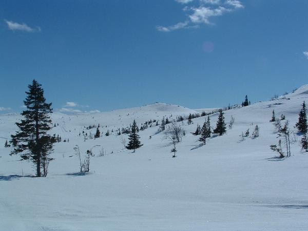
Enda en utsiktstopp i Hedalsfjella – 1094 moh.
Ta med kikkerten !
Another peak with a view in the Hedalen mountainrange – 1094 m asl.
Bring your binoculars!
Utsikten fra denne toppen er karakterisert som meget vid.
På en klar dag kan du se Hallingskarvet og Skarvheimen ute i vest.
Skogshorn og Storefjell finner du i nord-vest.
I nord finner du Gjendealpene. Store Knutsholstind, Austre Torfinnstind and Besshøi er
eksempler på prominente 2000-metre du kan plukke ut.
I nord-øst ligger Bitihorn og Rundemelle.
Synnfjell med Spåtind finner du i øst.
Mot syd ligger fjellområdene ved Norefjell med Høgevarde og Gråfjell.
I syd-vest finer du Gaustatoppen.
Navnet på denne toppen antyder at det er ganske surt her – sjelden er det vindstille.
En mer sannsynlig betydning kommer fra det gammelnorske ordet ”surt” – sort.
Det forteller noe om fargen på berget.
På turen kan du risikere å møte ryper, eller kanskje til og med en flokk reinsdyr.
Letteste ankomst er fra Søbekkseter, omlag en times tur vinter, og to til fots om sommeren.
Stienfra Søbekk er blåmerket, men et kart er å anbefale på turen, enten Sør-Valdres (Statens Kartverk No 2555),
eller Vassfaret (N741 Kartblad 1716 III).
Vinterstid er det skiløype til foten av Surtind. Ved en granbusk finnes det en grønn
postkasse med turloggbok. Skriv gjerne i denne boka også.
Sommerstid ligger denne postkassa utenfor stien.
På toppen er det også kasse nå (per oktober 2013)
Anbefalt tur videre går ned til Fjellvann over Slafjell og tilbake til Søbekk.
Andre topper i området med tilsvarende utsikt er Sæterknatten og Slafjell.
Cachen, som er tilgjengelig om vinteren, er en liten plastboks trukket i sort duct-tape.
Opprinnelig innhold :
Kortstokk
Refleks
Skohorn
Blyant
Stor karabinkrok
Liten karabinkrok
Såpestykke
Logbok med tilbehør og FTF-sertifikat.
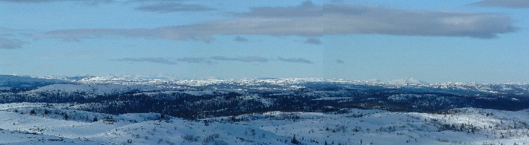
The view from this point is characterized as very wide.
On a clear day you may overview Hallingskarvet and Skarvheimen far out to the west.
Skogshorn and Storefjell is found to the north-west.
To the north you find the Gjende-alps. Store Knutsholstind, Austre Torfinnstind and
Besshøi are among the identifiable prominent above 2000m-peaks.
To north-east Bitihorn and Rundemelle is found.
Synnfjell with Spåtind is found to the east.
To the south you find the mountainranges at Norefjell with Høgevarde and Gråfjell.
To the south-west you find Gaustatoppen.
The Norwegian name of the peak may hint to the biting and brisk feeling you get here
a windy day – which is almost any day here. A more probable meaning may stem from
the old-norwegian word “surt” – black, taken from the color of the rocks here.
During your hike you may come across some grouse, or maybe even a herd of reindeer.
The easiest approach is from Søbekkseter, approximately 1 hour hike in winter,
and two by feet in the summer. The path is marked blue, but a map is highly recommended,
either Sør-Valdres (Statens Kartverk No 2555), or Vassfaret (N741 Sheet 1716 III).
During winter nearby ski-tracks take you to the foot of Surtind.
A green postbox containing a logbook for hikers is found nearby a spruce along the track.
In summertime this box is outside the path. Log your visit here as well.
At the summit you will also find a green box (as of october 2013)
A recommended roundtrip is down to Fjellvann over Slafjell and back to Søbekk.
Other nearby peaks giving similar view is Sæterknatten and Slafjell.
The cache, available during the winter, is a small plastic container coated in black duct-tape.
Initial content :
Deck of cards
Reflex
Shoehorn
Pencil
Large carabiner
Small carabiner
Hotel soap
Logbook with accessories and a FTF certificate
Hint :
Plott inn fjelltoppene i GPS-en, så blir det lettere å lese utsikten.
Plot the surrounding peaks into your GPSr to easier read the view.
Additional Hints
(Decrypt)
[Nor] Haqre ra fgrva 4 zrgre føe sbe ineqr
[Eng] Haqre n fznyy ebpx 4 zrgref fbhgu bs pnvea