|

 Dominada a Sul pela Serra de Sintra, a Ericeira tem a seus pés quatro praias banhadas pelo Atlântico. Esta privilegiada localização leva a que a vila receba milhares de veraneantes, à procura do Sol, das praias, da imensa beleza paisagística. Dominada a Sul pela Serra de Sintra, a Ericeira tem a seus pés quatro praias banhadas pelo Atlântico. Esta privilegiada localização leva a que a vila receba milhares de veraneantes, à procura do Sol, das praias, da imensa beleza paisagística.
 Reza a lenda que o nome Ericeira significa, na origem, "terra de ouriços", devido aos numerosos ouriços do mar que abundavam nas suas praias. No entanto, investigações mais recentes apontam o ouriço caixeiro e não o do mar como inspirador do nome. Reza a lenda que o nome Ericeira significa, na origem, "terra de ouriços", devido aos numerosos ouriços do mar que abundavam nas suas praias. No entanto, investigações mais recentes apontam o ouriço caixeiro e não o do mar como inspirador do nome.
A história da Ericeira remonta a cerca de 1000 a.C, com os fenícios. O seu primeiro foral data de 1229, concedido pelo então Grão-Mestre da Ordem de Aviz, Dom Frei Fernão Rodrigues Monteiro, que assim instituiu o Concelho da Ericeira. É na carta de foral que surgem as primeiras referências aos pescadores da Ericeira, estando bem presente o cuidado do legislador em acautelar os direitos e deveres dos que se encontravam sujeitos às tutelas dos donatários:"(...) Quanto aos pescadores, dêem a vigésima parte do pescado que matarem no mar. De doze peixes, levem um para conduto antes de darem a vigésima parte, e se matarem congro, comam-no. Do pescado que encontrarem morto, não paguem foro. De baleia, dêem a vigésima parte. De toninhas e delfins sem impedimento, em ocasiões de fome (...)". No século XIII, a baleia, toninha e delfim eram as espécies mais pescadas, tendo dado lugar, já no século XVI, à raia, ao rodo valho e à pescada. Em 1547, D. João III concede aos pescadores ericeirences a permissão de venderem o peixe "a olho" e não "a peso", costume que ainda há 30 anos se mantinha.
 Deve-se ao porto da Ericeira o desenvolvimento da vila, noutros tempos habitada quase só por gente do mar, que formou durante muitos séculos um grupo étnico-geográfico denominado “jagoz”, diferenciado dos restantes habitantes da região Saloia, possuindo uma linguagem com características muito próprias. O movimento comercial do porto da Ericeira tornou-o num pólo fundamental da economia da região. Relatos datados de 1834 dão conta de que nesse ano ali fundearam 175 embarcações, que ora transportavam produtos para a vila - principalmente cereais - que de ali eram distribuídos para o interior do país, ora os exportavam para os portos do Algarve, ilhas e outros - especialmente vinhos e seus derivados. A Alfândega da Ericeira abrangia então uma área que se estendia de Cascais à Figueira da Foz, sendo o seu porto considerado o quarto mais importante do país, atrás dos de Lisboa, Porto e Setúbal. Com a construção do caminho-de-ferro do Oeste e o desenvolvimento dos transportes terrestres, o porto da Ericeira foi perdendo importância. Nos finais do século XIX instalaram-se na vila armações fixas de pesca da sardinha que vieram alterar as antigas características piscatórias, mas que tiveram um papel sócio-económico importante, chegando a empregar, só na faina do mar, à volta de 500 homens. Deve-se ao porto da Ericeira o desenvolvimento da vila, noutros tempos habitada quase só por gente do mar, que formou durante muitos séculos um grupo étnico-geográfico denominado “jagoz”, diferenciado dos restantes habitantes da região Saloia, possuindo uma linguagem com características muito próprias. O movimento comercial do porto da Ericeira tornou-o num pólo fundamental da economia da região. Relatos datados de 1834 dão conta de que nesse ano ali fundearam 175 embarcações, que ora transportavam produtos para a vila - principalmente cereais - que de ali eram distribuídos para o interior do país, ora os exportavam para os portos do Algarve, ilhas e outros - especialmente vinhos e seus derivados. A Alfândega da Ericeira abrangia então uma área que se estendia de Cascais à Figueira da Foz, sendo o seu porto considerado o quarto mais importante do país, atrás dos de Lisboa, Porto e Setúbal. Com a construção do caminho-de-ferro do Oeste e o desenvolvimento dos transportes terrestres, o porto da Ericeira foi perdendo importância. Nos finais do século XIX instalaram-se na vila armações fixas de pesca da sardinha que vieram alterar as antigas características piscatórias, mas que tiveram um papel sócio-económico importante, chegando a empregar, só na faina do mar, à volta de 500 homens.
Se a vila deixou ao longo do século XIX de ser um entreposto comercial, nunca perdeu a visita de "forasteiros", desta vez de veraneantes que passaram a procurá-la devido às suas características climáticas e ao alto teor de iodo das suas praias. Charles Lepierre, engenheiro químico, considerou-as, há mais de 50 anos, como "o fulcro da maior concentração de iodo de toda a costa portuguesa". Hoje, a Ericeira continua a ser muito procurada pelos veraneantes em busca das praias, da gastronomia e da pesca desportiva.
 Dominated in the South by the Sintra Mountain range, Ericeira has its feet four beaches bathed by the Atlantic. This privileged location makes it a very much sought after village by sun seekers and other travelers. Dominated in the South by the Sintra Mountain range, Ericeira has its feet four beaches bathed by the Atlantic. This privileged location makes it a very much sought after village by sun seekers and other travelers.
 Legend has it that the name Ericeira means, “land of sea urchins”, which had to do with the numerous sea urchins that were plentiful on its beaches. However, recent research points to porcupines and not sea urchins. Legend has it that the name Ericeira means, “land of sea urchins”, which had to do with the numerous sea urchins that were plentiful on its beaches. However, recent research points to porcupines and not sea urchins.
The history of the Ericeira goes back about 1000 b.C, with the Phoenicians. Its first charter dates from1229, granted by the then Grand-Master of the Order of Aviz, Dom Frei Fernão Rodrigues Monteiro, who thus instituted the Concelho of the Ericeira. It is in the letter of charter that the first references to Ericeira fisherman appear where the fisherman were taxed a portion of their haul depending on the type of fish that was caught. In 1547, king D. João III grants the Ericeira fisherman the right to sell their fish “by estimate” and not “by weight”, a custom that had persisted for some 30 years.
 Ericeira owes its development to its fishing port. It was largely inhabited by sea-faring people and that through the centuries formed an ethnic-geographic group called “jagoz”, differentiated from the remaining inhabitants of the Saloia region, possessing a language with particular characteristics. The commercial movement of the port of Ericeira made it a fundamental economic nucleus of the region. Stories dating from 1834 account that in this year 175 boats had anchored there, that, 1- essentially brought products to the village (mainly cereals) that were then distributed for the interior of the country, and, 2- exported them (especially wines and its derivatives) to the ports of the Algarve, islands and others. The Customs of the Ericeira comprised then an area that extended from Cascais to Figueira da Foz, and its port was considered the fourth most important one after Lisbon, Porto and Setúbal. With the construction of the railway of the West and the development of land-based transports, the port of Ericeira began losing importance. In the end of XIX century, fixed scaffoldings, for the fishing of sardines, had been installed in the village which modified the old fishing characteristics. These, however, had had an important socio-economic role providing jobs for some 500 men. Ericeira owes its development to its fishing port. It was largely inhabited by sea-faring people and that through the centuries formed an ethnic-geographic group called “jagoz”, differentiated from the remaining inhabitants of the Saloia region, possessing a language with particular characteristics. The commercial movement of the port of Ericeira made it a fundamental economic nucleus of the region. Stories dating from 1834 account that in this year 175 boats had anchored there, that, 1- essentially brought products to the village (mainly cereals) that were then distributed for the interior of the country, and, 2- exported them (especially wines and its derivatives) to the ports of the Algarve, islands and others. The Customs of the Ericeira comprised then an area that extended from Cascais to Figueira da Foz, and its port was considered the fourth most important one after Lisbon, Porto and Setúbal. With the construction of the railway of the West and the development of land-based transports, the port of Ericeira began losing importance. In the end of XIX century, fixed scaffoldings, for the fishing of sardines, had been installed in the village which modified the old fishing characteristics. These, however, had had an important socio-economic role providing jobs for some 500 men.
But if the village, throughout XIX century, became less important as a commercial nucleus, it has never lost the appeal for visits by “outsiders”, especially sun-seekers that are looking for good climate and the high concentrations of iodine of its beaches. More than 50 years ago, Charles Lepierre, a chemical engineer, considered the beaches as “the fulcrum of the biggest iodine concentration of the entire Portuguese coast”. Today, Ericeira continues to appeal to sun-seekers, gastronomes and game fishing.
A cache
Esta multi-cache levá-lo-á num passeio pela Ericeira, para que fique a conhecer alguns dos seus monumentos, ruelas e recantos…
1. Para começar, deixe o carro no parque que existe em
N38 57.861 W9 25.013
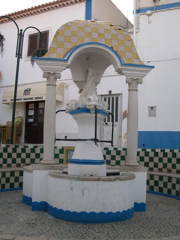
e dirija-se a pé para a Fonte dos Golfinhos (coordenadas iniciais)
(N38 57.907 W9 25.030).
 2. Chegado à fonte, procure a data inscrita num painel de azulejos. A data é composta por 4 digitos. Os dois primeiros corresponderão a A e os dois últimos a B. 2. Chegado à fonte, procure a data inscrita num painel de azulejos. A data é composta por 4 digitos. Os dois primeiros corresponderão a A e os dois últimos a B.
3. Siga para
N38 57.9(A+28) W9 25.0(B+25),
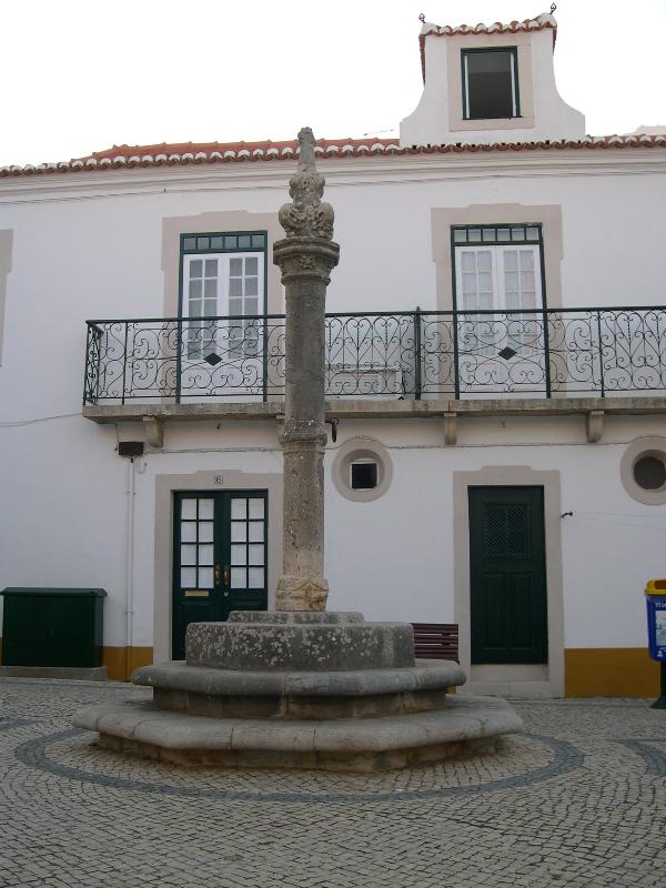
onde encontrará um pelourinho de estilo Manuelino. Nas suas imediações encontra a Igreja da Misericórdia e o Museu, dignos merecedores de uma visita. Vistos de cima, quantos lados têm a forma geométrica construída pelos degraus do pelourinho? O número lados corresponde a C.
4. Substitua o número correspondente a C em
N38 58.0(C/4)3 W9 25.130
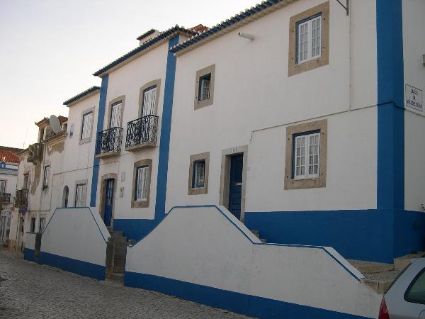
e dirija-se para este novo local, percorrendo as estreitas ruelas da zona Norte da Vila. Aproveite para apreciar a traça de algumas das construções mais antigas, de elevada beleza. Neste local encontra a Fonte do Norte, edificada na típica arquitectura da zona. O número de torneiras actualmente existentes na fonte corresponde a D.
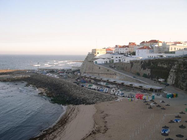
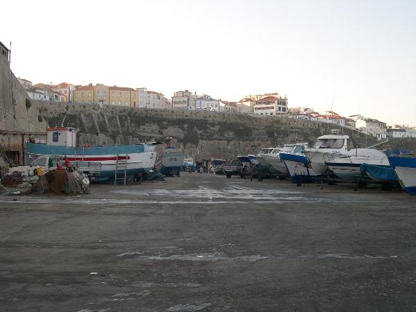
5. Siga agora pela Travessa do Algodio, para a praia com o mesmo nome, descendo depois em direcção a Sul até atingir o Porto de Pesca, nas coordenadas
N38 57.918 W9 25.(D)98.
Aqui poderá, com bastante cuidado, observar as embarcações e os aparelhos de pesca e, eventualmente, algum pescador a preparar a faina.
No local das coordenadas encontrará um candeeiro. O número de holofotes deste candeeiro corresponde a E.
 6. Percorra agora a plataforma do Porto em direcção a SE, até à Praia dos Pescadores, e suba a rampa de acesso até à Capela de Santo António, em 6. Percorra agora a plataforma do Porto em direcção a SE, até à Praia dos Pescadores, e suba a rampa de acesso até à Capela de Santo António, em
N38 57.8(E+7)1 W9 25.098.
Esta capela, também conhecida como Capela de N. Sra. da Boa Viagem, alberga a imagem desta padroeira dos pescadores desta vila, entre outras. Nas imediações das coordenadas encontrará um painel de azulejos com uma cruz e uma data em que F corresponde aos dois primeiros dígitos.
7. Com F obtenha a coordenada da cache final, a partir de
N38 57.667 W9 25.1(F+60),
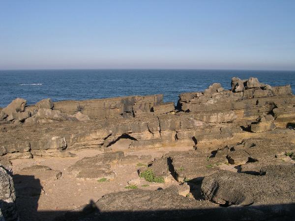
para onde se deverá dirigir atravessando o Largo das Ribas, sempre pelo passeio que acompanha as falésias, de onde se tem uma das panorâmicas mais apreciadas desta povoação, observando-se o Porto, a Praia dos Pescadores e as formações rochosas com diversos locais para a prática de pesca desportiva.
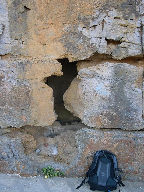
A cache encontra-se nas Furnas, uma zona com formações rochosas muito características, modeladas pela erosão, bastante procurada por pescadores e veraneantes desejosos de passear, apanhar sol e respirar o ar do mar carregado de iodo.
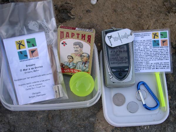
A cache está escondida num buraco junto ao tecto de uma pequena caverna.
Apesar de não caber mais que uma pessoa nesta cavidade, o acesso é bastante acessível (a entrada talvez se torne um pouco difícil para as pessoas mais corpulentas…)
Por favor seja discreto na sua busca e volte a esconder devidamente a cache, para que não haja o risco de ela desaparecer.
Caso não consiga oportunidade para procurar a cache, devido à presença de "mirones", aceito como confirmação da visita uma foto do local.
8. Depois de encontrar a cache aconselho o passeio até à zona das furnas junto ao hotel, um pouco a SE deste local, onde poderá observar os viveiros de lagostas que foram construídos nas rochas e de onde se observa a Praia do Sul e toda a costa até ao Cabo da Roca. Daqui poderá seguir para NNE, até ao largo central da vila, o Jogo da Bola, e daqui até ao local onde deixou o carro.
Espero que tenha um passeio agradável!
Obrigado pela visita.
The cache
This multi-cache will take you on a stroll through Ericeira, so that you get to know some of its monuments, alleys and hiding places…
1. To start, park the car at
N38 57,861 W9 25,013
and then walk to the Fountain of the Dolphins
(57,907 N38 W9 25,030).
 2. At this fountain, search for a date on a tile. The date is composed for 4 digits. The first two will correspond to A and the two last the B. 2. At this fountain, search for a date on a tile. The date is composed for 4 digits. The first two will correspond to A and the two last the B.
3. Follow to
N38 57,9 (A+28) W9 25,0 (B+25),
where you will find a Manueline-style pillory. Near to this point you will find the Misericórdia Church and the Museum, worthy of a visit. View from above, how many sides have the geometric form constructed by the steps of the pillory? The number sides corresponds the C.
4. Substitute number corresponding to C in
N38 58.0(C/4)3 W9 25,130.
This will direct you to a new place through narrow alleys in the northern part of the village. Appreciate the beauty of some of the old architecture of the place. Here you will arrive at the north fountain. The number of currently existing taps in the fountain corresponds to D.
5. Follows the “Travesa de Algodio”, to the beach with the same name, descending south in the direction of the fishing port, in the coordinates
N38 57,918 W9 25,(D)98.
Here you will be able to observe the fishing boats and and other fishing devices and maybe even some fishermen preparing for a trip to sea. At the coordinates you will find a lamp. The number of searchlights of this lamp corresponds to E.
 6. Go along the harbour towards SE to Fishermen Beach and then climb the ramp that accesses the Chapel of Santo António, at 6. Go along the harbour towards SE to Fishermen Beach and then climb the ramp that accesses the Chapel of Santo António, at
N38 57,8(E+7)1 W9 25.098.
This chapel, also known as the Chapel of the “Boa Viagem” (good trip) houses the patron saint of the fishermen in this village. Near the coordinates you will find a tile panel with a cross of which the first two numbers correspond to F.
7. With F you can now obtain the coordinates of the final cache
N38 57,667 W9 25,1(F+60),
From here you will have to cross the Ribas Plaza, strolling along the cliffs observing the beach, the rocky shores and general panorama.
The cache is hidden in the Furnas, a zone with very characteristic rocky formations, shaped by the erosion, which is sought after by sun bathers and others to breathe the iodine loaded sea air. The cache is hidden in a hole near the roof of one small cavity. Although not more than one person can fit here at a time it should be easily accessible.
Please be discrete in your search and replace as before so the cache does not disappear.
If you, due to the presence of "muggles", cannot search for the cache, I will accept a photo of the place..
8. After finding the cache I advise you to stroll to the furnas zone next to the hotel, a little to the SE of this place, where you will be able to observe the lobster hatcheries that have been constructed in the rocks, and from where you can observe the South Beach and all the coast to Cape Roca (the western most point of Europe). Follow the road to the NNE to the central village Plaza the Jogo da Bola, and then back to the car.
I hope that it was a pleasant and enlightening stroll!
Thank you for your visit.
Referências/References:
http://www.mafra.net/index.asp
|