Dykes and sills (Avencas Beach , Parede)
Magma that is pushed towards the surface may fail to reach the surface for two reasons. Either it encounters cooler rocks and freezes into an intrusive 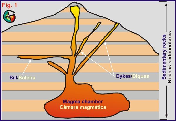 igneous rock or the magma may cease to be pushed upward and simply sit at depth for enough time for heat to escape (Fig. 1). igneous rock or the magma may cease to be pushed upward and simply sit at depth for enough time for heat to escape (Fig. 1).
The simplest form of an igneous intrusion is an injection along a crack. The easiest way for magma to enter a rock unit is to open new cracks perpendicular to the least stressed directions in a rock. These cracks are often vertical and the resulting steep, slab-like igneous intrusions are called DYKES (or dikes) (Fig. 1).
Another easy way for magma to intrude a sedimentary rock section is to follow the contact between two layers, which is inherently a zone of weakness. A plutonic rock intruded parallel to the sedimentary layers is known as a SILL (Fig. 1).
Dykes and sills are typical of the more fluid magmas. More viscous magmas, which are typically more silicon-rich, cannot flow easily into small spaces and typically move upwards as large blobs, some of them many kilometres in length, forming batholiths, e.g. Sintra, Nisa, etc.
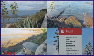
At the Avencas beach (Figs. 2 and 3), located some 17 km W of central Lisbon, in the Estoril coastline, dykes and sills can be clearly observed and therefore, this locality provides an easy learning platform and field laboratory for cachers with a keen eye for details and all students in their early phase of learning. This beach also provides a platform for a summer biology programme called “Biologia no Verão” where the public is invited to undertake a guided tour to view its biological diversity (Fig. 4).
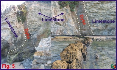
 There are several dykes that you will recognise by their much darker and reddish coloured rock in relation to the surrounding limestone. In places these dykes can be recognised by their much harder rock and therefore create positive relief features, i.e. small walls (e.g. Fig. 5 bottom right), while in others they are eroded away simply leaving linear troughs in the limestone locally with remnants of the solidified magma (Figs. 5 and 6). These are orientated roughly N-S (003º) but can vary to NNW-SSE (326º). There are several dykes that you will recognise by their much darker and reddish coloured rock in relation to the surrounding limestone. In places these dykes can be recognised by their much harder rock and therefore create positive relief features, i.e. small walls (e.g. Fig. 5 bottom right), while in others they are eroded away simply leaving linear troughs in the limestone locally with remnants of the solidified magma (Figs. 5 and 6). These are orientated roughly N-S (003º) but can vary to NNW-SSE (326º).
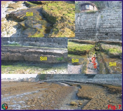
There is one large sill to be observed (N 38º 41.350’ W9º 21.748’) and it can be recognised by the same magma sitting parallel (sandwiched) to the layers of limestone (Fig. 7).
The closest parking is available at Avenida dos Principes (Parede): N 38º 41.329’ W9º 21.616’ (Fig. 3, top left).
A panoramic viewpoint is available at: N 38º 41.359’ W9º 21.715’ (Fig. 2).
The closest access to the beach is made via: N 38º 41.310’ W9º 21.616’ (Fig. 3).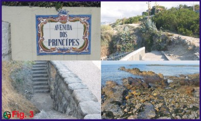
Logging the cache:
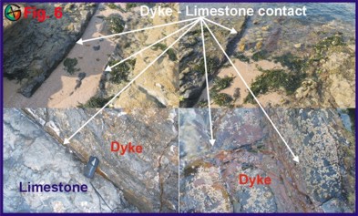
To be able to log this cache you have to show me that you can recognise dykes an sills and also have understood the difference between the two features. At point zero, measure the thickness of the dyke and e-mail me the answer. It would also be nice to have together with your log, a picture of a dyke or a sill with yourself in it – there are plenty of photo opportunities at one of several locations (listed below or you may choose another at your discretion). If you cache alone, the why not place a picture of a nice dyke-limestone contact as in Fig. 6?
-
With dyke behind you in cliff face: N 38º 41.340’ W9º 21.709’. (Look at the cliff face and ¾ up you should be able to recognize a vertical, 0.5 m-thick, band of reddish coloured rock; Fig. 5).
-
Standing on the contact of the dyke and the limestones: N 38º 41.329’ W9º 21.715’).
-
Standing on the largest dyke: N 38º 41.293’ W9º 21.727’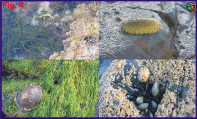
-
Standing on the sill: N 38º 41.350’ W9º 21.748’ (at this point you also have a crosscutting dyke which indicates the chronology of intrusive events: the sills were intruded first and secondly the dykes).
-
Yet another dyke: N 38º 41.301’ W9º 21.648’.
-
Or choose another location in the area: there are plenty of them (Fig. 8), but make sure the feature is easily recognisable.
Points to bear in mind:
-
Watch out when crossing the road, there is a lot of high speed traffic at this location.
-
This cache can only be claimed at low tide.
-
Do not walk on the rocks barefoot! They are SHARP and in places VERY SLIPPERY.
-
While I am not claiming this cache as kid friendly, there are usually plenty of kids around playing in the nearby sand. However, please note that small kids (< 5 ?) are at risk of falling and should be supervised by an adult at all times.
-
There are plenty of molluscs on the rocks. Please disturb them as little as possible.
-
Nothing prohibits you from enjoying a well earned swim and some beautiful views of the passing ships and the Bay of Cascais. Please enjoy to the fullest!
Diques e soleiras(Praia das Avencas, Parede)
Magma que é empurrada para a superfície pode não lá chegar por duas razões. Por uma, pode encontrar rochas mais frias e “congelar” ou solidificar formando uma rocha ígnea intrusiva ou então simplesmente remanescer em profundidade até o seu calor se dissipar por completo (Fig. 1).
A maneira mais fácil para formar uma intrusão ígnea é por injecção ao longo de uma fractura. Estas fracturas são muitas das vezes verticais, ou quase, e resultam em intrusões lineares que dão pelo nome de diques (Fig. 1).
Outra maneira que a magma pode intruir uma rocha sedimentar é seguir um nível de coesão mais fraca, por exemplo, o contacto entre duas camadas de rocha. À intrusão resultante deste modo dá-se o nome de soleira (Fig. 1).
Diques e soleiras são tipicamente formados por magmas mais fluidas. As magmas mais viscosas, tipicamente mais ricas em silício, não conseguem intruir espaços mais pequenos e tendem a ascender em formas tipo “balão” alguns dos quais podem medir muitos kilometros de diâmetro e formam batólitos ex. Sintra, Nisa, etc.
Na praia das Avencas (Figs. 2 e 3), situada na Parede, em plena Costa do Estoril, diques e soleiras são facilmente observados e o local é um ideal laboratório de campo para todos os cachers interessados por facetas da geologia e também para estudantes do primário e secundário. Esta praia também foi seleccionada para um programa de Biologia no Verão para poderem observar a sua riqueza biológica (Fig. 4).
 Os vários diques distinguem-se pela sua rocha de cor muito mais escura e ferruginosa do que os encaixantes calcários. Em alguns locais a magma que deu origem aos diques (e soleiras) é muito mais competente que os calcários pelo que forma pequenos “muros” (Fig. 5, canto inf. direito) de relevo positivo enquanto que noutros locais, em que a magma foi intruída com mais gás (na forma de bolhas), foram erodidos e simplesmente restam sanjas rectilíneas por vezes ainda com restos de magma em certos locais (Fig. 5 e 6). Os diques tem orientação que varia de N-S a NNW a SSE. Os vários diques distinguem-se pela sua rocha de cor muito mais escura e ferruginosa do que os encaixantes calcários. Em alguns locais a magma que deu origem aos diques (e soleiras) é muito mais competente que os calcários pelo que forma pequenos “muros” (Fig. 5, canto inf. direito) de relevo positivo enquanto que noutros locais, em que a magma foi intruída com mais gás (na forma de bolhas), foram erodidos e simplesmente restam sanjas rectilíneas por vezes ainda com restos de magma em certos locais (Fig. 5 e 6). Os diques tem orientação que varia de N-S a NNW a SSE.
Na zona existem várias soleiras que conferem à paisagem uma espécie de degraus compostos por calcários e magma inter estratificada ou seja, tipo sandes com as várias camadas do recheio (Fig. 7). O local mais emblemático é no ponto N 38º 41.350’ W9º 21.748’ onde se observa uma grande soleira com a parte superior exposta e ainda um dique que corta a soleira logo a W deste ponto.
O local de estacionamento mais próximo é na Avenida dos Principes, Parede, cujo acesso, via Av. Marginal, só pode ser feito no sentido Lisboa-Cascais: N 38º 41.329’ W9º 21.616’(Fig. 3, canto sup. esquerdo).
O ponto N 38º 41.359’ W9º 21.715’ apresenta um bom sítio para obter uma vista panorâmica sobre a Praia das Avencas (Fig. 2) e Baía de Cascais.
O acesso à praia é feito por: N 38º 41.310’ W9º 21.616’ (Fig. 3).
 Para logar a cache: Para logar a cache:
Para o vosso log desta earthcache ser válido tem que demonstrar que perceberam a diferença entre diques e soleiras e também que conseguem identificar estes dois aspectos geológicos básicos. No Ponto zero, meçam a espessura do dique e enviem-me a resposta por mail. Porque não juntar ao vosso log uma ou várias imagens de diques e soleiras contigo na mesma? Existem vários pontos para tirar fotos espectaculares (ver lista em baixo). Se és caçador solitário mete uma imagem do teu GPSr no contacto de um destes aspectos geológicos que mostre também algum do panorama geral.
-
Com o dique atrás de ti na arriba: N 38º 41.340’ W9º 21.709’. (A ¾ da arriba deves poder identificar uma banda de rocha mais avermelhada a correr na vertical com cerca de 0.5 m de espessura; Fig. 5).
-
Em cima do contacto entre o dique e os calcários: N 38º 41.329’ W9º 21.715’).
-
Em pé no dique mais possante visível na área: N 38º 41.293’ W9º 21.727’
-
Em cima da soleira: N 38º 41.350’ W9º 21.748’ (neste ponto existe também uma dique que corta a soleira que evidencia a cronologia dos eventos intrusivos: primeiro intruiram as soleiras e em segundo lugar os diques).
-
Mais um dique: N 38º 41.301’ W9º 21.648’.
-
Ou escolhe outro local na zona. Existem muitos (Fig. 8) mas tenham a certeza que o aspecto geológico que pretendem ilustrar é facilmente reconhecível.
Cuidados a ter:

 The most exciting way to learn about the Earth and its processes is to get into the outdoors and experience it first-hand. Visiting an Earthcache is a great outdoor activity the whole family can enjoy. An Earthcache is a special place that people can visit to learn about a unique geoscience feature or aspect of our Earth. Earthcaches include a set of educational notes and the details about where to find the location (latitude and longitude). Visitors to Earthcaches can see how our planet has been shaped by geological processes, how we manage the resources and how scientists gather evidence to learn about the Earth. To find out more click HERE. The most exciting way to learn about the Earth and its processes is to get into the outdoors and experience it first-hand. Visiting an Earthcache is a great outdoor activity the whole family can enjoy. An Earthcache is a special place that people can visit to learn about a unique geoscience feature or aspect of our Earth. Earthcaches include a set of educational notes and the details about where to find the location (latitude and longitude). Visitors to Earthcaches can see how our planet has been shaped by geological processes, how we manage the resources and how scientists gather evidence to learn about the Earth. To find out more click HERE.
|