Klint, Odsherred nr. 1 Multi-cache
-
Difficulty:
-

-
Terrain:
-

Size:  (regular)
Please note Use of geocaching.com services is subject to the terms and conditions
in our disclaimer.
|
Husk af afslutte dit fund med en god logning.
En god logning hjælper fremtidige findere af cachen og glæder cacheejer.
|
|
En tur i istidslandskab. A tour in the Ice age. Der er konstateret en hugorm tæt på cachen, pas på små børn og hvor i leder!!
Beware of snipers!! Some has been seen near the cache. 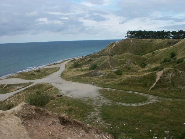
For 15.000 år siden blev Klint Bakker dannet, da det "ungbaltiske" isfremstød fra syd skrællede og skubbede en del af den danske undergrund op og dannede en række morænebakker. Morænebakkerne har efter isens tilbagesmeltning ligget som en række øer i det såkaldte "Stenalderhav" for ca. 7.000 år siden.
Havets konstante nedbrydning af moræneøerne har efterladt lange stenvolde, som sammen med landhævningen har sammenkittet moræneøerne til det landskab, der ses i dag.
Referencer:
www.ellingelyng.dk/Klint.htm
Cachen er kun tilgængelig til fods, målt højde over havet: 27 m. Respekter venligst grundejerforeningens anvisninger. Hint kan bruges før klatring.
Trin 1. Parker ved N 55 57.569, E 011 35.670 Her ser du resterne af en gammel tjæregryde, hvor mange skorstene er der ? Kald det A.
Trin 2. Gå til N55 57.633 E 11 35.xyz hvor x=7-A, y=A-1, z=A+1, Her er antallet af flagstænger B. Hvor mange dyr nævnes/vises på vejrhanen ? Kald det C.
Trin 3. Gå til N 55 57.rst E 11 34.xyz hvor r = A+5, s=B+4, t=C+3 og x=A+8, y=B+7, z=C-1, siden hvornår er der udvundet kalk ? Kald det DEFG.
Trin 4. Gå til N 55 57.rst E 11 35.xyz hvor r=E-1, s=A-1, t=B+1 og x= C-2, y=G+2, z=E-2
Cachen er en grøn camoufleret boks og indeholder fra starten:
FFC
En pakke sukkerfri CASIS bolcher
Tee-sæt fra Smørum golf-klub
Kippers (fra Rådhus-cachen)
Logbog
Blyant
Blyantspidser
Muggler-information.
English:
About 15.000 years ago, “Klint hills” were made, when the young Baltic ice progress from the south scraping and forcing a part of the Danish underground structure upwards and build a series of moraine hills.
When the ice sheets melted, about 7000 years ago, these hills remained visible as a row of islands in the so-called “Stone age sea” known as the Littorina see. The hills were subject to constant erosion by the see, which has left behind long banks of stone.
Together with subsequent geological upheaval this erosion has joined the moraine islands together creating the landscape today.
References:
www.ellingelyng.dk/Klint.htm
The Cache is only available on foot. Measured height above see level is 27 m. The hint can be used before climbing. Respect kindly the rules of the landlords community.
Step 1. Park at N 55 57.569, E 011 35.670 Here you see the remains of an old oven. How many chimneys are there? Call it A.
Step 2. Go to N 55 57.633 E 11 35.xyz where x=7-A, y=A-1, z=A+1, Here the number of flagpoles is B. How many animals are mentioned/displayed at the weather vane? Call it C.
Step 3. Go to N 55 57.rst E 11 34.xyz where r = A+5, s=B+4,t=C+3 and x=A+8, y=B+7, z=C-1, since when has chalk been exploited? Call it DEFG.
Step 4. Go to N 55 57.rst E 11 35.xyz where r=E-1, s=A-1, t=B+1 and x= C-2, y=G+2, z=E-2
The cache is a green camouflaged box and the contents from the beginning are:
FFC
A package of sugar free CASIS candy
Tee-set from ”Smørum” golf-club
Kippers (from the ”Rådhus” cache)
Logbook
Pencil
Pencil sharpener
Muggler-information.
Additional Hints
(Decrypt)
QN: gnt ghera ynatf xnagra uøwer bz
RA: Gnxr gur gevc nybat gur evz ba lbhe evtug fvqr