
 The Upper Newport Bay is thought to have formed 300,000
years ago when sea levels were lower than they are now due to
a glacial period. At that time, geologists estimate that this
area received about 80 inches of rain a year. This likely
produced year-round flow in the ancient Santa Ana River that
flowed through the channel below you and southward beneath
Upper Newport Bay.
The Upper Newport Bay is thought to have formed 300,000
years ago when sea levels were lower than they are now due to
a glacial period. At that time, geologists estimate that this
area received about 80 inches of rain a year. This likely
produced year-round flow in the ancient Santa Ana River that
flowed through the channel below you and southward beneath
Upper Newport Bay.
At that time, the river would have flowed though a flat flood
plain. Had any of the hills you see around you today existed, the
river would have taken a different course. After the river had
eroded out a stable
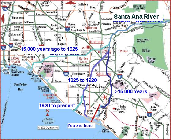 course, the Newport Mesa and
San Joaquin Hills began to slowly uplift as a result of
movement along the Newport-Inglewood fault zone. Flow in
ancient Santa Ana River was able to maintain its course
throughout the uplift by eroding the land faster than it was
uplifted. This resulted in the steep cliffs you see
surrounding the bay, such as the 100 foot cliffs across the
bay to the east.
course, the Newport Mesa and
San Joaquin Hills began to slowly uplift as a result of
movement along the Newport-Inglewood fault zone. Flow in
ancient Santa Ana River was able to maintain its course
throughout the uplift by eroding the land faster than it was
uplifted. This resulted in the steep cliffs you see
surrounding the bay, such as the 100 foot cliffs across the
bay to the east.
 Rising sea levels completely
submerged the bay until about 15,000 to 25,000 years ago. This
submersion effectively stopped the continued erosion of the
river channel as the Newport Mesa continued to rise. While the
bay was submerged, the ancient Santa Ana River also found a
new path emptying into the ocean at Alamitos Bay.
Rising sea levels completely
submerged the bay until about 15,000 to 25,000 years ago. This
submersion effectively stopped the continued erosion of the
river channel as the Newport Mesa continued to rise. While the
bay was submerged, the ancient Santa Ana River also found a
new path emptying into the ocean at Alamitos Bay.
Recent lining of the creeks that continue to drain into the
Upper Newport Bay has resulted in the filling in of the bay with
more sediment than would be expected in a natural system. As a
result the bay has been dredged to maintain its current
configuration.
Filling in of bays is a natural process, but not at the rate
that had been observed in the years since the area was urbanized.
Natural processes would eventually fill in the bay, turning it into
a marsh, then open grass land if allowed to continue.
Logging requirements:
Send me a note with :
- The text "GCPFR5 Submerged River Valley - Upper Newport Bay" on
the first line
- The number of people in your group.
- What features of the drainage channel that the bridge crosses
over has contributed to the speed that the bay has been
filling.
- What features are seen in other flood control channels
throughout the watershed.
The following sources were used to generate this
cache. None of this cache was original work.
- Colburn, Ivan P. (California State University,
Los Angeles) THE ROLE OF ANTECEDENT RIVERS IN SHAPING THE SOUTHERN
CALIFORNIA COAST, AAPG Pacific Section / SPE Western Regional Joint
Meeting, May 19-24, 2003, Long Beach, California, U.S.A. (Abstract
only)
- Norris, Robert M. Robert W. Webb, Geology of
California Second Edition, John Wiley & Sons, Inc.
1990
- Text for Geology 303, Coastal Systems and Human
Impacts, a CSU Long Beach Department of Geological Sciences Course,
http://www.cnsm.csulb.edu/departments/geology/people/bperry/geology303/geol303text.html
-
http://www.ctahr.hawaii.edu/brulandg/teaching/CS04Formation.pdf
-
http://www.ocparks.com/uppernewportbay/default.asp?Show=History
- Image Source:
EagleAerial July, 2003