Roamin' Roman Ruins (Monmouthshire) Multi-cache
Roamin' Roman Ruins (Monmouthshire)
-
Difficulty:
-

-
Terrain:
-

Size:  (small)
Please note Use of geocaching.com services is subject to the terms and conditions
in our disclaimer.
Caerwent village is built within the walls of the Roman City of Venta Siluram and a quiet village setting make this a great place to explore. Great fun for children while solving the clues! The cache is suitable for wheelchair cachers but you will require assistance with two of the clues.
The Romans built the town soon after their arrival in Wales in about AD70 to house the local Silurian people believed to be from nearby Llanmellin hill fort. The town today provides some of the most impressive Roman ruins in the country, particularly the town walls which survive to several meters high on the south side and are amongst the best preserved in Britain. The ruins have been excavated and preserved by the Welsh Historic Monuments commission (CADW) and are completely open to view and explore though please read the warning signs about climbing on the excavated ruins with the exception of the east, south and west walls where there are paths on the top as well as along the bottom. The walls are quite high so keep an eye on young children as you walk around. Dogs are allowed round the site but as sheep graze in some parts they should be kept on a lead.
The walk from the east gate (Q5) around the walls to the south of the village (Q6 and 7) isn’t suitable for wheelchairs because there are steps up to the top of the wall walk and the path along the bottom of the wall is grass and quite rough. If you follow the order of the questions then when you get to question 5 (east gate) you can back track up the road to the church (question 8) and then the final.
The questions we've set will take you to the most impressive parts of the site. If you want to see the whole site then follow the official route and visit all the locations. You'll still be able to get the answers you need. The cache location coordinates are N51° 3A.BCD W2°4E.FGH
Question 1: The starting point is the car-park where you'll find a large information board and map of the site. There are also 4 more information boards detailing the history of the whole area inside the covered building. From one of these information boards, what was the estimated population of Venta Siluram in the 3rd and 4th centuries? You need a four digit number. The first digit will be F.
N51° 36.710 W2° 46.251
Question 2: At the Courtyard House (information board 12) look at the ruins and the room furthest from the information board. How many hypocaust (heating) pillars are there (standing or fallen)? Please note they are of slightly different heights. You will get a 2 digit number. The second digit is A.
N51° 36.738 W2° 46.191
Question 3: Go to the Forum Basilica site (information board 8). This is the most impressive ruin in Caerwent. What is the height of the Basilica in feet? The first digit is E.
N51° 36.708 W2° 46.046
Question 4: Now walk from the Basilica to the Temple (information board 9). In what year was the temple believed to have been built? Add these 3 numbers together and then add D to give you B.
N51° 36.670 W2° 46.043
Question 5: Walk down the main street towards the East Gate (information board 6). In what century were the walls probably built? Add G to this number to give you H.
N51° 36.650 W2° 45.897
Question 6: Walk either along the top of the wall (there is a path) or the bottom of the wall to the south east corner, information board 5. What is the estimated area of the site in hectares? The first digit is D.
N51° 36.559 W2° 45.929
Question 7: Continue along the south walls - which still stand in places to over 5 meters - to information board 3. There is a picture of one of the bastions with several Roman soldiers. How many are standing? Subtract D from this number to give G.
N51° 36.567 W2° 46.108
Question 8: You can either continue along the south walls back to the main road to enjoy the whole site or take the footpath that goes up to the church. On the tower of the church you'll find a door with a plaque. How many years are being celebrated? The second digit is C.
N51° 36.647 W2° 46.128
You now have all the answers to complete the final location waypoint and find the cache - N51° 3A.BCD W2°4E.FGH
Plan of the Roman site with official route and waypoints. 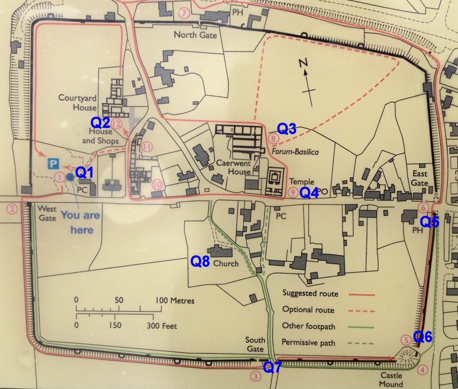
Additional Hints
(Decrypt)
Ybj qbja ol jnyy naq cbyr