Visit the friendly and helpful Geocaching Ireland discussion
Forums
Getting there ...
By car: Drive east into the port from Outer Orbital
Junction 80 near the East Link Toll Bridge (Sean Moore Rd/South
Bank Rd) and take the first road left into Whitebank Rd.. Follow
the road from there to the end of the peninsula.
(This is an industrial and port area, so for cycling and walking
(etc.) I strongly recommend the public transport route.
NOTE: If you are passing travellers' caravans > you are on
the right road).
By Public Transport: Dublin Bus (01-8734222) #2 or #3 to
Beach Road, Sandymount, or DART (01-8366222) to Sandymount Station.
From Sandymount walk towards Sean Moore Park (N 53° 20.081' W 006°
12.763'). If you are taking the bus get off once you are in view of
the sea/beach.
Once you reach the sea walk away from the road and follow the
footpath along the coast till you reach the road behind the
powerplant.
NOTE:
The Wall is very exposed and even if it looks like a fine day
it will do you no harm to be prepared for rougher weather (i.e.
rain, wind & waves).
This is a popular spot for Dubliners for a walk, especially on the
weekend. Please be discreet!
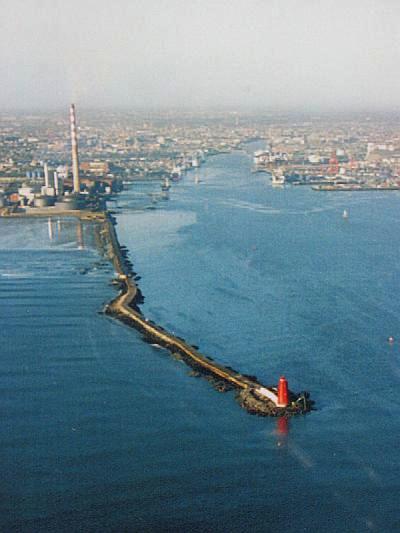
Aerial view of the Great South Wall, with Dublin
Port and City Centre in the background
Finding it ...
The coordinates at the top get you to a sign post which tells
you a bit more about this place.
- Take a note of the height of the Lighthouse! -
From here move on to
N 53° 20.465'
W 006° 09.828'
- Note the year the Half Moon Club was founded! -
The next stop is fairly obvious - go to
N 53° 20.527'
W 006° 09.072'
- Note the number of solar panels on the top -
- (incidentally this is the same number as there are windows NOT
facing the wall) -
(The spot you are standing at now used to be in the middle of
Dublin Bay.
You are now almost equal distance from Dun Laoghaire, Howth and
Dublin City Centre.)
The Final Cache Location can be found at
N 53° 20.abc'
W 006° 10.xyz'
To fill the gaps:
abc = Take the year the Half Moon Swimming Club was founded,
divide this by 2 and subtract 510 from the result = abc (fill in
the result where it says abc in the cache location)
xyz = Take the number of solar panels on the Lighthouse, add
three and multiply the result with the height of the light house in
feet = xyz (fill in the result where it says xyz in the cache
location)

About this Place...
Poolbeg is an industrial peninsula on reclaimed land stretching
from Irishtown, along the south bank of the Liffey and out along
the Great South Wall into Dublin Bay. The twin towers of the
Poolbeg power station are a Dublin landmark visible across the
entire city.
As you might have noticed on your aproach, Poolbeg is also where
the Ringsend Waste Water Treatment Plant, one of the largest and
most modern facilities of it's kind in the world, is located.
Irish Culture Special...
If you take the aproach by road, through the port, there is a
good a chance that you might be treated to a display of Irish
ethnic minority culture.
Most of the time there are travellers' (or tinkers' as they used
to be known) caravans parked on the side of the approach road.
Alltough it might not look like it: You are still on the right
road.
The Travellers (or Pavees as they call themselves) are a
minority community indigenous to Ireland who have existed on the
margins of Irish society for centuries. They share a common
descent, but have distinct cultural practices - early marriage,
desire to be mobile, a tradition of self-employment, and so on.
They also have distinct rituals of death and cleansing, and a
language they only speak among their own.
For more information on travellers check HERE or HERE.
History...
For centuries the approach to Dublin Port had been plagued by
sandbars obstructing the entrance and also by frequent squalls and
stormy conditions. To alleviate the situation, in 1716, the Ballast
Office (predecessor of the Dublin Port Company) commenced the
city's most ambitious civic construction at the time. From the
harbour at Ringsend to Poolbeg Lighthouse a sea wall of 3 miles (5
Km) in length, the world's longest at the time, was built.
Initially the eastern part of the Great South Wall was composed
of wooden piles on the outside filled in between with gravel and
the place where those started where known as 'The Pile
Ends'.
The wall was more or less finished in 1786. Meanwhile at the
“Head of the Piles” (the end of the wall) an island of
masonry was laid down on which Poolbeg Lighthouse was built. It was
ready in 1767 and initially operated on candlepower! - (reputedly
the first in the world to do so) but changed to oil in 1786.
Poolbeg is also the place where the first levelling of Ireland
was carried out between 1839 and 1843. It was referred to a datum
taken to be the level of low water of a spring tide observed at
Poolbeg Lighthouse in Dublin Bay on April 8th, 1837. (Thanx Marmota
Monax)
For many years to save travel time, passengers and packets of
mail landed at the end of the main wall, or the Pidgeon's House,
from where they were rowed to the city in boats.
"At the point then known as "the pile ends," where the
original line of wooden piles ended, and the Pigeonhouse now
stands, the port authorities erected a massive wooden house,
strongly clamped with iron, to serve as a watch house, store house
and place of refuge for such as were forced to land there by stress
of weather; and between this place and Ringsend, a number of boats
used to ply in summer, conveying pleasure-seeking citizens of that
day to what had grown to be a favourite rendezvous while the works
were in progress.
A man named Pidgeon who lived in the wooden house and acted
as caretaker of the works and tools, finding the place become such
a public resort, fitted out his quarters as neatly as possible,
and, assisted by his wife and family, made arrangements for
supplying meals and refreshments to visitors. He also purchased a
boat to hire to his guests, had it painted and finished in an
attractive manner, and as he dealt with only the best class of
visitors, his rude hostelry soon grew to be a noted resort of
distinguished citizens and wits, while the owner found himself on
the fair road to fortune.
His house came to be known to all the Dublin folk as
"Pidgeon's House," or the Pigeonhouse, and even after he and his
family had gone the way of all flesh, and the old building, having
served its purpose, had fallen into decay, the name was perpetuated
in the title of the stronghold that in after years rose over its
ruins."
from Weston St. John Joyce, 1920
A fort, a hotel and revenue barracks were build on the spot in
later years, but have all since been removed. The ruins you can see
today at the beginning of the wall are the last remnants of those
buildings.
To the west of here land has been reclaimed over the centuries and
what was once in the middle of the bay is now at the end of an
peninsula.