Mendota Earthcache EarthCache
-
Difficulty:
-

-
Terrain:
-

Size:  (other)
Related Web Page
Please note Use of geocaching.com services is subject to the terms and conditions
in our disclaimer.
NOTE: During the winter, due to the snow over ice, the terrain rating is given an elevated 3, even though it's quite flat.
Also, visitors who enter the park in vehicles are required to obtain either a daily or annual vehicle permit.
While you're visiting this cache, you might want to try the physical cache just 50 feet away: "Northern Pike at Ft. Snelling State Park"
Hmmmmm . . . that one might have floated away, it's disabled currently.
The hike from the parking area at the trailhead to the posted coordinates is lengthy (about 1.7 miles each way).
The posted coordinates are at a bench on Pike Island in Fort Snelling State Park at the confluence of the Minnesota river and the Mississippi river.
How much water is mixing together here? The average (over many years) flow of the Minnesota river at this confluence is about 34000 gallons per second; for the Mississippi river, it's about 55000 gallons per second.
Seeing these two rivers come together is impressive. The geologic story of this confluence is even more impressive. About 20,000 years ago, the Laurentide ice sheet covered this region. The glacier retreated and advanced several times over the next 10,000 years. With each retreat, great reservoirs of fresh water were created. One of these reservoirs grew to be the largest fresh water lake for which we have evidence of existence that has ever formed.
This reservoir is named Lake Agassiz. The first evidence of Lake Agassiz is during one of the last retreats of the glacier 11,700 years ago. Lake Agassiz's southern border was near Fargo, and it extended northward a great way into northern Canada. It drained and refilled and finally drained for good between 7,500 and 8,500 years ago. The major outlet for water from Lake Agassiz was what is now the Minnesota River Valley. The river proceeding from Agassiz was called the River Warren. It was a river of incredible flow and power. As it passed through the area where Fort Snelling stands today, it was joined by a much smaller tributary (eventually called the Mississippi).
Downtown St. Paul was the site of the River Warren Falls 11,700 years ago. Geologists believe that at 200 feet drop and ½ mile wide it was the largest waterfall (flow) to have ever existed in America. In only about 1700 years, these falls had receded back to where the Minnesota and Mississippi come together today. The reason the waterfall was able to recede so far so quickly was due to the composition of the rock over which the river flowed. The soft St. Peter sandstone underlying the Platteville limestone at the surface eroded away quite readily and the falls receded.
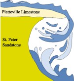
The falls continued to recede up the Mississippi to its current location in downtown Minneapolis (St. Anthony falls). The same type of erosion can be seen at nearby Minnehaha falls. From your vantage point at the confluence of the rivers, look across the Minnesota river and up the far bank. Note the limestone over sandstone wall just below the apartment building. That wall and the bluff upon which Fort Snelling sits were the edges of the mighty River Warren. The sandstone layer is white and soft and is the lithified (meaning made into rock) remains of the beaches of an Ordovician sea that covered all of the region 450 million years ago. The Platteville limestone atop the sandstone is more erosion resistant. It contains the fossils of snails and clams that lived on the floor of an ocean that covered the region 400 million years ago. Above the limestone layer is the modern soil.
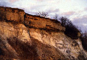
If you desire a closer look at this rock formation, there is a location along the Minnehaha trail between Fort Snelling and the Mississippi river that is very interesting. Enter the trail at N44 53.532, W93 10.763 and proceed northwest a short distance to a point under highway 5 (N44 53.613, W93 10.909). The sandstone is at ground level and the limestone cap is easily seen above.
The Glacial Erratic
A glacial erratic is a piece of rock that deviates from the size and type of rock native to the area in which it rests; the name "erratic" is based on the errant location of these boulders. These rocks are theorized to have been carried to their current locations by glacial ice. Erratics can range in size from pebbles to large boulders weighing many tons. They can be found many miles away from their place of origin. Geologists identify erratics by studying the rocks surrounding the position of the erratic and the composition of the erratic itself. Erratics were once considered evidence of a massive flooding.
In the 19th Century many scientists came to favor erratics being deposited by glacier activity rather than flooding. Geologists have suggested that landslides or rockfalls initially dropped the rocks on top of glacial ice. The glaciers continued to move, carrying the rocks with it. When the ice melted, the erratics were left in their present locations.
A short walk from the parking area across from the main park entrance is a good example of a glacial erratic boulder.
Go to N44 52.615, W93 11.523 - there you will find a boulder deposited by a glacier more than 10,000 years ago. Local Dakota have held ceremonies at this boulder. Large, mysterious rocks such as this one are considered by the Dakota to be "wakan" or sacred.
Claiming Credit for Visiting this Earthcache: To claim this find, you need to do a bit of geological research that involves evidence of an actual visit and some brainpower activity ensuing from that visit. I have a couple of suggestions:
You'll have to send me an email (paklid@gmail.com) in which you report on ONE of the following:
1. estimate the weight of the glacial erratic.
To do that, you will need to estimate the volume of the erratic (you'll need to visit it). Remember when you were sleeping in high school physics.... Well, the rest of the class learned that if you multiply volume by density you will get mass. Since we're all residents of earth, I will provide you with a "weight density" for typical granite (168 lbs/cubic foot). So if you multiply the volume by the "weight density" you will get pounds force (or weight).
2. Visit the confluence as described. It's worth the hike. I provided the average flow rate for both rivers in the text of this page. The experiment I would ask of you is to take a small piece of debris (keep it small, like a dead twig washed up on the beach) and toss it into the river. Estimate the speed of the current. Determine the river's width at the point where you measured the speed. Either mark a waypoint at river's edge and visit the other side and take a similar marking or simply employ google earth. With the speed, and the width, and the average flow rate, you should be able to estimate the river's average depth. Report that to me.
3. This is the simplest option. Estimate the speed of either river using the method described above and report that to me.
To get credit, you only need to do ONE of the three potential experiments described above. If you do more than one, you have my permission to move to the head of the class, but it's still just one "find".
Additional Hints
(Decrypt)
Most of the info for this cache was lifted from various websites. The pictures and some of the info came from the site that is linked at the top of this page.