Coastal Craze Earthcache EarthCache
-
Difficulty:
-

-
Terrain:
-
Size:  (other)
Please note Use of geocaching.com services is subject to the terms and conditions
in our disclaimer.
|
This Earthcache will focus on one of the most dynamic environments on earth…The Coast…. Where the Sea meets the Land.
|
|
|
| This cache is an exploration /driving tour highlighting features of NJ’s Geologic 130-mile Shoreline. Along our shores continental and oceanic processes converge, producing landscapes that are characteristically capable of rapid change. |
| There is no specific order that must be followed to complete this cache. |
| The posted coordinates are a suggested place to start. |
| To claim a find for this cache you must visit at least 10 of the posted locations. |
| To claim a find you must post: |
| • The name of each location visited. |
| • At least 1 photo for each of these geological features. |
| (Coastal Dune, Coastal Stream or Lagoon, Wave, Beach, and Littoral Drift) |
| • Describe in an email what you discovered at each site visited. |
| You may find these sites helpful: |
| New Jersey Coastal Heritage Trail Route & Costal Heritage Trail Maps |
|
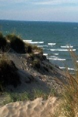
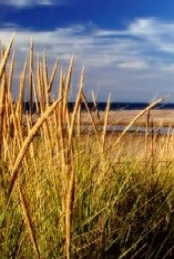
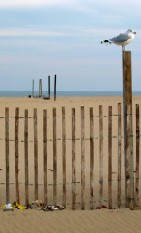
Coastal Dunes
|
| Coastal dunes are similar in many respects to the sand dunes one finds in the desert but with some significant differences. The main difference is the presence of water in the environment. Coastal dunes have a tendency to become vegetated. The presence of vegetation allows the dunes to become stabilized i.e. to stop migrating. As a result of this stability, people have a tendency to build things on the dunes or beside the dunes. A serious problem in many coastal dune areas is the destabilization of the dunes. When the dunes become destabilized they begin to move. |
| |
|
| Three things are needed to produce coastal dunes. |
| 1.) A plentiful supply of sand |
| 2.) a place to store the sand |
| 3.) strong and steady wind. |
| |
|
| Additionally, NJ has Easterly winds which tend to arise in the morning for most of the year and can blow 20 -40 miles per hour. |
| |
|
| A close examination of the dune sand reveals that it is typically finer than the sand found on the adjacent beach. Dunes are formed by the action of the wind, not by the action of waves as is the beach. When the wind blows strongly, the sand grains on the beach are picked up by the wind and transported onto the dune. There is a limit to the maximum size grain that the wind can transport. As a result, the wind tends to winnow the finer grains from the beach. |
| |
|
| In the long term the removal of sand from the beach to the dunes can constitute a net loss of beach sand from the coastal sand supply system. |
| |
|
|
|
|
Gateway National Park GNP |
| |
(N 40 25.575 W 073 58.956) -Click here for map |
| |
At the entrance to the NY, NJ Estuary, two arms of land stretch across the water towards one another. Together they form a natural gateway. One of these land arms is Sandy Hook, the NJ unit of GNP Sandy Hook State Park (N 40 27.943 W 073 59.950) |
| |
Island Beach State Park |
| |
(N 39 47.160 W 074 05.690) -Click here for map |
| |
Higbee Beach |
| |
(N 38 57.729 W 074 57.779) -Click here for map |
| |
Cape May State Park |
| |
(N 38 55.904 W 074 57.313) -Click here for map |
| |
Corsons Inlet State Park |
| |
(N 39 12.738 W 074 38.787) -Click here for map |
|
Coastal Streams and Lagoons
|
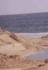
| Due to the relatively small size of the drainage basins and to the seasonal rainfall patterns, most of our coastal streams do not have high discharge except during storms. In fact, for most of the year, stream flow is fed by ground water seeping into the stream beds. As a result of this low flow regime, the waves will construct a sand bar across the mouths of the streams causing water to pond behind the beach. With stream discharge low, the streams do not have much competence, that is, they can usually transport only small particles. When these fine-grained particles reach the ponded area, they settle out and mud flats begin to accumulate. These mudflats are in turn colonized by vegetation and biologically-rich ecosystems eventually evolve. Periodically, large winter rainstorms cause the streams to swell and the bar is breached. This flushes or cleanses the lagoon. The waves can also breach the bar by over washing and eroding it. If the amount of water behind the bar is large, then release of this water can be very forceful and create a danger to persons in the area. |
| |
|
|
|
|
Hereford Inlet |
| |
(N 39 03.430 W 074 47.478) -Click here for map |
| |
Eno’s Pond |
| |
(N 39 49.955 W 074 10.741) -Click here for map |
| |
Cattus Island |
| |
(N 39 59.003 W 074 06.896) -Click here for map |
| |
Great Bay Blvd. Wildlife Management Area |
| |
(N 39 30.546 W 074 19.201) -Click here for map |
| |
Stone Harbor |
| |
(N 39 03.751 W 074 46.475) -Click here for map |
| |
Edwin Forsythe National Wildlife Refuge |
| |
(N 39 27.801 W 074 26.653) -Click here for map |
|
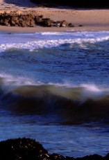
Wave
|
| Although terrestrial geologic processes do operate at the shoreline, the thing that distinguishes coastal geology is the dominant role played by waves as a geologic agent. Most of the waves you see are generated by the wind. In terms of the energy expended against the shoreline, the most significant waves are generated by storm winds. Waves tend to come in two distinct varieties. One type of wave is known as a sea. These are waves which are produced by local storms. They tend to be very chaotic and include a broad range of wave heights. The other types of waves are known as swells. These are waves produced by distant storms. Although they can be very large, they tend to be long and smooth and very consistent in size and period. Swell waves carry the energy of large storms over incredible distances. Some of the swells which expend their energy on our coast come from huge storms. The long term effect of wave energy is that waves tend to straighten the shoreline. |
| |
|
|
|
|
Barnegat Bay |
| |
(N 39 45.846 W 074 06.368) -Click here for map |
| |
Cape May |
| |
(N 38 56.663 W 074 58.201) -Click here for map |
| |
Holgate |
| |
(N 39 31.774 W 074 16.010) -Click here for map |
| |
|
| |
|
| |
|
| |
|
| |
|
| |
|
|
Beaches
|
| We could hardly talk about the geology of the coastal zone without talking about beaches. A beach is a collection of unconsolidated material deposited against the coastline by waves. Beaches can be made of a variety of materials. There are coral beaches, black beaches, green beaches, and even pink beaches. Each color is due to the predominance of different minerals in the beach deposits. Many beaches around the world, our own beaches included, are formed predominantly by grains of quartz and feldspar. These minerals are very common in continental crust, for example, in rocks like granite. Over time, these rocks, exposed at the earths surface, weather and break down into their constituent mineral grains. These grains, along with other rock fragments, are washed by runoff into the streams where they are eventually carried to the sea. Once at the shoreline, the coarser grains are distributed along the shore by waves. The finer material is washed out to sea where it eventually settles to the bottom in quieter, deep-water environments. In addition to being geologically interesting, beaches are important for other reasons. One is as a recreational resource. Beaches are one of those environments which people seem to gravitate to naturally. I don't think I have to belabor the point. Another reason is that beaches act as buffers to attack of the coast by storm waves. In many cases, it may take several storms before enough sand has been removed from the beach to allow the waves to seriously batter the cliffs or dunes. |
| The presence of beaches and their width play a very important role in determining rates of coastal erosion. |
| |
|
|
|
|
Atlantic City |
| |
(N 39 21.538 W 074 25.074) -Click here for map |
| |
Ventnor |
| |
(N 39 20.405 W 074 20.362) -Click here for map |
| |
Margate |
| |
(N 39 19.254 W 074 30.693) -Click here for map |
| |
Point Pleasant Beach |
| |
(N 40 04.004 W 074 02.985) -Click here for map |
| |
Normandy Beach |
| |
(N 40 00.160 W 074 03.516) -Click here for map |
| |
Highlands |
| |
(N 40 23.153 W 073 59.100) -Click here for map |
|
Littoral Drift
|
| Although terrestrial geologic processes do operate at the shoreline, the thing that distinguishes coastal geology is the dominant role played by waves as a geologic agent. Most of the waves you see are generated by the wind. In terms of the energy expended against the shoreline, the most significant waves are generated by storm winds. Waves tend to come in two distinct varieties. One type of wave is known as a sea. These are waves which are produced by local storms. They tend to be very chaotic and include a broad range of wave heights. The other types of waves are known as swells. These are waves produced by distant storms. Although they can be very large, they tend to be long and smooth and very consistent in size and period. Swell waves carry the energy of large storms over incredible distances. Some of the swells which expend their energy on our coast come from huge storms. The long term effect of wave energy is that waves tend to straighten the shoreline. |
| |
|
|
|
|
Longport |
| |
(N 39 18.153 W 074 32.068) -Click here for map |
| |
Sea Bright (Navesink) |
| |
(N 40 23.403 W 073 58.433) -Click here for map |
| |
Ocean City |
| |
(N 39 16.781 W 074 33.612) -Click here for map |
| |
Strathmere |
| |
(N 39 11.346 W 074 39.765) -Click here for map |
| |
Mantoloking |
| |
(N 40 02.374 W 074 02.929) -Click here for map |
| |
|
| |
|

If you have any comments or if this cache need attention, please email us by clicking HERE
Additional Hints
(Decrypt)
Uvag Nf lbh rkcyber AW’f fuberyvarf, yrg lbhe vzntvangvba tb jvyq naq gel gb raivfvba jung guvf ynaq ybbxrq yvxr jura gur Rhebcrna frggyref neevirq jvgu Urael Uhqfba. "Va rirel bhgguehfg urnqynaq, va rirel pheivat ornpu, va rirel tenva bs fnaq gurer vf gur fgbel bs gur rnegu." Enpury Pnefba Rkgen perqvg: Ghpxregba Frncbeg (A 39 36.106 J 074 20.576)