The above coordinates are NOT for the cache but for the trailhead of Deep Creek Trail. This trail is on National Park Service property but the cache is not. At no time will you have to leave the trails to find the information needed in order to find the final cache.
From downtown Bryson City, NC, follow the signs to Deep Creek Campground. Continue past the campground entrance (don't take the bridge across the creek) to the hiker parking area at the end of the road. Deep Creek Trail is the old road that starts at the far end of the hiker parking area.
This hike -- a tad on the strenuous side -- will take you over five different bridges. Your task is to count the number of vertical support beams holding up the railings on each bridge. You only need to count the vertical supports on one side of each bridge. (For example, if one bridge has four vertical supports on each side the number you need is four not eight.) And if there are different numbers on each of the two sides of the bridge, use the downstream vertical supports.
Bridge One Vertical Supports: ____________
Bridge Two Vertical Supports: ____________
Bridge Three Vertical Supports: ____________
Bridge Four Vertical Supports: ____________
Bridge Five Vertical Supports: ____________
Bridge Six is actually Bridge One.
About 0.7 miles from the trailhead you will come to an intersection. The numbering I have used above assumes a clockwise walk around the loop trail. So continue straight ahead across Bridge Two. Do NOT turn right onto Indian Creek Trail unless you keep track of the bridges 2-5 in reverse direction.
The coordinates of the physical cache are:
N 35° 26.ABC
W 83° 26.DEF
A = Bridge 2 - Bridge 5
B = Bridge 3 - Bridge 5
C = Bridge 3 + Bridge 4 - Bridge 1
D = Bridge 4 + Bridge 5 - Bridge 3
E = Bridge 1 - Bridge 2
F = Bridge 1 - Bridge 4
CHECKSUM: A + B + C + D + E + F = XY; X + Y = 7
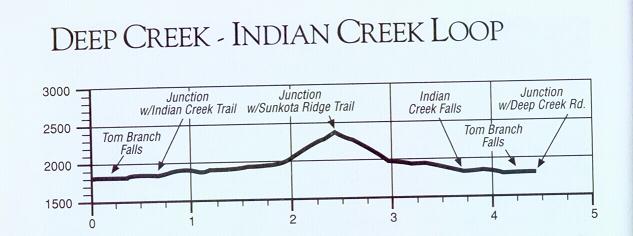
I have uploaded a map of the trail as well as a trail profile chart. One section of the trail has about a 500 foot gain in elevation in half a mile. It is not too steep; expect minor whining from kids eight years of age and younger.  Once at the top of the ridge by the start of the Sunkota Ridge Trail it is all downhill. Don't forget to check out Indian Creek Falls just after Bridge Five.
After walking the loop trail and performing the complicated mathematical computations you will be searching for a small spice bottle. If you are having problems finding the cache try subtracting 0.004 from the latitude and adding 0.001 to the longitude. Access to the cache is from within the county park. Do NOT attempt to access the cache from a road or private driveway!! Enjoy!
FTF HONORS GO TO PuzzlerNC and twinnies!!!