To take the tour, park close to N 43°12.738' W 82°01.351 and follow the path that leads below the point. Follow the path and visit the following locations:
- N43°12.736' W82°01.377
- N43°12.731' W82°01.377
- N43°12.724' W82°01.381
- N43°12.718' W82°01.381
|
To log this cache as a find, visit each waypoint and e-mail me the corresponding picture letter. E.G. 1 = A, B, C or D; 2 = etc. AND include in your email your estimate of the diameter of the largest concretion that you can find in the area. You can download these waypoints as well as the location of the largest concretion from the additional waypoint list.
|
370 million years ago you would have been standing in a warm shallow sea, in a tropical climate, close to the equator. Layers of mud settling to the bottom of the sea, containing the remains of creatures and plants, eventually became the shale that you can see around you. The "Kettle" concretions (Latin - concrescere = grow together) were formed, while the layers of mud were still soft, by precipitation of calcite (calcium carbonate). As the crystals of calcite grew they pushed away the surrounding mud. Over time, the mud became buried and dried out and the concretions stopped growing. Here, at Kettle Point, erosion of the shale has exposed the concretions and you can see them as they appear from the shale as well as completely exposed on the shoreline and for some distance out on the shallow reef in what is now Lake Huron.
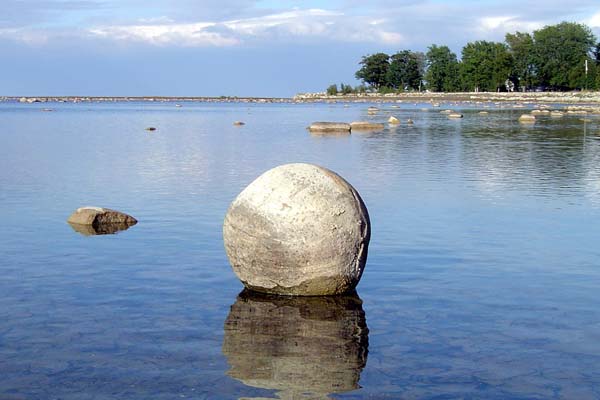
Such large spherical concretions are rare but similar, more recently formed ones, can be seen in New Zealand where they are called the Moeraki Boulders.
|
|
|
|
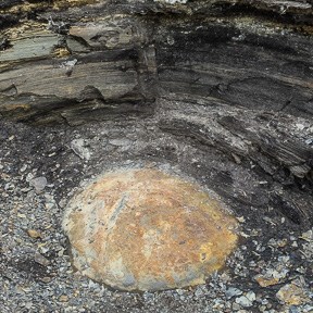
PICTURE A
Kettle concretions appear as the shale erodes. See how the shale folds around the concretion showing that it grew while the mud was soft. The dark colour is due to organic matter in the shale and is a source of the crude oil found locally.
|
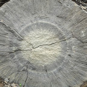
PICTURE B
This kettle is split and shows the internal structure. Fibrous crystals of calcite radiate from the centre. The coloured rings of calcite result from growth under different conditions. Look for the rusty cracks on the surface. Iron sulphide (marcasite) was also precipitated and small (2=3 cm) marcasite concretions can also be found in the shale.
|
|
|
|
|
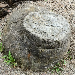
PICTURE C
Some of the kettles grew as doubles or triples. This one looks like a new concretion grew on top of an earlier one. Erosion or human activity has removed the second concretion
|
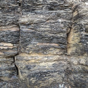
PICTURE D
The shale is jointed and split into large rectangular slabs. Note the finely laminated structure. Out in the lake, where the shale has completely eroded, the underlying limestone is similarly jointed and appears like giant paving stones
|
On a calm day a canoe or kayak is a great way to further explore the kettles in the shallows of the lake. You can park and launch from the beach at N 43°12.661' W 82°00.565'. See below for more pictures of kettles you can see out on the reef although these were taken when the lake level was much lower.
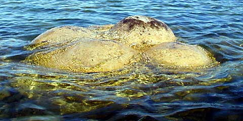
Multi-Concretion or sea monster?
This could be something from outer space!
