UpToTheSky Multi-cache
-
Difficulty:
-

-
Terrain:
-

Size:  (regular)
Please note Use of geocaching.com services is subject to the terms and conditions
in our disclaimer.
Dieses Cache bringt dich wieder einmal in die Höhe und vorallem
auf einen faszinierenden Berg.
Mit Auto oder Postauto gehts hoch nach Amden und weiter bis zum
Parking in Arvenbühl (ca 1200 müM). Von hier zu Fuss immer Richtung
'Leistchamm' ganz hoch bis auf 2101 müM auf den Leistchamm
zu den angegebenen Koordinaten.
Zeitbedarf für den ganzen Cache vom Auto und wieder zurück ist ab
3.5 Stunden aufwärts.
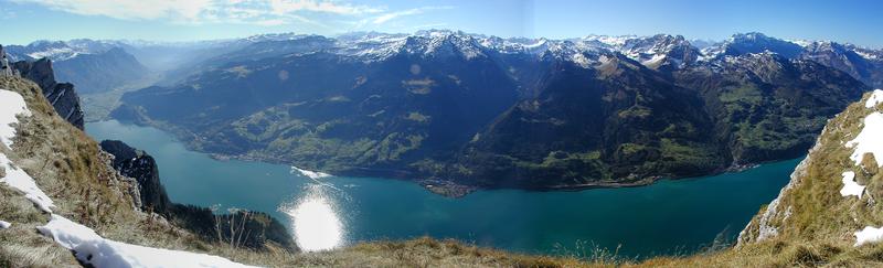
Faszinierend ist am Leistchamm vorallem, dass er von hinten sehr
einfach zu begehen ist. Dabei hat man im Schlussaufstieg ständig
das Gefühl in den Himmel zu laufen. Und dann ist man plötzlich oben
und auf der anderen Seite geht es praktisch senkrecht bis zum 1600
Meter tiefer gelegenen Walensee hinunter.
Da es auf dem Gipfel nicht viel Platz hat und ich niemanden zum
Herumklettern animieren möchte ist das Cache ein rechtes Stück
weiter unten und kann auf dem Rückweg gehoben werden.
Folgende Aufgabe ist auf dem Gipfel zu lösen:
Wann wurde das Gipfelkreuz platziert?
Datum: ab.cd.efgh
Damit berechnen sich die Endkoordinaten:
u = a + c
v = b + c + d
x = e + g - a
y = h - a - e
Das Cache befindet sich bei
N 47° 09.uv9
E 009°12.xy6
gut geschützt in der Wurzel einer kleinen Baumkombination.
-----------------------------------------------------------
This Cache takes you once again high into the
mountains.
By car or public transport you can drive up to Amden and then to
the parking in Arvenbühl (about 1200 müM). Now you have to walk
always direction 'Leistchamm' all up until you reach at the
given coordinates the peak of Leistchamm at 2101 müM.
You will need from 3.5 hours upwards for your trip and back to the
car.
When arriving at the peak you will be on top of a 1600 meters
vertical wall all down to the Walensee. An impressive view.
There is not much space on the peak, and I dont want anyone to
climb into the wall. This is why the cache itself is placed quite
some way back on your track to the car.
You have to solve the following riddle:
On which day was the cross at the given coordinates
placed?
Date: ab.cd.efgh
This is all you need to calculate the cache
coordinates:
u = a + c
v = b + c + d
x = e + g - a
y = h - a - e
Now you can look for the cache at:
N 47° 09.uv9
E 009°12.xy6
where it is well protected in the roots of a little tree
combination.
Additional Hints
(No hints available.)