De geschiedenis van Monnickendam begint rond 1235 als Friese
Norbertijner monniken zich vestigen op Marken. Van daaruit wordt
land ontgonnen en een nevenvestiging gesticht (het latere klooster
Mariëngaarde) welke mede tot het ontstaan van Monnickendam
leidde.
Parkeer uw auto op het kleine parkeerterrein met bovengenoemde
coördinaten. (Als het parkeerterrein vol is kunt u nog even
doorrijden voor meer parkeerplaatsen.) Loop vervolgens naar:
N 52°27.437 - E 005°02.318
U bent hier bij de oude Joodse begraafplaats. Een aantal
grafstenen heeft een zwarte rand. (Het is niet nodig om de
begraafplaats te betreden.)
A = het aantal naast elkaar geplaatste grafstenen met een
zwarte rand (die ene losse telt dus niet mee!)
Loop verder naar:
N 52°27.(AAA+82) - E 005°02.(AAA-169)
Binnen een straal van 25 meter treft u hier drie bruggen aan.
Een van deze bruggen is een voetgangersbrug met witte
leuningen.
B = het aantal planken waaruit het loopgedeelte van deze
brug bestaat
Blijf het pad volgen op weg naar:
N 52°27.(AAA+76) - E 005°01.9B
U bent hier bij de Grote of Sint Nicolaaskerk. Veel verzakkingen
hebben de kerk in de loop der tijd geteisterd. De toren dateert uit
1550. In de toren hangt een luidklok.
C = de hoogte van de tweede omloop in meters
D = de doorsnede in centimeters van de luidklok
Loop door de Zarken en de Kerkstraat naar:
N 52°27.((DxA)-8) - E 005°02.(0C+(Ax10))
Let vooral eens op de oude huizen en mooie gevelstenen in deze
straat.
Op nummer 32 is een gevelsteen gemetseld met daarop het jaar
waaruit dit pand dateert.
F = het jaar volgens de gevelsteen
Vervolg de wandeling naar:
N 52°27.(((A+B+C+D)x2)+B+50) - E
005°02.((F/10)-14)
Hier staat de al meer dan 400 jaar oude Speeltoren. Deze toren
heeft een uurwerk en een carillon.
G = het aantal klokken en klokjes van het carillon.
Loop nu door het Noordeinde, in noordelijke richting. Ook hier
vele mooie gevelstenen. Stop bij:
N 52°27.((CxG)+22) - E 005°02.(D-B-B-1)
Een van de mooie gevelstenen toont "Corneles Pieters, schypper
an 't roer".
H = het huisnummer van het pand met deze gevelsteen
Loop nog even verder in noordelijke richting en ga dan
naar:
N 52°27.((F-1000)-(A+A)) - E 005°02.((HxA)+2)
Naast de brug staat een beeld van een visser die zijn paling
gaat roken.
J = het aantal palingen
Nu verder naar:
N 52°27.(((G+H+J)xJ)+B+1)) - E
005°02.(((C-A)xJ)+2)
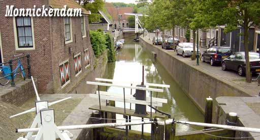
U bent hier bij de Damsluis. De eerste houten versie stamt al
uit 1420, maar nadien is de sluis nog vernieuwd en gerestaureerd.
Op de sluisdeur staat een groot jaartal met daarnaast een slecht
leesbaar ANWB-bordje. Het grote jaartal wijkt 1 jaar af van het op
het bordje vermelde jaartal waarop de sluis voor het laatst is
gerestaureerd.
19KL = het jaar waarop de sluis voor het laatst is
gerestaureerd volgens het ANWB-bordje.
U heeft nu alle gegevens verzameld die nodig zijn om op zoek te
gaan naar de cache. Deze is verstopt bij de volgende
coördinaten:
N 52°B.(((Dx(J-A))+LK) - E 005°02.((DxJ)+A+J)
Veel succes!
* * * * * * *
Bezoek ook de andere caches uit de Waterland-serie:
Waterland cache 1: Het Paard van Marken
Waterland cache 2: Broekje
Waterland cache 5: Landelijk Noord
Waterland cache 6: Edam, niet alleen kaas
This is the third of the number of
caches in the Waterland area. A short (4 km) and easy walk through
the historical village of Monnickendam.
Park your car at the car park with the
above mentioned coordinates. (There are more car parks down the
road.) Then walk to:
N 52°27.437 - E 005°02.318
You are here at the old Jewish
cemetery. A number of headstones has a black border. (It is not
necessary to enter the cemetery.)
A = the number of aligned
headstones with a black border (don't count the single one in the
back)
Walk on to:
N 52°27.(AAA+82) - E 005°02.(AAA-169)
Within a distance of 25 metres you will
find three bridges. One of the bridges is for pedestrians only and
has a white railing.
B = the number of planks in the
walkingpart of this bridge
Follow the footpath and go to:
N 52°27.(AAA+76) - E 005°01.9B
Now you are near the Grote or Sint
Nicolaas church. Watch the sagging of the churchwalls. The tower
dates back to 1550. In the tower is a bell
("luidklok").
C = the height of the second
gallery in metres ("hoogte 2e omloop")
D = the diameter of the bell in centimetres
("doorsnede")
Walk through Zarken and Kerkstraat to
:
N 52°27.((DxA)-8) - E 005°02.(0C+(Ax10))
Mind the many old houses with beautiful stone tablets in this
street.
Number 32 has a stone tablet showing
the year of construction of this house.
F = the year of
construction
Continue to:
N 52°27.(((A+B+C+D)x2)+B+50) - E
005°02.((F/10)-14)
Here you will find the old Playing
tower ("Speeltoren"). This tower has a clock ("uurwerk") and a
carrilon.
G = the total number of clocks
of the carillon ("klokken", "klok" and "klokjes").
Now walk through Noordeinde, in
northern direction. Here are some beautiful stone tablets too. Stop
at:
N 52°27.((CxG)+22) - E
005°02.(D-B-B-1)
One of the stone tablets shows
"Corneles Pieters, schypper an 't roer" (Cornelis, the son of
Pieter, as a skipper, handling the rudder).
H = the address (house number)
of the house with this stone tablet
Walk a little more in northern
direction and then go to:
N 52°27.((F-1000)-(A+A)) - E
005°02.((HxA)+2)
Next to the bridge there is a statue of
a fisherman smoking his eel.
J = the number of
eel
Now continue to:
N 52°27.(((G+H+J)xJ)+B+1)) - E
005°02.(((C-A)xJ)+2)
You have reached the Dam lock
("Damsluis"). The first wooden version dates back to 1420, but
later it was renovated several times. On the door of the lock a big
number is visible. This is the year of the last restauration. Next
to this year a small sign is placed. It is hardly readable. This
sign (in Dutch) shows information about several restaurations. The
last mentioned year is the year of the last restauration, but it is
not the same year as the big white number. There is a difference of
1 year.
19KL = the latest year of
restauration according to the small sign.
Now you have all the information you
need to find the cache. It is hidden near the following
coordinates:
N 52°B.(((Dx(J-A))+LK) - E
005°02.((DxJ)+A+J)
Good luck!