Napoleonsteine/Napoleon stones Multi-cache
Napoleonsteine/Napoleon stones
-
Difficulty:
-

-
Terrain:
-

Size:  (small)
Please note Use of geocaching.com services is subject to the terms and conditions
in our disclaimer.
The Cache is located at "Lobau" a very popular recreation area and part of the national park "Donau-Auen".
 In 1809 Napoleon was conquered by archduke Carl in this area. Tens of thousands were killed in action or were wounded during the battle of Aspern and Essling. In 1859 six memorial obelisk stones were positioned at the most prominent places as a reminder.More details about the national park area can be found at:
http://www.donauauen.at/ (multilingual).
I recommend to use a bike for the tour! Start at the U1 station "Donauinsel". (Additional 9 km (one way) alongside the Donauinsel to the starting point). Those who want to make the tour afoot take the U1 to "Kaisermühlen-VIC", and there the bus 91A till "Lobgrundstraße". The starting point is very close to this station. The trail is half of it`s length a tarmac walk the rest a gravel walk. An inn is very close to stage 6. No special equipment is needed. A map is very useful.
Length: 13.5 km (round-trip), no difference in height.
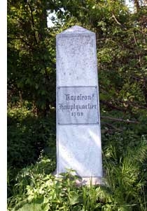
At the 6 given coordinates you will find an obelisk and a metal plate aside with an explanation.
Stage 1: The Bridgehead
N1 = 48° 10.698´
E1 = 016° 29.636´
Look for a date in the format dd.mmmm.yyyy. Take dd as A.
Stage 2: Napoleon's Headquarters
N2 = 48° 10.826´
E2 = 016° 29.446´
(The given coordinates of this stage may not be very accurate, but I'm sure you will find the obelisk.)
How many soldiers had Napoleon's army. Divide the result by 1000 and call it B. (If the board is missing try to get the information at the next stages.)
Stage 3: Napoleon Road
N3 = 48° 11.491´
E3 = 016° 30.139´
(The given coordinates of this stage may not be very accurate, but I'm sure you will find the obelisk.)
Look for a date in the format dd.mmmm.yyyy. Take dd as C.
Stage 4: French Cemetery
N4 = 48° 11.237´
E4 = 016° 31.714´
The dead french soldiers were burried here. How many? Divide the result by 1000 and call it D.
Stage 5: French Powder Room
N5 = 48° 11.288´
E5 = 016° 31.822´
Look for the first date on the plate in the format dd. Take dd as E.
Stage 6: French River Crossing Point
N6 = 48° x6´ where x6 = 10.895
E6 = 016° y6´ where y6 = 32.200
How many bridges were built in total? Take the result as F.
Stage 7: The Cache
Now you should be ready to calculate the final stage.
N7 = 48° x7´ where x7 = x6 - (A + B + C + 2 * F) / 1000
E7 = 016° y7´ where y7 = y6 - (5 * D + 2 * E + 2) / 1000
The cache (third edition) initially contained:
- cachenote (please don´t remove)
- logbook (please don´t remove)
- pencil (please don´t remove)
- trading items

Good luck and happy caching, PlanetEarth
Version 3.4
Additional Hints
(Decrypt)
Irel ovt gerr fghzc pybfr gb n ebnq. Rlr urvtug.