You will need to answer questions at the first four waypoints in order to determine the coordinates of the final waypoint. All the questions are multiple choice; choose the answer you think is correct, then record the number that follows it in parentheses. For example, if you choose "Ansel Adams (9)" as your answer to Question G, you would replace G in the final waypoint with "9".
There are also two questions for the final location, Waypoint 5. To confirm your completion of this geocache, please email me your answers to those questions.
All of the required waypoints are easily accessible by car or bike. (Or on foot, if you don't mind a lot of walking!) During busy times of the year you may not be allowed to park at the final waypoint, but there are parking areas not far away.
Because GPS readings can be very dicey in Yosemite Valley, be on the lookout for the waypoints well before you expect to get to them. Most of them are along one-way roads and it will take you quite a while to get back to the right place if you accidentally drive past one.
Feel free to post your photos of the first four waypoints (NOT the last one!), as long as they don't give away any of the answers to the questions.
Ready? Here we go!
Update July 21, 2018: I have modified a few questions to reflect slight changes on replaced signs, and to make the questions clearer for people who may not be native English speakers. All of the locations are the same as before, although I made a tiny change to one set of coordinates to make it clear which of two signs you need to read.
You can check your answers for this puzzle on Geochecker.com.
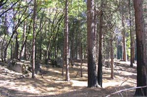
Waypoint 1: Glacial Moraine
N 37° 43.433 W 119° 38.673
Yosemite Valley is what it is today because of glaciers. You may already know how glaciers deepened and widened the original valley cut by the Merced River. But glaciers create other effects, too.
When a glacier melts, the rocks and dirt it holds are freed from the melting ice and left in place as the glacier retreats. The largest deposits--known as "moraines"--are along the edges of the glacier, including the front edge. In this first stage of Stories in the Rocks, you'll visit a moraine formed when the most recent glacier receded from the valley.
Waypoint 1 is a parking area off Northside Drive. After you park, cross the road (watch for oncoming cars!), and you'll be standing in front of a glacial moraine. It's a low, gentle ridge that you probably wouldn't normally even notice as you drive by, but it's evidence of dramatic events that took place at least 10,000 years ago. You can wander through the meadow in front of the moraine, or walk up and stand atop it. Face east and imagine a glacier filling Yosemite Valley from El Capitan back past Half Dome.
To answer Question A, look for a Bureau of Public Roads survey mark at the waypoint coordinates. Make sure you find the survey mark on the north side of the road, near the parking area and the wooden post marked "V7".
Question A
What is the last digit of the elevation on this survey mark? (The elevation is the number just before “FEET.”)
- 1 (1)
- 2 (2)
- 3 (3)
- 4 (4)
- 5 (5)
Waypoint 2: Hanging Valley
N 37°43.320 W 119° 38.930
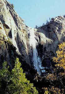
Millions of people enjoy the beauty of Bridalveil Fall every year. But do you know what created it?
Around 15 to 25 million years ago, friction between the Pacific and North American plates began pushing the earth's crust upward in eastern California, forming what we now know as the Sierra Nevada range. Streams and rivers were born, and as the tilt of Sierran region increased, the rivers ran faster and cut more deeply into the land.
Well before glaciers started arriving a million or more years ago, the Merced River had already created a narrow V-shaped gorge. As the river cut deeper and deeper, the smaller, slower-moving streams entering it from the side did not have enough water or momentum to cut through their bedrock at the same rate. These sidestreams were literally left hanging as the river they were joining dropped further and further below them. When glaciers came through Yosemite Valley, they made the side walls even steeper and cut the valley floor even deeper, stranding some sidestreams--including Bridalveil Creek--thousands of feet above the Merced River. And we're glad they did, because otherwise we wouldn't have the magnificent waterfalls for which Yosemite Valley is justly famous.
Waypoint 2 is an interpretive sign about hanging valleys in general and Bridalveil Fall in particular. Read the sign to answer the questions below.
Question B
Besides Bridalveil Fall, what are the similar waterfalls mentioned on the sign?
- Yosemite, Ribbon, and Sentinel Falls (3)
- Wapama, Ribbon, and Sentinel Falls (5)
- Ribbon, Illilouette, and Sentinel Falls (6)
- Sentinel, Illilouette, and Wapama Falls (9)
- Yosemite, Ribbon, and Illilouette Falls (2)
Question C
According to this sign, how high is Bridalveil Fall?
- 615 feet (0)
- 617 feet (3)
- 620 feet (8)
- 618 feet (4)
- 625 feet (5)
Question D
What natural feature or action is not mentioned on this sign?
- Glacial ice (5)
- Hanging valley (2)
- Glacial headwaters (7)
- Tributary valley (6)
Waypoint 3: Granite Giant
N 37° 43.218 W 119° 38.943
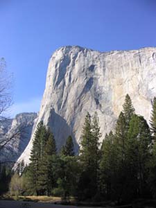
El Capitan is one of the world's largest monoliths. A renowned destination for rock climbers, it's also a great example of Yosemite geology. If you look at it with binoculars, you'll see not only the obvious light-grey rock, but also whitish veins and streaks and splotches of various colors.
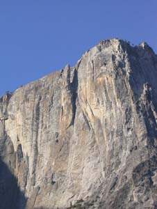
(This waypoint gives you a view of the western side of El Capitan. When you get to the eastern side, be sure to look for one of the most interesting variations in the coloring of this monolith. It's a dark area that resembles a map of North America; you can see it in the photo here. This feature was formed far beneath the surface of the earth when molten rock intruded into the cooling granite that would later become El Capitan. Now, 100 million years later, it's out in the open for you to admire. :-) )
There are two interpretive signs at this waypoint. One of them has the answers to the questions below.
Update December 18, 2021: Thanks to Lookin4U for letting me know that Waypoint 3 is currently inaccessible due to construction. I'm temporarily revealing the answers for this waypoint, which are E: Volcanism and F: 3,000 feet.
Question E
Which type of geologic process is not mentioned on the sign?
- Glaciation (8)
- Volcanism (4)
- Erosion (3)
- Rockfalls (1)
- Earthquakes (6)
Question F
According to this sign, how deep was Yosemite Valley at the onset of the Ice Age?
- 1,000 feet (3)
- 4,000 feet (7)
- 7,000 feet (0)
- 8,000 feet (4)
- 3,000 feet (2)
Waypoint 4: Solo Spire
N 37° 44.659 W 119° 35.341
Yosemite Valley changes constantly--and some of the biggest changes have been made by plain old water acting slowly but surely over the millennia. Every winter, freezing water gets into joints in the rocks, freezes, and expands. Eventually, such repetitive action (called "mechanical weathering") can cause pieces of rock to break apart and fall off. Depending on the structure of the rock, this shedding can take various forms. You'll see one form at this waypoint, and another at the final waypoint.
Lost Arrow is a dramatic granite spire to the right of Yosemite Falls. Its base is still connected to the north wall of Yosemite Valley, but the upper part of the spire stands apart from the wall because the less resistant rock in between has fallen away due to mechanical weathering.
Waypoint 4 is an interpretive sign about Lost Arrow. Read the sign to answer the questions below.
Question G
Who is the source of the quote on this sign?
- Ansel Adams (9)
- Stephen Mather (4)
- John Muir (7)
- Theodore Roosevelt (6)
- Josiah Whitney (2)
Question H
How many photos are in the lower right part of the sign?
- 1 (1)
- 2 (2)
- 3 (3)
- 4 (4)
- 5 (5)
Waypoint 5: Exfoliation in Action
Okay, you're almost done! Use the answers you've gotten at the first four waypoints to find the coordinates of the final waypoint.
N 37° 4A.BCD W 119° 3E.FGH
At Waypoint 4, you saw one way in which mechanical weathering (the action of water freezing and expanding winter after winter) can act upon rock. At this final waypoint, you'll see another dramatic effect, known as exfoliation.
Exfoliation is a process that strips off rock in sheets, like peeling the layers of an onion. Sometimes the sheets are flat, but even more elegant are the ones that form concentric shells. If you look in the right direction from this waypoint, you'll see a dome and a wall of arches. Both the dome and the arches gained their striking rounded forms because of exfoliation.
To confirm your completion of Stories in the Rocks, please email me answers to the following questions:
Question 1
If you face west from this spot, what does the large brown-and-white sign say?
Question 2
If you face east from this spot, what does the large brown-and-white sign say?
I hope you've enjoyed this brief geological tour of Yosemite Valley! If you'd like to learn more about the natural history of this area, I highly recommend The Geologic Story of Yosemite National Park by USGS geologist Dr. N. King Huber. This fascinating, 60-page book features text, photos, and diagrams that make the complex geologic history of Yosemite easily accessible to laypeople.