ENGLISH
A route by the Lake of bouilloses.
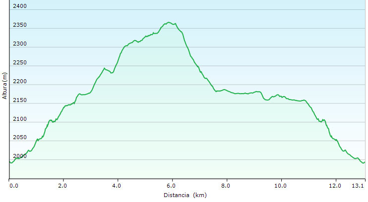
It is an excursion of all the day, 5 to 6 hours. You take's the lunch. You will visit 13 lakes of high mountain and magnify views of the Pyrenean.
The excursion begins the lake of bouilloses (between Font Romeu and Les Angles), a lake of great dimensions. In winter to accede is almost impossible, is recommendable to do it when there isn't snow. You must leave car past the prey, there is a hotel.
Normally in summer there is a navete service until the lake. It is cost 5€. The circulation with car is cut at 7h to 20h.
The way begins at 42º33.599N 1º59.770E to 2038 meters. You must bring paper and pen to point the value of the letter. You must have attention of not being seen by another people, is a very popular way.
The route will be: llac de les bouillouses, Estany del Viser, Estany de les Dugues, Estany de Castellà, Estany d'en Gombau, Estany de Trebens, Estany de Sobirans, Estany de Vallell, Estany Llong, Estany Llat, Estany de la Comassa, Estany Sec, Estany Negre.
It is not long route (it's very easy to walk) but must dedicate his time.
N 42° AB.CDE' E 1°FG.HIJ'
CATALÀ
Un recorregut pels llacs de les Bouillouses.
És una excursió de tot el dia, entre 5 i 6 hores. Porteu-vos el dinar. Al llarg d'aquesta excursió visitareu 13 llacs d'alta muntanya i magnífiques vistes dels Pirineus. L'excursió parteix del llac de les Bouillouses (entre Font Romeu i les Angles), un llac de grans dimensions. A l'hivern l'accés és quasi impossible així que és recomanable fer-ho quan ja no hi hagi neu. Podeu deixar el cotxe passat la presa, hi ha un hotel.
Normalment a l'estiu posen un servei de "Navetes" que et porten fins el llac, a un preu de 5€. La circulació amb cotxe està tallada de 7 a 20 hores.
El camí comença a 42º33.599N 1º59.770E a 2038 metres. És recomanable portar paper i bolígraf per apuntar les dades que hi ha als múltiples caches. Tingueu la precaució de no ser vistos per altra gent, ja que és un camí força visitat.
El recorregut que seguireu serà: llac de les Bouillouses, Estany del Viser, Estany de les Dugues, Estany de Castellà, Estany d'en Gombau, Estany de Trebens, Estany de Sobirans, Estany de Vallell, Estany Llong, Estany Llat, Estany de la Comassa, Estany Sec, Estany Negre.
No és un gran recorregut (és molt fàcil de fer) però s'ha de dedicar el seu temps.
N 42° AB.CDE' E 1°FG.HIJ'