|
Raised Beaches, definition:
A raised beach, coastal terrace, or perched coastline is a relatively flat, horizontal or gently inclined surface of marine origin, mostly an old abrasion platform which has been lifted out of the sphere of wave activity. Raised beaches are also known as marine terraces, perched coastlines, and coastal terraces.
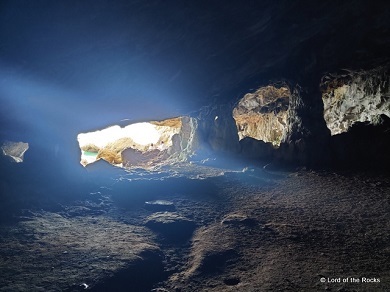
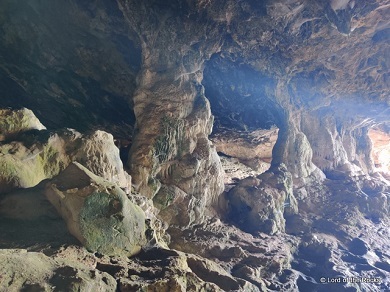
The Cave of Santa Margarida
The cave of Santa Margarida is located at the foot of the Arrábida mountain massif, on the southern slope, between Alpertuche and Portinho Beaches, on cliffs excavated by the sea in the Pleistocene, in an area currently represented by conglomerates from marine terraces of 12-15 and 5-8 meters, resulting from the last interglacial and the beginning of the Wurm glaciation - 100,000 Years, Tirrenian II and III (J.Pais and P.Legoinha, 2000). Currently, the difference in level of the cave to sea level should be between 5 meters.
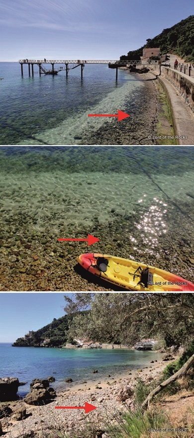
Current day evidences for conglomeratic levels:
Walking in any of the nearby beaches or along the rocky coast will show several levels of rounded clast accumulation, as in the images below:

The Cave of Santa Margarida preserves, at its entrance from the sea, a terrace of this nature. The terrace is easily identified by its rolled clasts cemented together.
The way to record this EarthCache is to answer the following questions:
Question 1 - Are the visible clasts on the floor millimetre-, centimetre- or metre-size?
Question 2 - Are the clasts spherical or oblate?
Question 3 - What is the size range of these clasts (on their longest axis)?
Question 4 - Look for evidence of the interior of the clasts. Is the inner material the same as its outer material?
The palcing of photos in teh logs is welcomed as long as they do not reveal, or aid in answering, the answers. Any logs with spoilers will be deleted.
Send me your answers to these questions to which I will respond only in the case of their being wrong. Enjoy the cache!
|
Praia Elevada, definição:
Uma praia elevada, terraço costeiro ou litoral empoleirado é uma superfície relativamente plana, horizontal ou levemente inclinada de origem marinha, principalmente uma antiga plataforma de abrasão que foi retirada da esfera da atividade das ondas. As praias elevadas também são conhecidas como terraços marinhos, costas empoleiradas e terraços costeiros.
A Lapa de Santa Margarida
A Lapa de Santa Margarida, situa-se, no sopé do maciço da serra da Arrábida, na encosta Sul, entre a Praia de Alpertuche e o Portinho, em arribas escavadas pelo mar no Plistocénico, numa zona actualmente representada por conglomerados provenientes de terraços marinhos de 12-15 e 5-8 metros, resultantes do último interglaciário e ao princípio da glaciação de Wurm - 100.000 Anos, Tirreniano II e III (J.Pais e P.Legoinha, 2000). Actualmente, o desnível da gruta ao nível do mar deverá situar-se entre os 5 metros.
Evidências actuais de niveis conglomeráticos
Um passeio à beira mar na zona revela uma quantidade imensa de clastos rolados e soltos, tal como nas imagens infra:
A Lapa de Santa Margarida preserva, na sua entrada pelo mar, um terraço desta natureza. O terraço é facilmente identificado pelos seus clastos rolados e cimentados uns com os outros.
A forma de poderem registar esta EarthCache é responder às seguintes perguntas:
Pergunta 1 - Os clastos visíveis no chão são millimétricos, centimétricos ou métricos?
Pergunta 2 - Os clastos são esféricos ou oblatos?
Pergunta 3 - Qual a gama de tamanhos destes clastos (no seu eixo mais longo)?
Pergunta 4 - Procurem evidências do interior dos clastos. O material interior é igual ao do seu exterior?
A colocação fotos nos registos é permitida desde que não divulgue, ou que ajude a responder às perguntas, as respostas a estas perguntas. Registos com Spoilers serão apagados.
Enviem-me as vossas respostas a estas perguntas às quais responderei apenas no caso de estarem erradas. Divirtam-se!
|