Il s’agit d’une earthcache : pour valider votre trouvaille, envoyez-moi vos réponses aux questions ci-dessous par la messagerie geocaching ou par mail. Tout log sans envoi des réponses est susceptible d’être effacé.
This is an earthcache: to validate your find, send me your answers to the questions below by geocaching messaging or by email. Any log without sending responses is likely to be deleted.
Note : le GPS est peu précis dans ce relief très encaissé. Suivez le balisage et arrêtez vous lorsque vous passez sous le pont : toutes les réponses peuvent être trouvées à cet endroit.
Note: the GPS is not very precise in this very deep terrain. Follow the markings and stop when you pass under the bridge: all the answers can be found here.
____________________________________________________________________
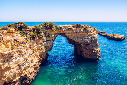
Une arche naturelle ou un pont naturel est une formation géologique constituée d’une arche rocheuse creusée par l’érosion.
A natural arch or a natural bridge is a geological formation made up of a rocky arch carved out by erosion.
Est-ce un PONT ou une ARCHE ?
Tous les ponts naturels sont des arches naturelles mais l’appellation « Arche » ou « Pont » dépend de la nature de l’érosion qui a formé l’arc.
On appellera « pont » une arche si :
- un cours d’eau a été à l’origine de sa formation
- un cours d’eau passe actuellement dessous
- les humains l’utilisent ou l’ont utilisé comme pont
- il a la forme caractéristique d’un pont construit (plat dessus et arqué en dessous)
Is it a BRIDGE or an ARCH?
All natural bridges are natural arches, but the designation "Arch" or "Bridge" depends on the nature of the erosion that formed the arch.
An arch will be called a “bridge” if:
- a watercourse was at the origin of its formation
- a stream currently passes below
- humans use it or have used it as a bridge
- it has the characteristic shape of a constructed bridge (flat above and arched below)
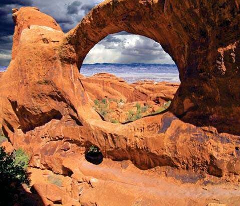
Comment se forme une arche ?
Différents types d’érosion peuvent entrer en jeu pour la formation d’arches :
L’érosion marine : lorsque le ressac frape la côte, les roches les plus friables sont usées plus rapidement que les roches dures. Celles-ci sont dégagées et peuvent former des arches.
L’érosion due aux changements de température : par exemple avec le gel/dégel de l’eau dans les failles, ou des changements liés aux très fortes chaleurs
L’érosion par les cours d’eau : l’eau érode plus facilement les couches de roche tendre, mettant à nu les couches plus dures. Ou bien, l’eau s’engouffre dans une fissure et l’agrandit petit à petit en érodant la roche sur laquelle elle coule mais pas celle qui se trouve au-dessus, ce qui finit par former une arche.
L’effondrement : le morceau de sol restant entre deux avens qui percent une galerie souterraine à peu de distance l’un de l’autre peut former une arche. Ce type d’érosion de rencontre uniquement en milieu karstique.
How is an arch formed?
Different types of erosion can come into play for the formation of arches:
Marine erosion: when the surf hits the coast, the most friable rocks are worn away more quickly than the hard rocks. These are clear and can form arches.
Erosion due to temperature changes: for example with freezing/thawing of water in faults, or changes linked to very high temperatures
Erosion by watercourses: water erodes soft rock layers more easily, exposing harder layers. Or, the water rushes into a crack and gradually enlarges it by eroding the rock on which it flows but not the one above it, which ends up forming an arch.
Collapse: the piece of soil remaining between two sinkholes that pierce an underground gallery a short distance from each other can form an arch. This type of erosion is found only in karstic environments.
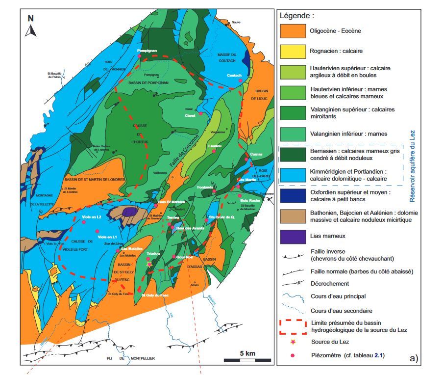
Le massif du Coutach
D’une superficie de 25km⊃2;, il s’étend de Sauve à Claret. Il s’est formé lors du jurassique supérieur et plus précisément au Kimméridgien et au Tithonien, soit entre – 157 et -142 millions d’années.
Le kimméridgien inférieur se caractérise par des petites couches (appelées bancs en langage géologique) de calcaire gris foncé. Il contient très peu de fossiles.
Le kimméridgien supérieur est formé de calcaires compacts à pâte fine en gros bancs gris ou beiges. Il forme souvent des falaises et des plateaux karstiques à nombreux lapiaz. Les fossiles y sont rares, même si quelques-uns ont été trouvés dans le massif du Coutach.
Le Tithonien est quant à lui formé de calcaires blanchâtres, de teinte plus claire que les précédents. De nombreux fossiles peuvent y être trouvés.
The Coutach massif
Covering an area of 25km⊃2;, it stretches from Sauve to Claret. It was formed during the Upper Jurassic and more precisely in the Kimmeridgian and the Tithonian, i.e. between -157 and -142 million years ago.
The Lower Kimmeridgian is characterized by small layers (called benches in geological language) of dark gray limestone. It contains very few fossils.
The upper Kimmeridgian is formed of compact fine-paste limestones in large gray or beige beds. It often forms cliffs and karstic plateaus with numerous lapiaz. Fossils are rare there, although some have been found in the Coutach massif.
The Tithonian is made up of whitish limestones, lighter in color than the previous ones. Many fossils can be found there.
Questions :
- Est-ce un pont ou une arche ?
- Quel type d’érosion est à l’origine de sa formation ?
- Placez-vous dans le trou sous l’arc et levez la tête. L’arc supérieur est au dessus de vous, mais à quelle hauteur ? Entre 1 et 3 mètres, entre 8 et 15 mètres ou entre 20 et 30 mètres ?
- Quelle est la nature de la roche qui compose l’arche ? Qu’est-ce qui vous permet de faire cette réponse ?
Optionnel : Prenez une photo de vous ou d’un objet vous représentant avec la vallée en fond et joignez là à votre log.
Questions :
1. Is it a bridge or an arch ?
2. What type of erosion caused it to form?
3. Stand in the hole under the arc and raise your head. The upper arch is above you, but how high? Between 1 and 3 meters, between 8 and 15 meters or between 20 and 30 meters?
4. What is the nature of the rock that makes up the arch? What allows you to make this answer?
Optional: Take a photo of yourself or of an object representing you with the valley in the background and attach it to your log.
Sources :
https://www.lostintheusa.fr/2016/03/02/difference-pont-arche-bridge-arch/
https://fr.wikipedia.org/wiki/Arche_naturelle
http://ficheinfoterre.brgm.fr/Notices/0938N.pdf