
La Earthcache / The Earthcache
► Contexte géologique local
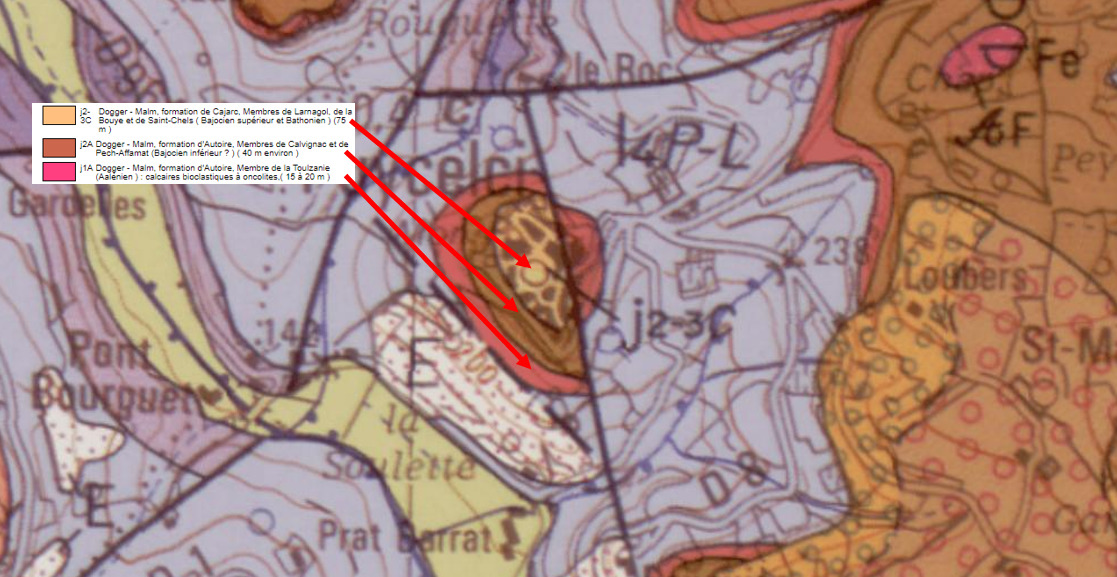
La cité fortifiée de Puycelsi prend place sur une butte témoin calcaire qui est entaillée par une faille normale (rejet supérieur à 50 m) mettant au contact la formation d'Autoire (Aalénien) et la base de la formation de Cajarc (Bajocien et Bathonien).
► Les formations de Puycelsi
~ Les Brèches dolomitiques de l'Aalénien
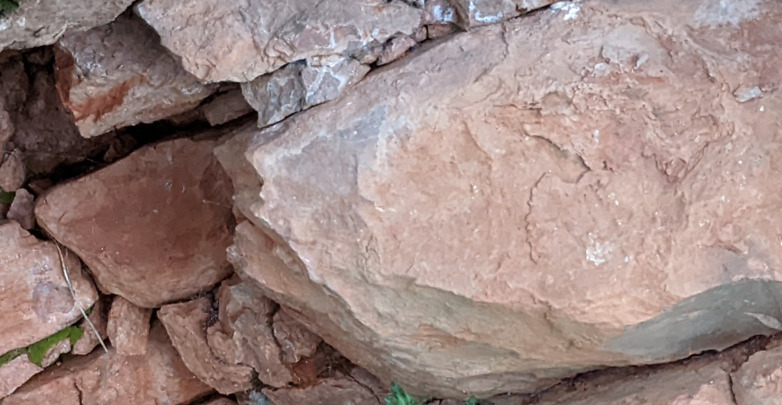
La formation la plus ancienne, celle de l'Aalénien, est faite de calcaires dolomitiques et de brèches issues de la dissolution de faciès d'évaporitiques.
Cette formation présente plusieurs particularités :
- Une disposition en strates (bancs bien délimités) avec un pendage faible (20 degrés maximum).
- Une surface durcie très oxydée donnant une coloration globale rouge prononcée.
- Une altération sous la forme d'argile riche en fer oxydée (traces rouges quand on frotte la roche).
~ Les calcaires oolitiques du Bajocien
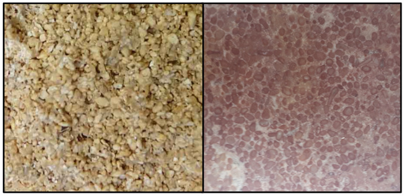
Nous sommes ici sur des calcaires sans stratification, clairs et formés d'oolithes cimentés.
Les oolithes se forment à faible profondeur dans des eaux chaudes.
Les vagues et courants mettent en suspension des fragments de coquilles autour desquels se cristallise du CaCO3 jusqu’à acquérir la forme de sphères millimétriques (oolithes).
La formation oolitique peut prendre différentes couleurs :
- Si le carbonate est pur, l'oolithe formée va être blanche.
- Si la précipitation du carbonate s'accompagne d'une précipitation ferrugineuse, la formation oolithique va prendre une couleur jaune à rouge selon la concentration de fer.
► Le Lapiaz, quand l'eau sculpte la roche
Le lapiaz est une formation karstique de surface dans les roches carbonatées (calcaires et dolomites) créée par la dissolution des carbonates sous l'action des eaux de ruissellement riches en CO2.
Se forment alors sur la surface calcaire des "rigoles de dissolution" plus ou moins marquées.
Ces rigoles s'initient de deux façon :
- soit à partir de diaclases initialement présentes dans la roche. elles sont alors pseudo-horizontales.
- soit le long de la ligne de plus grande pente par simple dissolution.

► Local geological context
The fortified city of Puycelsi takes place on a limestone witness mound which is notched by a normal fault (rejection greater than 50 m) bringing into contact the Autoire formation (Aalénien) and the base of the Cajarc formation (Bajocien and Bathonien).
► The formations of Puycelsi
~ The dolomitic breccias of the Aalenian
The oldest formation, that of the Aalenian, is made of dolomitic limestone and breccias resulting from the dissolution of evaporitic facies.
This course has several features:
- A layout in strata (well-defined benches) with a low dip (20 degrees maximum).
- A highly oxidized hardened surface giving a pronounced overall red coloration.
- Alteration in the form of clay rich in oxidized iron (red traces when the rock is rubbed).
~ Bajocian oolitic limestones
We are here on limestone without stratification, clear and formed of cemented oolites.
Oolites form at shallow depths in warm waters.
Waves and currents suspend fragments of shells around which CaCO3 crystallizes until it takes on the shape of millimetric spheres (oolites).
The oolitic formation can take on different colors:
- If the carbonate is pure, the oolite formed will be white.
- If the carbonate precipitation is accompanied by ferruginous precipitation, the oolitic formation will take on a yellow to red color depending on the iron concentration.
► The Lapiaz, when water sculpts the rock
Lapiaz is a surface karstic formation in carbonate rocks (limestone and dolomites) created by the dissolution of carbonates under the action of runoff water rich in CO2.
More or less marked "dissolution channels" then form on the limestone surface.
These channels are initiated in two ways:
- or from joints initially present in the rock. they are then pseudo-horizontal.
- either along the line of greatest slope by simple dissolution.
► Sources bibliographiques / Bibliographical sources
Les Questions / The Questions
Questions pour valider :"La butte témoin de Puycelsi"
Questions to validate: "The witness mound of Puycelsi"
- Question 0 : Prenez une photo de vous ou d'un élément vous appartenant dans Puycelsi.
Cette photo devra au choix nous être transmise avec les réponses ou être ajoutée à votre log.
-Question 0 : Take a picture of yourself or something belonging to you in Puycelsi.
This photo must either be sent to us with the answers or added to your log.
Point 1 : N 43° 59.494 E 001° 42.649'
Après vous être garé sur le parking le long de la route (voir point de parking), longez sur l'herbe la base des habitations dans le virage jusqu'à la photo WP1.
After parking in the car park along the road (see parking spot), walk along the grass along the base of the houses on the bend to photo WP1.
- Question 1 : Quelle est la couleur principale de la roche et quel en est l'élément à l'origine ? Si vous frottez vos doigts sur la roche, que se passe t-il ?
- Question 1: What is the main color of the rock and what is the element behind it? If you rub your fingers on the rock, what happens?
- Question 2 : La roche présente t-elle une stratification ? Si oui, estimez son inclinaison.
- Question 2: Does the rock show stratification? If so, estimate its inclination.
- Question 3 : En fonction de vos réponses précédentes, déduisez en la nature de la formation de Puycelsi à cet endroit.
- Question 3: Based on your previous answers, deduce the nature of the Puycelsi formation at this location.
Point 2 : N 43° 59.593 E 001° 42.691'
Suivez ensuite le chemin de ronde, sortez de la forteresse par la poterne et longez sur quelques dizaines de mètres le pied des murailles (photo WP2).
Then follow the walkway, exit the fortress through the postern gate and walk along the foot of the walls for a few tens of meters (photo WP2).
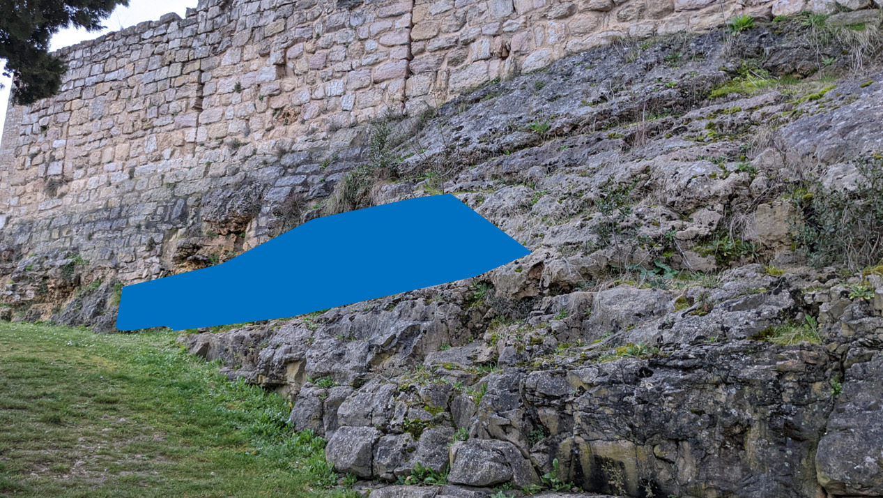
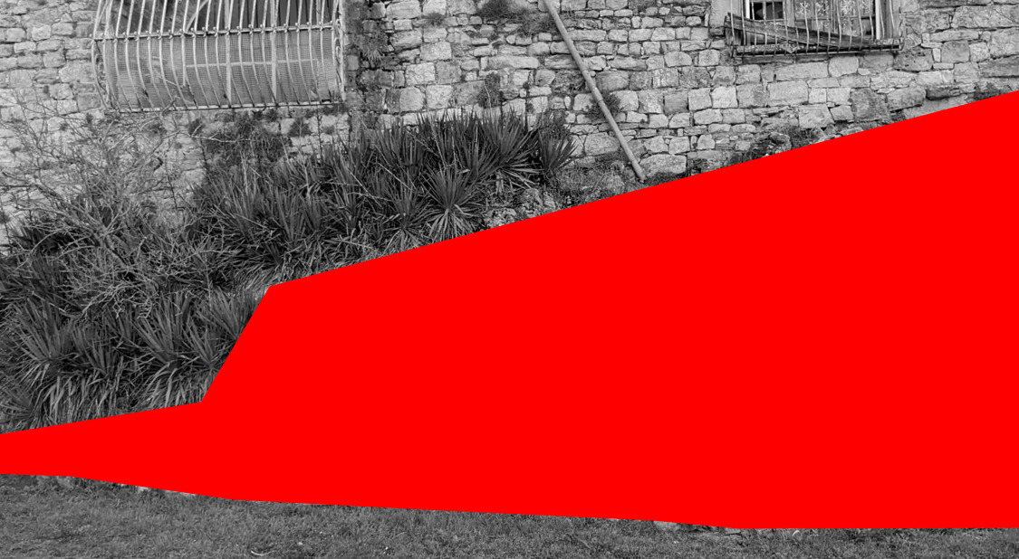
- Question 4 : Décrivez les formes d'altération de la roche sous la zone bleue. A votre avis quel est l'élément naturel qui en est à l'origine ? Comment s'appelle cette formation d'altération ?
- Question 4: Describe the weathering patterns of the rock below the blue area. In your opinion, what is the natural element that is at the origin? What is this weathering formation called?
Vous pouvez vous loguer sans attendre notre confirmation,
mais vous devez nous envoyer les réponses en même temps soit par mail via notre profil (
fafahakkai), soit via la messagerie geocaching.com (Message Center).
S'il y a des problèmes avec vos réponses nous vous en ferons part.
Les logs enregistrés sans réponse seront supprimés.You can log this cache without waiting for our confirmation, but you must send us the answers at the same time, by e-mail via our profile (fafahakkai) or by the system of Message Center of geocaching.com.
If there is a problem with your answers we will notify you. The logs recorded without answers will be deleted.
Rappel concernant les « Earthcaches »: Il n'y a pas de conteneur à rechercher ni de logbook à renseigner. Il suffit de se rendre sur les lieux, de répondre aux questions ci-dessus et de nous renvoyer les réponses.
Reminder concerning "Earthcaches": there is neither a container to look for nor a logbook to sign. One need only go to the location, answer to the differents questions and send us the answers.