Skip to content

ClimateQuest - The eye of the volcano Multi-cache

Hidden : 9/5/2022
Difficulty:
2.5 out of 5
Terrain:
2 out of 5

Size: Size:   regular (regular)

Join now to view geocache location details. It's free!

Watch

How Geocaching Works

Please note Use of geocaching.com services is subject to the terms and conditions in our disclaimer.

Geocache Description:


Acest geocache face parte din jocul ClimateQuest, care te va călăuzi în unele zone umede interesante din România și îți va arăta efectele schimbărilor climatice, precum și efectele intervenției umane asupra acestor habitate.

Complexul Geologic este o arie protejată de importanță națională, parte a Sitului Natura 2000 Dealurile Homoroadelor. Complexul a devenit renumit datorită urmelor activității vulcanice, care au avut loc în urmă cu mai bine de un milion de ani. În secolul al XX-lea, în zonă a avut loc exploatarea activă a carierei, care a contribuit în mare măsură la dezvoltarea imaginii actuale a peisajului.

Acest multi-cache vă ghidează către cele mai importante trei atracții ale Complexului Geologic.

Geocache-ul se află la coordonatele N 46° c.dbb E 25° 25.ab1. Cifrele care lipsesc din coordonată și care au fost înlocuite cu litere pot fi aflate răspunzând la întrebările din cele trei stații.

STAȚIA 1  (N 46° 1.684 E 25° 25.087) - Vulcanul stins de pe Dealul Hegheș

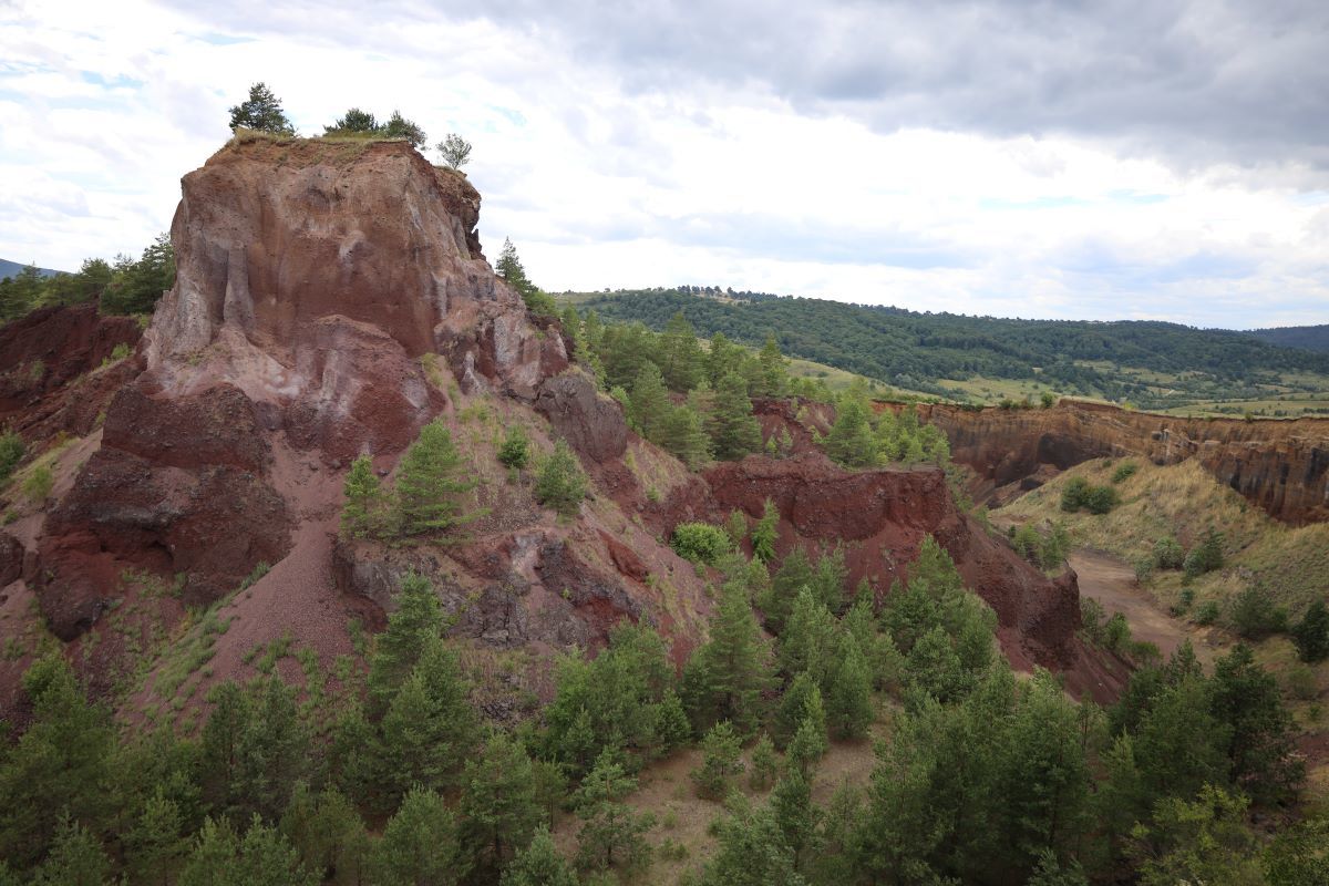
Vulcanul de pe Dealul Hegheș s-a format în urmă cu aproximativ 1,2 milioane de ani, ca urmare a unei erupții explozive. În timpul erupției, bucăți de lavă și așa-numitele bombe vulcanice au fost expulzate din conul vulcanului și s-au așezat în jurul craterului. Culoarea roșiatică a rocilor este cauzată de conținutul ridicat de fier și de oxidarea la temperaturi ridicate. Adâncitura vizibilă în crater este rezultatul exploatării zgurii.

Întrebare: În ce an a fost închisă întreaga zonă a vulcanului din cauza filmărilor din seria de filme Django? (produs de Canal+ și Sky, cu Matthias Schoenaerts în rolul principal). Suma cifrelor anului este echivalentul literei „a” din coordonatele geocache-ului.

STAȚIA 2 (N 46° 1.595 E 25° 25.485) - Coloanele de Bazalt

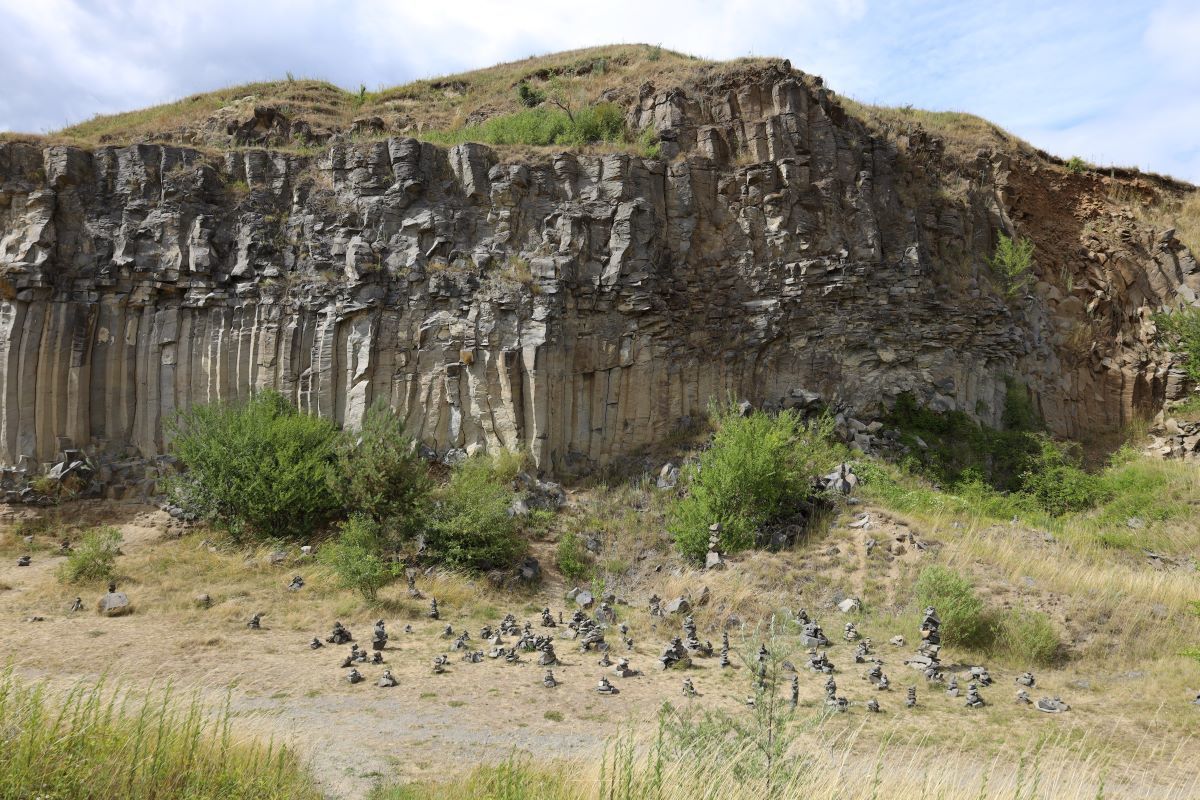
Un geotop este o unitate teritorială limitată spațial, cu o valoare naturală instructivă, un obiect geologic neînsuflețit, de interes din punct de vedere geologic, geomorfologic sau geoistoric. Geotopul din fața noastră păstrează memoria unei gropi de lavă sau a unui flux de lavă adânc de acum aproximativ 1,2 milioane de ani. Structura columnară a fost formată prin răcirea treptată a lavei. Puteți citi detalii interesante despre formarea Coloanelor de Bazalt pe panoul informativ.

Întrebare: În ce an au fost declarate monument al naturii Coloanele de Bazalt din Racoșul de Jos? A treia cifră a anului corespunde literei „b” din coordonatele geocache-ului.

STAȚIA 3 (N 46° 1.843 E 25° 25.524) - Lacul de Smarald (Geositul Brazi)

Lacul de Smarald din fața noastră este un lac destul de tânăr, unde la începutul anilor 2000 funcționa încă cariera de bazalt. Cu toate acestea, izvoarele, apa de ploaie și topirea zăpezii au umplut repede căldarea de bazalt și s-a creat lacul, care poate fi văzut și astăzi, și al cărui nivel al apei încă crește cu câțiva centimetri în fiecare an. În pozele de pe panoul informativ din fața ta poți observa creșterea nivelului apei de la începutul exploatării miniere până în prezent. Dacă ești curios să afli de ce apa din lac are culoare verzuie, de „smarald”, citește cu atenție descrierea de pe panou.

Întrebare: Câți ani au trecut între cea mai veche și cea mai nouă fotografie afișată pe panoul informativ? Numărul rezultat din două cifre ia locul literelor „cd” în coordonatele geocache-ului.


Ez a geoláda a ClimateQuest játék része. A játék elvezet téged Románia különböző vizes élőhelyeire, bemutatva a klímaváltozás és az emberi tevékenység ott érezhető hatásait.

Az Alsórákosi Geológiai Komplexum országos jelentőségű védett terület, a Homoród-dombság Natura 2000 terület része. A Komplexumot a több mint egymillió évvel ezelőtt lezajlott vulkáni tevékenység nyomai tették ismertté. A XX. században aktív kőbányászat folyt a területen, amely nagymértékben hozzájárult a táj jelenlegi arculatának kialakulásához.

Ez a multi-cache a Geológiai Komplexum három legfontosabb látványosságához kalauzol el. 

A ládát a N 46° c.dbb E 25° 25.ab1 koordinátán találod. A koordinátából hiányzó, betűkkel helyettesített számjegyeket az állomásokon feltett  kérdések megválaszolásával találod meg.

1. ÁLLOMÁS (N 46° 1.684 E 25° 25.087) -  A Hegyes-domb kialudt vulkánja

A Hegyes-domb vulkánja körülbelül 1,2 millió évvel ezelőtt, egy robbanásos kitörés következtében alakult ki. A kitörés során lávadarabok és ún. vulkáni bombák repültek ki a kürtőből, amelyek a kráter körül rakódtak le. A kőzetek vöröses színét a magas vastartalom, magas hőmérsékleten történt oxidációja okozza. A kráterben látható üreg a salakbányászat eredménye. 

Kérdés: Melyik évben volt lezárva a vulkán teljes területe a Django filmsorozat forgatása miatt? (Canal+ és Sky gondozásában, Matthias Schoenaerts főszereplésével). A évszám számjegyeinek összege a láda koordinátájában az “a” betű megfelelője.

2. ÁLLOMÁS (N 46° 1.595 E 25° 25.485) - A bazaltoszlopok

A geotóp egy földtani, felszínalaktani (geomorfológiai) vagy földtörténeti szempontból érdekes, tanulságos élettelen természeti érték, földtani objektum. Az előttünk álló geotóp egy megközelítőleg 1,2 millió évvel ezelőtti lávató vagy mély lávafolyás emlékét őrzi. Az oszlopos szerkezet a láva fokozatos lehűlésével alakult ki. A bazaltoszlopok keletkezéséről az információs táblán találsz érdekes részleteket.

Kérdés: Mikor nyilvánították természeti emléknek az Alsórákosi Bazaltoszlopokat? Az évszám harmadik számjegye a láda koordinátájában a “b” betű megfelelője.

3. ÁLLOMÁS (N 46° 1.843 E 25° 25.524) - Smaragd-tó (A Fenyős Geotóp)

Az elénk táruló Smaragd-tó egy meglehetősen fiatal tó, amely helyén a 2000-es évek elején még bazaltot bányásztak. Az itt található források, az esővíz és a hóolvadék azonban hamar feltöltötte a mélyedést, és létrejött a ma is látható tó, amelynek még most is évente több centiméterrel emelkedik a vízszintje. A előtted álló információs tábla képein megfigyelheted a víz szintjének növekedését a bányászat kezdetétől napjainkig. Ha érdekel, hogy mi okozza a tó zöldes, “smaragd” színét, olvasd el figyelmesen a táblán található leírást.

Kérdés: Hány év telt el az információs táblán feltüntetett legrégebbi és legújabb fénykép készítése között? A kapott kétjegyű szám a láda koordinátájában a “cd” betűk helyét foglalja el.


This geocache is part of the ClimateQuest game, which will guide you around some interesting wetlands in Romania and show you the effects of climate change, as well as the effects of human intervention on these habitats.

The Racoșul de Jos Geological Complex is a protected area of national importance, part of the Dealurile Homoroadelor Natura 2000 Site. The complex became famous due to the traces of volcanic activity that took place more than a million years ago. In the 20th century, the quarry was actively exploited in the area, which greatly contributed to the development of the current image of the landscape.

This multi-cache guides you to the three most important attractions of the Geological Complex.

The geocache is located at the coordinates N 46° c.dbb E 25° 25.ab1. The numbers that are missing from the coordinate and have been replaced by letters can be found by answering the questions in the three stations.

STATION 1 (N 46° 1.684 E 25° 25.087) - The extinct volcano on Hegheș Hill

The volcano on Hegheș Hill was formed approximately 1,2 million years ago, as a result of an explosive eruption. During the eruption, pieces of lava and so-called volcanic bombs were ejected from the cone of the volcano and settled around the crater. The reddish color of the rocks is caused by high iron content and oxidation at high temperatures. The visible hole in the crater is the result of slag mining.

Question: In what year was the entire volcano area closed due to the filming of the Django film series? (produced by Canal+ and Sky, starring Matthias Schoenaerts). The sum of the year's digits is the equivalent of the letter "a" in the geocache coordinates.

STATION 2 (N 46° 1.595 E 25° 25.485) – The Basalt Columns

A geotope is a spatially limited territorial unit of instructive natural value, an inanimate geological object of geological, geomorphological or geohistorical interest. The geotope in front of us preserves the memory of a lava pit or deep lava flow from about 1.2 million years ago. The columnar structure was formed by the gradual cooling of the lava. You can read interesting details about the formation of the basalt columns on the information board.

Question: In what year were the Basalt Columns from Racoșul de Jos declared a natural monument? The third digit of the year corresponds to the letter "b" in the geocache coordinates.

STATION 3 (N 46° 1.843 E 25° 25.524) - Smarald Lake (Brazi Geotope)

The Smarald Lake in front of us is a fairly young lake, where the basalt quarry was still operating in the early 2000s. However, springs, rainwater and snowmelt quickly filled the basalt caldera and created the lake, which can still be seen today, its water level still rising by a few centimeters each year. In the pictures on the information panel in front of you, you can see the increase in the water level from the beginning of the mining operation until now. If you are curious to know why the water in the lake has a greenish, "emerald" color, read carefully the description on the sign.

Question: How many years have passed between the oldest and the newest photo displayed on the information board? The resulting two-digit number takes the place of the letters "cd" in the geocache coordinates.

Additional Hints (Decrypt)

Oveqobk

Decryption Key

A|B|C|D|E|F|G|H|I|J|K|L|M
-------------------------
N|O|P|Q|R|S|T|U|V|W|X|Y|Z

(letter above equals below, and vice versa)