Poço de Maré da Baía da Aguada
a·gua·da (água + -ada) nome feminino
1. Lugar onde os navios se abastecem de água potável.
2. Abastecimento dessa água.
"aguada", in Dicionário Priberam da Língua Portuguesa

Temos por garantido o fornecimento de água potável de boa qualidade à distancia de uma torneira, mas nem sempre foi assim.
Hoje, como no passado, a colonização humana de um sítio só é possível com a existência de água. A água foi elemento crucial na colonização dos Açores, e as populações fixaram-se inicialmente nos locais onde a água era abundante. Rápidamente se procuraram meios que permitissem o estabelecimento de populações e atividades humanas nos locais onde a água não estava inicialmente disponível, entre essas tecnologias estava o poço de maré.
Poço de maré é a designação dada aos poços escavados ao longo da orla costeira visando captar as águas subterrâneas na zona de interação entre a massa de água doce e as águas do mar. A designação resulta do nível da água nestes poços, e também a sua salinidade, variarem com a maré. Este tipo de poço é muito comum em regiões insulares vulcânicas, onde a permeabilidade dos materiais geológicos é elevada e existe um aquífero basal em contacto direto com a água do mar.

A profundidade destes poços é tal que atingem o nível médio do mar, permitindo captar a água doce imediatamente antes da zona de descarga submarina de água subterrânea que está associada ao aquífero basal. Poços demasiado profundos correm risco de salinização, enquanto poços de profundidade insuficiente tendem a ficar secos nos períodos de maré baixa.
Podem ser encontrados na faixa costeira das ilhas dos Açores, em particular na ilha do Pico onde foram insubstituíveis no acesso à água, dada a escassez de fontes, nascentes, ou ribeiras.
Por norma, de carácter comunitário, para além de fornecerem água para fins domésticos, os poços de maré eram imprescindíveis para o fornecimento de todas as atividades produtivas dependentes de água, incluído o abastecimento das embarcações que atravessavam o Atlântico. Nestas ilhas a água chegou a ser transportada em carros de bois, diariamente, em pipas para as populações mais distantes.
A agua extraída do poço de maré não tem a mesma qualidade da água proveniente de nascente ou fonte, tendo geralmente um conteúdo de salinidade percetível quando consumida (água salobra), mas mesmo assim potável.
Muito embora os poços de maré tenham sido utilizados ainda durante o séc XX, na atualidade a água para consumo público é captada em nascentes, furos artesianos ou lagoas, e a sua qualidade é rigorosamente controlada, e os resultados dos controlos divulgados ao público.
Hoje, os poços de maré dos Açores são artefactos históricos que documentam os esforços das populações para sobreviver e prosperar num meio hostil.
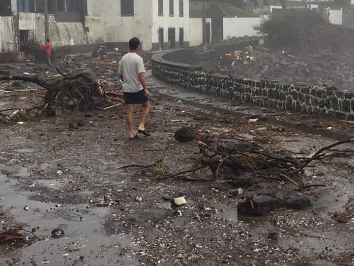
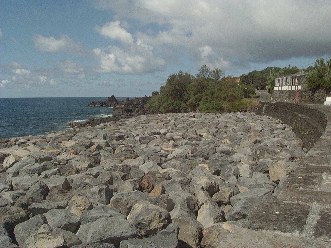
A 2 de outubro de 2019 a zona da Baía da Aguada foi fortemente atingida pelo furacão Lorenzo, foram posteriormente efetuadas obras de recuperação e a construção de um quebra mar junto ao paredão conforme se pode ver atualmente.
Vista Baía da Aguada.
No GZ poderá encontrar o poço de maré com a inscrição da data 1859, presumivelmente da sua construção, e as pias comunitárias usadas para lavar a roupa.
A cache contem apenas o logbook, tragam material de escrita.
Aguada Bay Tidal Well
a·gua·da (água + -ada) feminine noun
1. Place where ships are supplied with drinking water.
2. Supply of this water.
"aguada", in Priberam Dictionary of the Portuguese Language
We take for granted the supply of good quality drinking water at the distance of a tap, but this has not always been the case.
Today, as in the past, human colonization of a site is only possible with the existence of water. Water was a crucial element in the colonization of the Azores, and the populations initially settled in places where water was abundant. Means were sought to allow the establishment of populations and human activities in places where water was not initially available, among these technologies was the tidal well.
Tidal well is the designation given to wells dug along the coastline in order to capture groundwater in the zone of interaction between the freshwater body and the seawater. The designation results from the water level in these wells, and also their salinity, varying with the tide. This type of well is very common in volcanic island regions, where the permeability of geological materials is high and there is a basal aquifer in direct contact with seawater.
The depth of these wells is such that they reach the mean sea level, allowing the capture of fresh water immediately before the subsea groundwater discharge zone that is associated with the basal aquifer. Wells that are too deep are at risk of salinization, while wells that are too shallow tend to be dry at low tide.
They can be found on the coast of the Azores islands, particularly on the island of Pico, where they were irreplaceable in terms of access to water, given the scarcity of springs or streams.
As a rule, of a community nature, in addition to providing water for domestic purposes, tidal wells were essential for the supply of all productive activities dependent on water, including the supply of vessels crossing the Atlantic. In these islands, water was transported in ox carts, daily, in kites to the most distant populations.
The water extracted from the tidal well does not have the same quality as the water coming from a spring or stream, generally having a noticeable salinity content when consumed (brackish water), but still drinkable.
Although tidal wells were still used during the 20th century, water for public consumption is currently collected from springs, artesian wells or ponds, and its quality is strictly controlled, and the results of the controls are made public.
Today, the tidal wells of the Azores are historical artifacts that document the efforts of populations to thrive in a hostile environment.
On October 2, 2019, the Aguada Bay area was heavily hit by hurricane Lorenzo, and recovery works were later carried out and a breakwater was built next to the seawall, as can be seen today.
In the GZ you can find the tidal well with the inscription of the date 1859, presumably of its construction, and the communal sinks used for washing clothes.
The cache contains only the logbook, bring writing material.