
La Earthcache / The Earthcache
► Contexte géologique local
La bord de la Vallée du Layon au niveau de Pont Barré présente des particularités géologiques et topographiques, fruit d'une histoire géologique caractérisée par la faille du Layon.

► Faille et Vallée du Layon
La région du Layon est marquée par un accident géologique majeur, la faille du Layon qui s’étire sur 120 km entre Blain et Doué-la-Fontaine.
Il induit des effets de parois et un relief abrupt qui définit le coteau rive droite de la rivière.
Cette faille juxtapose deux domaines, les schistes briovériens (domaine sud) et les formations volcano-sédimentaires datant du Silurien de la série de Saint-Georges (domaine nord).
Cet accident du Layon est en outre jalonné d'un bassin sédimentaire du Carbonifère installé dans le cisaillement entre les deux domaines, le Sillon houiller de la Basse-Loire.
Ce sillon s'est mis en place il y a 320 Ma (étape 3) avant de basculer à la verticale lors de la mise en place de la faille (étape 4) entrainant sa mise au contact avec les deux domaines nord et sud.

► Les formations au contact à Pont-Barré
Le coteau de Pont-Barré met à jour un des deux contacts.
~ Une formation volcanique, la Spilite du domaine nord
Ces formations volcaniques de l'Unité de Saint-Georges se sont mises en place il y a 400 Ma.
La spilite est une roche cristalline à structure microlitique (grains invisibles à l'oeil nu).
De couleur sombre (verdâtre à noire), elle prend une coloration brunâtre quand elle est altérée.

~ Une formation sédimentaire, les grès et conglomérats du Sillon houiller
Ces dépôts sédimentaires sont issus de l'érosion fluviale des massifs environnants.
Selon la vitesse du courant, différents sédiments se sont déposés selon leur taille (granoclassement) et leur nature géologique.
- Des sables principalement quartzeux, d'une taille inférieure à 2 milllimètres.
- Des graviers et des galets (> 2 millimètres) principalement de quartz blanc ou phtanite noire.
Ces sédiments se sont consolidés en deux types de roches selon la taille des grains :
- Les sables consolidés sont devenus du grès
- Les graviers et galets cimentés par une matrice fine ont formé un conglomérat (poudingue).

► Local geological context
The edge of the Layon Valley at Pont Barré has geological and topographical particularities, the result of a geological history characterized by the Layon fault.
► Layon Fault and Valley
The Layon region is marked by a major geological accident, the Layon Fault, which stretches over 120 km between Blain and Doué-la-Fontaine.
It induces wall effects and an abrupt relief that defines the right bank hillside of the river.
This fault juxtaposes two basement domains, the Brioverian shales (southern domain) and the volcano-sedimentary formations of the Silurian Saint-Georges series (northern domain).
This Layon accident is also marked by a Carboniferous sedimentary basin installed in the shear between the two areas, the Sillon houiller de la Basse-Loire.
This furrow was set up 320 Ma ago (stage 3) before tilting vertically during the setting up of the fault (stage 4) bringing it into contact with the two northern and southern domains.
► Contact formations in Pont-Barré
The hillside of Pont-Barré updates one of the two contacts.
~ A volcanic formation, the North Domain Spilite
These volcanic formations of the Saint-Georges Unit were set up 400 Ma ago.
Spilite is a crystalline rock with a microlitic structure (grains invisible to the naked eye).
Dark in color (greenish to black), it takes on a brownish color when it is altered.
~ A sedimentary formation, the sandstones and conglomerates of the Coal Furrow
These sedimentary deposits come from the fluvial erosion of the surrounding massifs.
Depending on the speed of the current, different sediments were deposited according to their size (grading) and their geological nature.
- Mainly quartz sands, less than 2 millimeters in size.
- Gravels and pebbles (> 2 mm) mainly of white quartz or black phtanite.
These sediments consolidated into two types of rocks depending on the grain size:
- Consolidated sands have become sandstone
- The gravels and pebbles cemented by a fine matrix have formed a conglomerate (puddingstone).
► Sources bibliographiques / Bibliographical sources
Les Questions / The Questions
Questions pour valider :"La Vallée du Layon à Pont Barré"
Questions to validate: "The Layon Valley at Pont Barré"
Point 1 : N 47° 19.004 W 000° 37.073'
Après avoir attaqué l'ascension du côteau depuis le début du sentier (point de passage TH1), vous pouvez voir un affleurement au niveau du talus de droite (photo WP1).
After attacking the ascent of the hill from the start of the trail (TH1 crossing point), you can see an outcrop at the level of the right embankment (photo WP1).
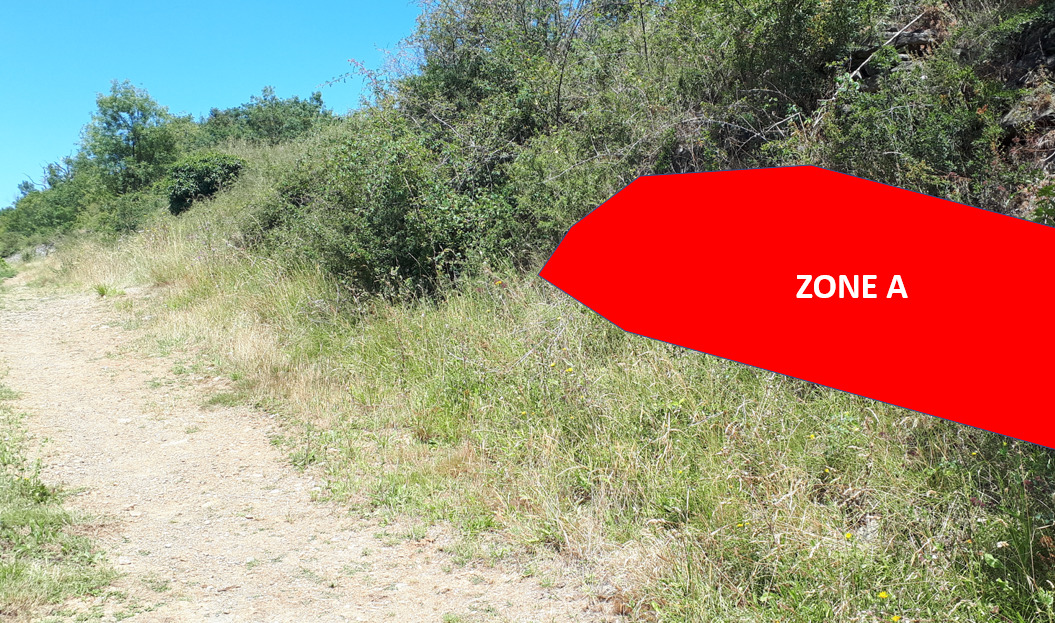
- Question 1 : Décrivez l'affleurement sous la zone rouge A (couleur, taille des éléments, roche cristalline ou cimentée). Déduisez-en sa nature.
- Question 1: Describe the outcrop under red zone A (color, size of features, crystalline or cemented rock). Deduce its nature.
Point 2 : N 47° 19.017 W 000° 37.045'
Poursuivez votre chemin jusqu'à longer une barrière en bois. Au bout de cette barrière le sentier fait un virage à 90° devant un éperon rocheux (photo WP2).
Continue on your way until you reach a wooden barrier. At the end of this barrier, the path makes a 90° turn in front of a rocky outcrop (photo WP2).

- Question 2 : Décrivez le piton rocheux sous la zone bleue B (couleur, taille des éléments, roche cristalline ou cimentée). Déduisez-en sa nature.
- Question 2: Describe the rocky peak under the blue zone B (color, size of the elements, crystalline or cemented rock). Deduce its nature.
Point 3 : N 47° 19.033 W 000° 37.073'
Vous voici à un point de vue sur la Vallée du Layon.
Here you are at a viewpoint over the Layon Valley.
- Question 3 : Prenez l'altitude au WP3. Sachant que l'altitude au départ du sentier était de 30 mètres, expliquez la raison de cette variation d'altitude. Vous pouvez vous aider du descriptif.
- Question 3: Take the altitude at WP3. Knowing that the altitude at the start of the trail was 30 meters, explain the reason for this variation in altitude. You can help yourself from the description.
- Question 4 : Par rapport à la faille du Layon, êtes-vous présent sur les roches du domaine géologique nord ou celui du sud ?
- Question 4: Compared to the Layon fault, are you present on the rocks of the northern or southern geological domain?
- Question 0 : Prenez une photo de vous ou d'un élément vous appartenant avec avec la Vallée du Layon en arrière plan.
Cette photo devra au choix nous être transmise avec les réponses ou être ajoutée à votre log.
-Question 0 : Take a picture of yourself or something belonging to you with the Layon Valley in the background.
This photo must either be sent to us with the answers or added to your log.
Vous pouvez vous loguer sans attendre notre confirmation,
mais vous devez nous envoyer les réponses en même temps soit par mail via notre profil (
fafahakkai), soit via la messagerie geocaching.com (Message Center).
S'il y a des problèmes avec vos réponses nous vous en ferons part.
Les logs enregistrés sans réponse seront supprimés.You can log this cache without waiting for our confirmation, but you must send us the answers at the same time, by e-mail via our profile (fafahakkai) or by the system of Message Center of geocaching.com.
If there is a problem with your answers we will notify you. The logs recorded without answers will be deleted.
Rappel concernant les « Earthcaches »: Il n'y a pas de conteneur à rechercher ni de logbook à renseigner. Il suffit de se rendre sur les lieux, de répondre aux questions ci-dessus et de nous renvoyer les réponses.
Reminder concerning "Earthcaches": there is neither a container to look for nor a logbook to sign. One need only go to the location, answer to the differents questions and send us the answers.