ESTAÇÃO RAEGE
(Santa Maria)
PORTUGUÊS


ESTAÇÃO RAEGE
Sê bem-vind@ à Estação RAEGE de Santa Maria! Deves estar a perguntar-te o que é est lugar, o que fazemos e como o fazemos. Vamos explicar-te tudo!
Sê bem-vind@ à Estação RAEGE de Santa Maria! Deves estar a perguntar-te o que é este lugar, o que fazemos e como o fazemos. Vamos explicar-te tudo!
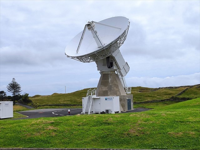
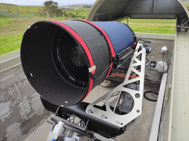
Para isso, utilizamos várias técnicas, como o VLBI (Very Long Baseline Interferometry) com a antena que, provavelmente, estás a ver agora e que te está a despertar toda esta curiosidade. Essa antena é um radiotelescópio que observa fontes, em simultâneo com outras antenas no espaço profundo, os quasares (buracos negros supermassivos!!!) que são usados como referências. Mas também usamos a técnica GNSS (Global Navigation Satellite System) usando recetores de alta precisão que captam o sinal dos satélites de navegação de várias constelações que andam por aí em cima das nossas cabeças (GPS, Galileo, etc.). Para além destes, a estação também possui um gravímetro, para medir as alterações da gravidade neste local.

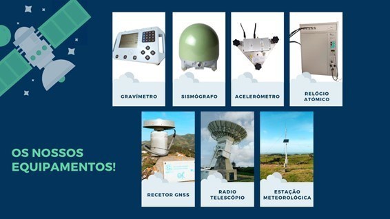 sismógrafo e um acelerómetro, para o registo de eventos sísmicos.
Campo Gravítico – sabias que a força da gravidade não é sentida da mesma forma em todos os pontos do planeta?
Esta é uma Estação Geodésica Espacial, ou seja, aqui recolhemos dados importantes para o estudo do planeta Terra recorrendo ao espaço e a tecnologia espacial.
Com base nestes dados conseguimos perceber a Forma da Terra e como ela se vai deformando ao longo do tempo, a Orientação Espacial do planeta, como a posição
dos polos e como o eixo de rotação da Terra se vai alterando...
Estes dados também são muito importantes para o desenvolvimento de estudos sobre a evolução e movimentos do nosso planeta, alterações climáticas e muito mais!
Queres saber mais sobre o impacto de estações como esta na nossa vida?
Segue-nos nas Redes Sociais (@raege.az) e fica a par de tudo!
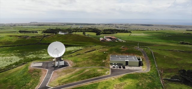
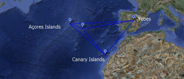
Esta estação integra a Rede RAEGE – Rede de Estações Geodinâmicas e Espaciais, que surgiu de um memorando entendimento entre o Governo dos Açores e o Governo de Espanha, para a implementação de quatro estações semelhantes a esta, estrategicamente posicionadas em três placas tectónicas diferentes: duas nos Açores (Santa Maria e Flores) e duas em Espanha (Yebes e Gran Canária).
Fica a saber mais sobre este projeto em www.raege-az.pt!
A CAIXA
A caixa tem um formato convencional.
Tenha em atenção os muggles.
Deixe, tudo como encontrou.
ESTAÇÃO RAEGE
(Santa Maria)

ENGLISH

Spacial station RAEGE
Welcome to RAEGE Station of Santa Maria! You must be wondering what this place is, what we do, and how we do it. Well, we will explain everything to you!
This is a Space Geodetic Station, in other words, we collect important data for the study of planet Earth using space technology. Based on this data, we are able to understand the Earth’s Shape and Size and how it is deformed over time, the Earth’s Spatial Orientation, such as how the position of the poles and how the axis of rotation of the Earth is changing, and the Gravitic Field – did you know that the gravity force is not felt in the same way at all points of the planet?
But to be able to study all this, we use several techniques such as VLBI (Very Long Baseline Interferometry) with the antenna that you are probably seeing now and that is arousing all this curiosity. This antenna is a Radio telescope that observes deep space sources, together with other antennas, the Quasars (supermassive black holes!!!) that are used as references. But we also use the GNSS technique (Global Navigation Satellite System) using high-precision receivers that capture the signal from the navigation satellites that are out there, above our heads (i.e., GPS, Galileo, etc.). In addition to these, the station also has a gravimeter, that measures changes in gravity at this location, a seismograph, and an accelerometer for recording seismic events.
These data are also very important to study the evolution and dynamics of our planet, climate change, and much more! Do you want to know more about the impact of stations like this on our lives? Follow us on Social Media (@raege.az) and stay updated about everything!
This station is part of the RAEGE Network – Rede Atlântica de Estações Geodinâmicas e Espaciais (Atlantic Network of Geodynamic and Space Stations), which was established from a memorandum of understanding between the Azores Government and the Spain Government, for the implementation of four stations like this one, strategically positioned on three different tectonic plates: two in the Azores islands (Santa Maria and Flores) and two in Spain (Yebes and Gran Canaria).
Find out more about this project at www.raege-az.pt!
THE CACHE
The box has a conventional format.
Watch out for muggles.
Leave it all as you found it.