PR4 MCQ - Trilho dos Moinhos 
 A caminhada percorre a vila serrana de Monchique e a paisagem envolvente a norte, dando a conhecer árvores classificadas, os carvalhais típicos da serra e o Barranco dos Pisões. Todo o percurso é particularmente interessante para observar a fauna associada a zonas arborizadas e a avifauna em particular, com destaque para espécies como o pica-pau-verde, a carriça, a trepadeira-comum, o gaio, ou o chapim-azul, entre muitas outras.
À saída de Monchique encontra-se o maior exemplar de araucária-de-Norfolk existente na vila, uma árvore classificada com 150 anos e 44 metros característicos de altura. As encostas envolventes cobrem-se de bosques de carvalhos que alternam com hortas e pomares onde se contemplam macieiras e imponentes cerejeiras e castanheiros.
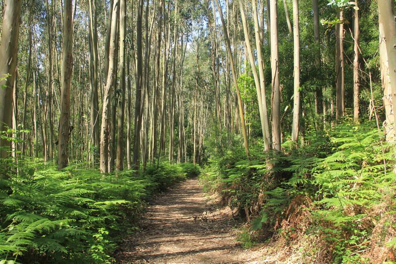
Após a travessia de uma mata de eucalipto, os bosques de sobro e medronho adensam-se, acompanhados por urzais e feteiras, e o caminho desce até ao Barranco dos Pisões. Esta linha de água é o principal afluente da Ribeira de Seixe que nasce em Monchique, delimita parte da fronteira entre o Algarve e o Alentejo, e desagua em Odeceixe.
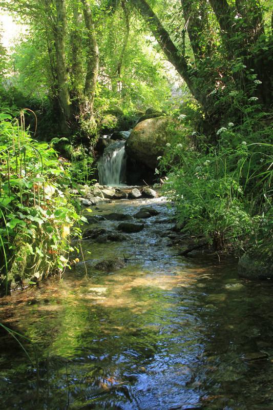
No barranco, o som da água corrente é presença constante e a vegetação torna-se luxuriante. A galeria ribeirinha é frondosa, formando uma cortina densa de amieiros, freixos e salgueiros. Um soberbo plátano guarda a entrada da área de lazer; esta árvore classificada tem 150 anos e 41 metros de altura. Encontra-se aqui o Moinho do Poucochinho; inicialmente construído para tratar lã utilizando o pisão (engenho com martelo de madeira que a água levanta e faz cair sobre o tecido), foi posteriormente convertido para moagem de cereais.
Percorrem-se manchas de eucaliptal, bosques de sobro e os típicos socalcos serranos, até que se alcança o Barranco do Carvalho. Aqui, entre amieiros, salgueiros e castanheiros, encontra-se um bosque classificado de azevinho, planta protegida e raríssima no sul do país.
 O Convento de Nossa Senhora do Desterro, fundado em 1631, ergue-se sobre Monchique, envolto num bosque sombrio de sobro. Os frades franciscanos que aqui viveram influenciaram o imaginário da população, devido ao estado de degradação do edifício, não se recomenda a visitação ao interior das ruínas, por questões de segurança.. Neste local, a vista alonga-se sobre a vila e cerros envolventes.
Concelho: Monchique
Localização: Monchique
Tipo: pedestre
Percurso Circular: sim
Distância: 9,4 km
Duração média: 3 h
Subida acumulada: 485 metros D+
Tipo de caminho: caminhos de terra e estrada
Alerta: Está prestes a transferir um ficheiro que contém mais detalhes necessários para encontrar este geocache. Como proprietário da geocache, declaro que este arquivo é seguro para download, embora não tenha sido verificado pela Groundspeak ou pelo revisor quanto a possíveis conteúdos maliciosos.
Transfira este ficheiro por sua conta e risco: Descarregar GPX
The trail runs through the mountain village of Monchique and the surrounding landscape to the north, allowing you to see protected trees, oak groves typical of the mountains, and the Barranco dos Pisões. The entire trail is particularly interesting for observing the wildlife of the wooded areas and the birdlife in particular, with special emphasis on species such as the European green woodpecker, the Eurasian wren, the short-toed treecreeper, the Eurasian jay, or the Eurasian blue tit, among many others.
Right outside of Monchique stands the largest specimen of Norfolk pine in the village, a protected tree 150 years old and 44m tall. The surrounding slopes are covered in oak groves alternating with vegetable gardens and orchards where you can see apple trees and imposing cherry and chestnut trees.
After crossing a forest of eucalyptus, the groves of cork oak and strawberry trees thicken, accompanied by beds of heath and ferns, and the road slopes down to Barranco dos Pisões. This stream is the main tributary of the Ribeira de Seixe, a river born in Monchique which demarcates part of the border between the Algarve and the Alentejo, and flows into Odeceixe.
Along the ravine, the sound of flowing water is a constant presence, and the vegetation becomes luxuriant. The riparian gallery is full and exuberant, forming a dense curtain of alders, ashes and willows. A superb sycamore guards the entrance to the leisure area; this protected tree is 150 years old and 41m tall. Here you’ll find the Poucochinho Mill; initially built to treat wool using the pisão (a water engine with a wooden hammer that the water raises and drops on cloth), it was later converted to grain milling.
You will cross copses of eucalyptus, cork oak groves and the typical mountainous terraces until you reach the Barranco do Carvalho. Here, among alders, willows and chestnut trees, there is a protected forest of holly, an endangered and very rare plant in southern Portugal.
The Convent of Our Lady of Desterro, founded in 1631, stands over Monchique, enveloped by a shaded oak forest. The Franciscan friars who lived here influenced the imagination of the population, due to the state of degradation of the building, it is not recommended to visit the interior of the ruins, for safety reasons.. In this spot, the view stretches over the village and surrounding hills.
Municipality: Monchique
Location: Monchique
Type: walking
Circular trail: yes
Distance: 9,4 km
Average duration: 3h
Cumulative elevation gain: 485 metres D+
Type of path: dirt paths and road
Alert: You are about to download a file that contains more details needed to find this geocache. As the owner of the geocache, I declare that this file is safe to download, although it has not been checked by Groundspeak or the reviewer for possible malicious content.
Download this file at your own risk: GPX Track donwload