
Cette cache n'est pas accessible en cas de crue du ruisseau
This cache is not accessible in case of flooding of the stream

click on the flag to reach the translation
Crédits: Fredagnes / Vulka
Une Earthcache
Il ne s’agit pas d’une cache physique. Pour loguer cette cache, vous devez dans un premier temps prendre connaissance de sa description éducative en matière de géologie, puis d’observer le site sur lequel vous êtes, et enfin de répondre aux questions qui vous seront posées.
Vous pourrez alors loguer en "Found it" sans attendre mais vous devez me faire parvenir vos réponses en même temps en me contactant soit par mail dans mon profil, soit via la messagerie geocaching.com (Message Center), et je vous contacterai en cas de problème. Les logs enregistrés sans réponses seront supprimés.

Un peu de géologie
Arénisation du granite
Le granite est une roche dure et résistante mais elle manque de souplesse. Avec les mouvements de l'écorce terrestre et au cours de son refroidissement, le granite fini par se fissurer. Les fractures qu'on appelle également diaclases facilitent l'altération en permettant à l'eau et aux racines des plantes de s'infiltrer plus rapidement au cœur de la roche.
L'eau agit de deux façons différentes :
- par hydratation : l'eau s'additionne à certains composés du granite qui finissent par gonfler puis par se désolidariser de la roche.
- par hydrolyse : l'eau solubilise certains éléments du granite
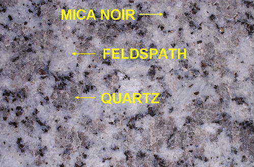
Les minéraux composant le granite réagissent différemment à l'altération :
- le mica noir, en présence d'eau, s'hydrolyse rapidement en hydroxyde de fer et en argile.
- le quartz est inaltérable
- les feldspaths s'hydrolysent et se transforment en argiles.

Un granite altéré est appelé un "granite pourri", mais l'altération se poursuit et le granite pourri va se transformer en sable grossier pour donner "l'arène granitique"
Sédimentation
Sédimentation : Ensemble des processus qui conduisent à la formation de sédiments. Modes divers :
- sédimentation marine, littorale ou côtière, océanique, bathyale, abyssale, … ;
- sédimentation lagunaire, dans des zones séparées de la mer par un cordon littoral ;
- sédimentation continentale, éolienne, fluviatile, deltaïque, lacustre, glaciaire, … .
Sédiment du latin sedimentum, dépôt, de sedere, être assis - séjourner (dont découle aussi sédentaire).
Des particules plus ou moins grosses, ou des matières précipitées qui ont, séparément, subi un certain transport (par le vent, l'eau, ...), peuvent se rassembler et constituer un ensemble appelé "sédiment". Leurs matériaux peuvent provenir de l'érosion de roches plus anciennes, de transports de divers matériaux meubles ou fluides, ou être les résultats d'activités organiques diverses. Selon son origine, le sédiment peut être marin, fluviatile, lacustre ou glaciaire. Après son dépôt, il peut subir une diagenèse et devenir une roche sédimentaire.
Bien qu'il soit usité pour faire allusion à un mode de formation, le mot "sédiment" désigne le dépôt récent, encore meuble, se trouvant encore sur son lieu de formation et souvent, encore gorgé d'eau. Lorsqu'il a été induré, qu'il a subi compactation et perte d'eau d'inbibition originelle, on parle de roche sédimentaire…
Alluvion du latin alluvio, débordement: Sédiment transporté et/ou déposé par les cours d'eau. Selon, l'intensité du courant et les régions drainées et traversées, la composition des alluvions va différer, galets, graviers, sables, et dans les zones inondables, argile et limons. Le transport-dépôt des alluvions correspond à une sorte de tri mécanique débouchant sur la concentration de substances utiles et débouche donc sur des possibilités d'exploitations artisanales ou industrielles de matières qui, généralement sont rares dans leurs roches mères. On aura des alluvions aurifères or, diamantifères, gemmifères (gemmes diverses), stannifères étain, etc.
Alors, si on résume, que faut-il pour qu'un cours d'eau "vive" ? Il faut avant tout un minimum de pente (sinon l'eau s'accumule et crée un lac...). D'où viennent les matériaux à transporter : ici essentiellement le granite. Ensuite, il faut un agent transporteur, ici c’est l'eau. Et enfin, il faut également que la vitesse d’écoulement soit suffisamment forte pour permettre l'érosion des berges et le transport des matériaux, pour que le ruisseau, puis la rivière, creuse son lit.
Granulométrie
La classification granulométrique est celle cmmunément utilisée pour les roches sédimentaires d'origine détritique. Elle est basée sur la taille éléments (ou clastes) et sur la consolidation ou non de ces derniers suivant le tableau suivant 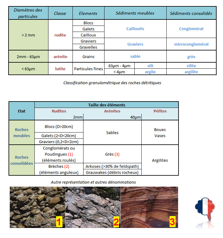

Questions
Question 0 - Prenez une photo de vous, ou de votre objet distinctif de géocacheur, ou de votre pseudo écrit sur une feuille de papier ou dans votre main... en aval du ruisseau (ne pas montrer les zones d'observation), et joignez-là à votre log ou à vos réponses
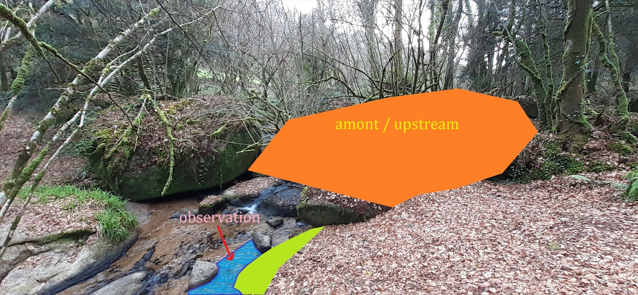
Point d'observation - Ne pas traverser le ruisseau, rejoignez ce point d'observation à partir du sentier en descendant à partir du waypoint dans le bois
Question 1 - Décrivez la zone en amont (en orange) du point d'observation
Question 2 - Plongez les mains dans le ruisseau et saisissez la matière qui est au fond. Décrivez ces "grains" (couleur,taille, homogénéité).
Question 3 - D'où proviennent ces grains, géologiquement parlant ?
Question 4 - Peut-on parler de sédiments ou d'alluvion (justifiez votre réponse) ?
Question 5 - A quelle classification granulométrique peuvent être associé ces grains (voir leçon) ?
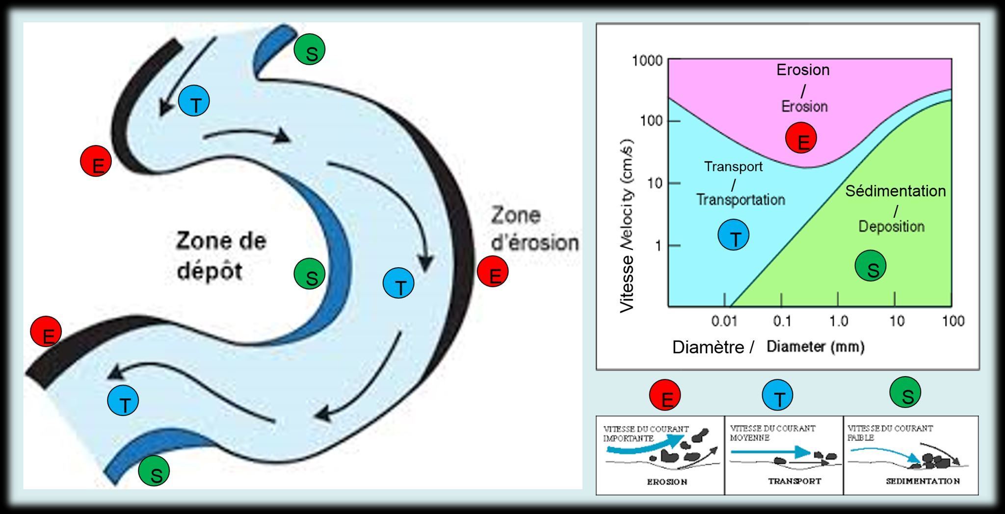
Question 6 - Sommes-nous dans une zone de sédimentation (S), de transport (T) ou d'érosion (E)
Question 7 - Evaluez la vitesse nécessaire du cours d'eau à ce niveau pour que ce processus se produise (voir leçon)

An Earthcache
It is not a physical cache. To log this cache, you must first learn about its educational description in geology, then observe the site on which you are, and finally answer the questions that will be asked.
You can then log in "Found it" without waiting but you must send me your answers at the same time by contacting me either by mail in my profile, or via the messaging geocaching.com (Message Center), and I will contact you in case of problem. Saved logs without answers will be deleted.
A little of geology
Granite arenization
Granite is a hard and resistant rock but it lacks flexibility. With the movements of the earth's crust and during its cooling, the granite eventually cracks. Fractures, also called diaclases, facilitate weathering by allowing water and plant roots to infiltrate more quickly into the heart of the rock.
Water works in two different ways:
- by hydration: the water is added to certain compounds of the granite which end up swelling and then separating from the rock.
- by hydrolysis: water solubilizes certain elements of the granite
The minerals that make up granite react differently to weathering:
- black mica, in the presence of water, hydrolyzes rapidly to iron hydroxide and clay.
- quartz is unalterable
- feldspars hydrolyze and turn into clays.
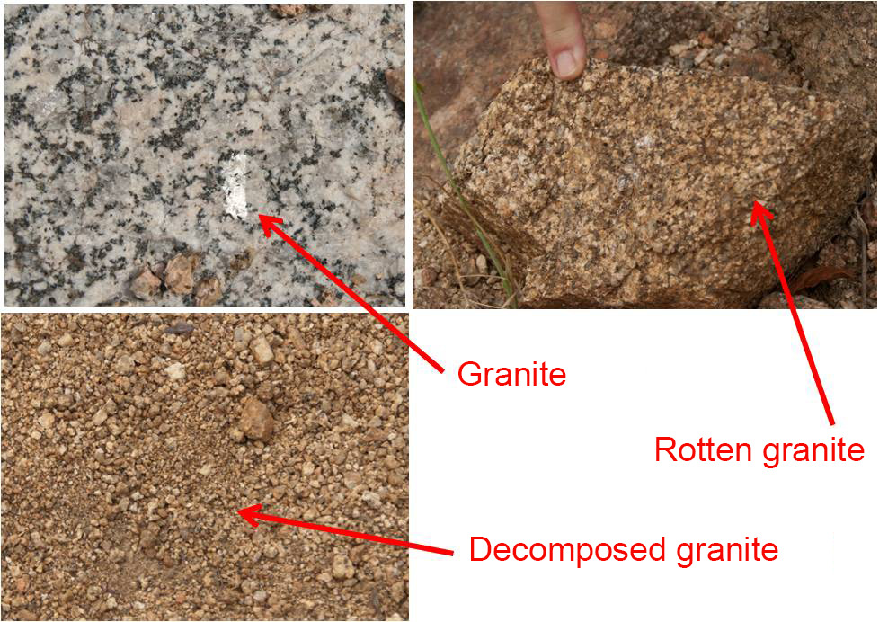
Weathered granite is called a "rotten granite", but weathering continues and the rotten granite will turn into coarse sand to give the "granite arena"
Sedimentation
Sedimentation : All the processes that lead to the formation of sediments. Various modes:
- marine, littoral or coastal, oceanic, bathyal, abyssal sedimentation,…;
- lagoon sedimentation, in areas separated from the sea by a coastal barrier;
- continental, wind, fluvial, deltaic, lacustrine, glacial sedimentation, etc.
Sediment from Latin sedimentum , deposit, from sedere , to sit - to stay (from which also derives sedentary).
More or less coarse particles, or precipitated materials which have separately undergone a certain transport (by wind, water, etc.), can come together and form a whole called "sediment". Their materials can come from the erosion of older rocks, the transport of various loose or fluid materials, or be the result of various organic activities. Depending on its origin, the sediment can be marine, fluvial, lacustrine or glacial. After its deposition, it can undergo diagenesis and become a sedimentary rock.
Although it is used to allude to a mode of formation, the word "sediment" designates the recent deposit, still loose, still being on its place of formation and often, still saturated with water. When it has been hardened, when it has undergone compacting and loss of original water of imbibition, we speak of sedimentary rock…
Alluvion from Latin alluvio , overflow: Sediment transported and / or deposited by watercourses. Depending on the intensity of the current and the regions drained and crossed, the composition of alluvium will differ, pebbles, gravel, sands, and in the floodplains, clay and silt. The transport-deposition of alluvium corresponds to a kind of mechanical sorting leading to the concentration of useful substances and therefore leads to the possibilities of artisanal or industrial exploitation of materials which are generally rare in their source rocks. We will have gold, diamondiferous, gemmiferous (various gems), tin tin-bearing alluviums, etc.
So, if we summarize, what does it take for a river to "live"? Above all, you need a minimum of slope (otherwise water accumulates and creates a lake ...). Where do the materials to transport come from: here mainly granite. Then you need a carrier agent , here it's water. And finally, the flow velocity must also be strong enough to allow the erosion of the banks and the transport of materials, so that the stream, then the river, digs its bed.
Granulometry
The particle size classification is that commonly used for sedimentary rocks of detrital origin. It is based on the size of the elements (or clasts) and on the consolidation or not of the latter according to the following table 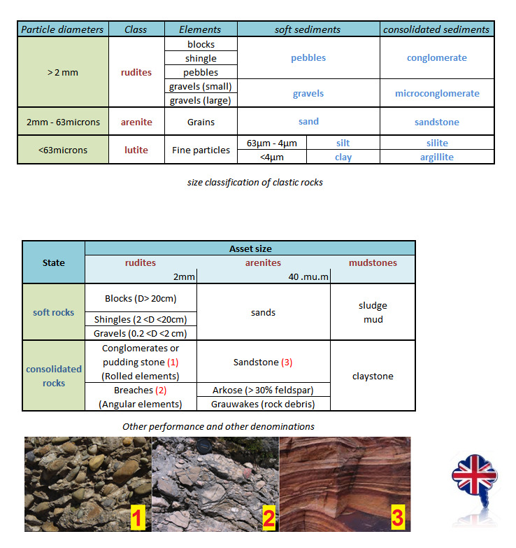
Questions
Question 0 - Take a picture of yourself, or your distinctive geocacher item, or your written nickname on a sheet of paper or in your hand...down stream (do not show viewing areas), and attach it to your log or answers
Observation point - Do not cross the stream, reach this observation point from the trail by descending from from the waypoint in the wood
Question 1 - Describe the area upstream (in orange) of the observation point
Question 2 - Dip your hands into the stream and grab the material at the bottom. Describe these "grains" (color, size, homogeneity).
Question 3 - Where did these grains come from, geologically speaking?
Question 4 - Can we talk about sediments or alluvium (justify your answer)?</ p>
Question 5 - What size classification can these grains be associated with (see lesson)?
Question 6 - Are we in a zone of sedimentation (S), of transport (T) or erosion (E)
Question 7 - Estimate the necessary stream velocity at this level for this process to occur (see lesson)