Au lieu-dit Miné Bibon, qui marque le point culminant de la route de Saint-Thurien à Guiscriff, le granite affleure en plusieurs endroits. En venant de Saint-Thurien, on aperçoit sur la gauche, une sorte de monolithe granitique dominant les pâturages environnants.
At a place called Miné Bibon, which marks the highest point of the road from Saint-Thurien to Guiscriff, granite outcrops in several places. Coming from Saint-Thurien, you can see on the left a sort of granite monolith dominating the surrounding pastures.
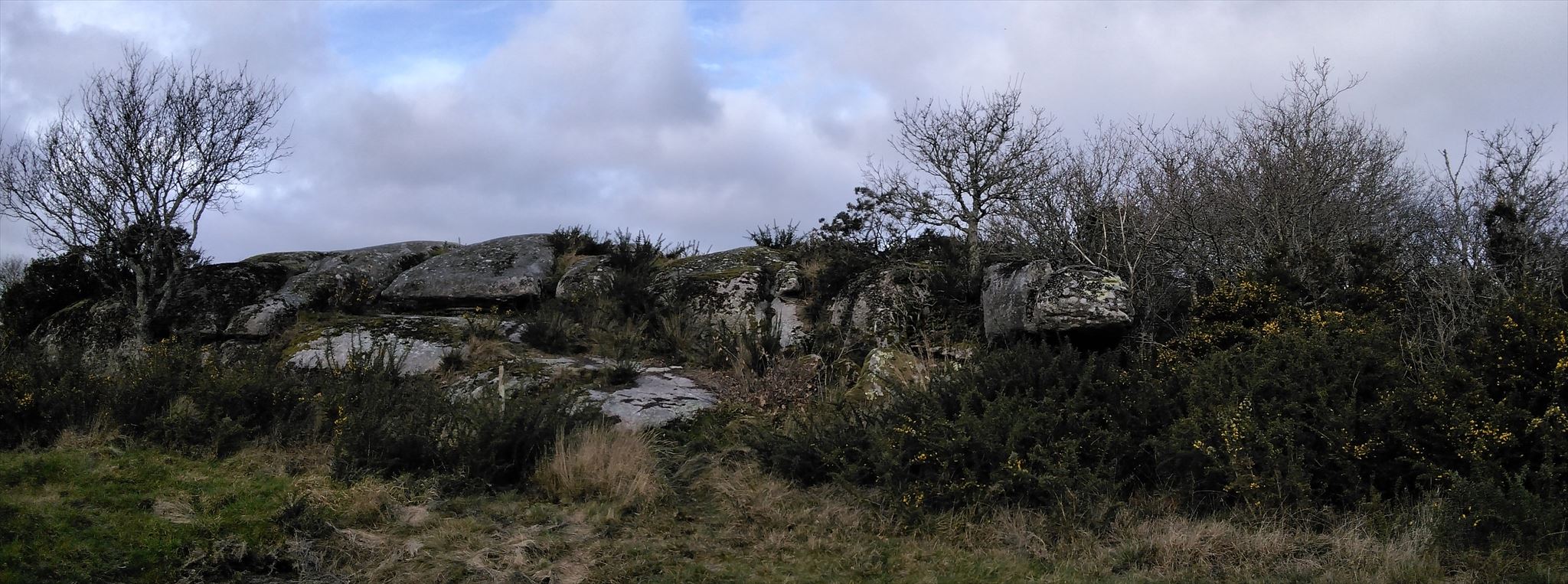
Contrairement à la plupart des sommets rocheux bretons qui prennent l'aspect d'aiguilles taillées dans les grès, le rocher de Miné Bibon (208 m d'altitude) se présente comme une éminence rocheuse tabulaire sur près de 400m2.
Unlike most Breton rocky peaks which take on the appearance of needles cut into the sandstone, the rock of Miné Bibon (208 m above sea level) looks like a tabular rocky eminence over nearly 400m2.
La géologie du secteur / geology of the area
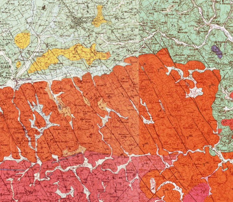
Le sous-sol guiscrivite est constitué de roches métamorphiques de faible degré et de roches granitiques correspondant aux couches de moyenne profondeur de la chaîne hercynienne, une ancienne chaîne de montagne aujourd'hui fortement érodée. Les terrains des deux tiers nord de Guiscriff sont ainsi des schistes et des micaschistes tandis que ceux du tiers sud sont des leucogranites (granites contenant des cristaux de mica blanc).
The Guiscrivite basement is made up of low-grade metamorphic rocks and granitic rocks corresponding to the medium-depth layers of the Hercynian range, an ancient mountain range that is now heavily eroded. The lands of the northern two-thirds of Guiscriff are thus schists and mica-schists while those of the southern third are leucogranites (granites containing crystals of white mica).
Ces leucogranites sont principalement du Granite de Cascadec qui apparaît en de nombreuses occurrences dans les anciennes carrières mais aussi en bordure des routes, entre Pont Ledan et la papeterie de Cascadec, près de Cremenet et Pont Meur ou encore au Sud de Stang Boutin, entre Saint-Alarin et Kerhoadic. On le découvre aussi en affleurements rasant sur les sommets et les versants des collines, notamment ici à Miné Bidon, mais aussi dans les secteurs de Raden, de Manoir Guéguen, de Rozcariou, de Livinot, de Kerhervé et Keranvel.
These leucogranites are mainly Cascadec Granite which appears in numerous occurrences in old quarries but also along the roads, between Pont Ledan and the Cascadec paper mill, near Cremenet and Pont Meur or even south of Stang Boutin, between Saint -Alarin and Kerhoadic. It is also found in low outcrops on the summits and slopes of the hills, especially here at Miné Bidon, but also in the sectors of Raden, Manoir Guéguen, Rozcariou, Livinot, Kerhervé and Keranvel.
Le Granite de Cascadec forme un vaste massif bien circonscrit au Sud de Scaër, massif qui s'étend et se développe plus largement vers l'Est sur la feuille voisine Plouay. Ce massif présente la particularité d'être découpé par un réseau de failles assez serrées, axées NW-SE
The Cascadec Granite forms a vast well-circumscribed massif to the south of Scaër, a massif which extends and develops more widely towards the east on the neighboring Plouay sheet. This massif has the particularity of being cut by a network of fairly tight faults, oriented NW-SE
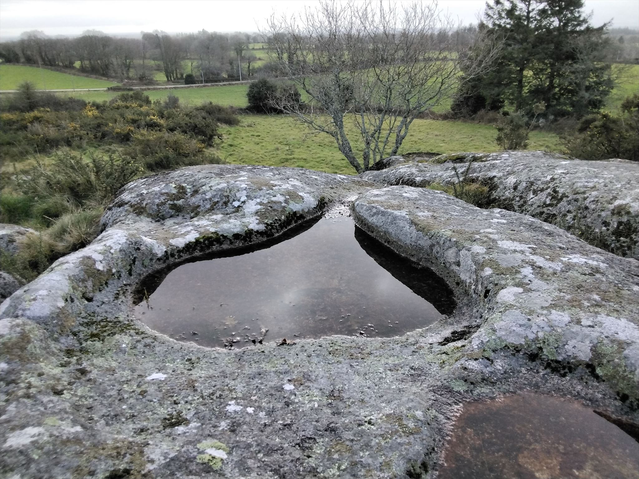
Cet immense rocher est creusé de tout son long par de longues stries colonisées par les spergulaires des rochers, et de larges cupules, surnommées localement les "marmites du diable".
This immense rock is dug all along by long streaks colonized by the spergulars of the rocks, and large cupules, nicknamed locally the "potholes of the devil".
Pas de diablerie, juste un effet de météorisation / No devilry, just a bloat effect
En géomorphologie, la météorisation, appelée aussi altération météorique, altération atmosphérique ou altération climatique, est l’ensemble des processus mécaniques, physico-chimiques ou biologiques de réduction élémentaire des roches et des minéraux à la surface de la Terre par les agents météoriques (appelés aussi météores, il s'agit principalement de l'eau, des gaz atmosphériques et des variations de température), mécaniques ou biologiques.
In geomorphology, weathering, also called meteoric weathering, atmospheric weathering or climatic weathering, is the set of mechanical, physico-chemical or biological processes of elemental reduction of rocks and minerals on the Earth's surface by weathering agents (called also meteors, it is mainly water, atmospheric gases and temperature variations), mechanical or biological.
Cette attaque de la roche en place s'effectue au contact de l'atmosphère ou à son voisinage, et les phénomènes météorologiques en contrôlent étroitement la marche. Aussi la qualifie-t-on de météorisation, pour la distinguer de l'érosion qui implique un transport. C'est cette action qui va ainsi creuser ces trous dans la roche et suivant la réaction de la roche, créer des formes particulières, trous, stries ou failles ... en fonction de la composition de la roche et de sa résistance à ces agents météoriques.
This attack on the bedrock takes place in contact with the atmosphere or in its vicinity, and meteorological phenomena closely control its progress. It is therefore called weathering, to distinguish it from erosion, which involves transport. It is this action that will thus dig these holes in the rock and, depending on the reaction of the rock, create particular shapes, holes, streaks or faults... depending on the composition of the rock and its resistance to these agents. meteoric.
Observez bien la roche et ces effets de météorisation / Take a look at the rock and these weathering effects

Pour valider cette earthcache il vous faudra vous rendre aux 4 waypoints indiqués pour y répondre aux différentes questions. Pour valider votre découverte il faudra apporter vos réponses à ces différentes questions en reprenant bien les différents waypoints qui y sont associés :
To validate this earthcache you will have to go to the 4 waypoints indicated to answer the various questions. To validate your discovery, you will have to provide your answers to these different questions by taking up the different waypoints associated with it:
WP1 : La roche a été altéré par la météorisation, mais à quel point ? Par rapport à ce que vous avez pu voir aux coordonnées de cette earthcache décrivez les effets de météorisation. Quel élément vous permet de valider votre observation ? The rock has been altered by weathering, but how much? Compared to what you could see at the coordinates of this earthcache describe the weathering effects. What element allows you to validate your observation?
WP2 : Ici aussi la roche a été profondément altérée. Décrivez ce que vous observer et expliquez comment à pu se mettre en place ce phénomène dans la roche. Here too the rock has been deeply altered. Describe what you observe and explain how this phenomenon could have taken place in the rock.
WP3 : Ici la roche semble coupée en 2. Quel phénomène peut expliquer ceci ? Quelle est l'orientation géographique (Nord, Est, Sud, Ouest) de cette coupure ? Here the rock seems to be cut in two. What phenomenon can explain this? What is the geographical orientation (North, East, South, West) of this cut?
WP4 : Encore une fois vous approchez d'un espace altérée de la roche. Quelle est la forme de cette "cuvette", comment a elle pu se former ainsi ? Again you are approaching an altered area of rock. What is the shape of this "bowl", how could it have formed like this?
Une photo souvenir de vous au pied de ce monolithe sera la bienvenue mais n'est pas obligatoire pour valider votre découverte.
 Pour rappel dans les earthcaches il n'y a pas de boîte à trouver. Il vous faut juste vous rendre sur place et répondre aux questions d'observation qui vous sont posées.
Vous pouvez loguer votre découverte mais devez m'envoyer vos réponses. Je vous recontacterais en cas de grosses erreurs.
A souvenir photo of you at the foot of this monolith will be welcome but is not mandatory to validate your discovery.
As a reminder in the earthcaches there is no box to find. You just have to go there and answer the observation questions that are asked of you. You can log your discovery but must send me your answers. I will contact you again in case of big errors.
Sources : carte géologique à 1/50 000 ROSPORDEN & Geoportail