
NEUVY / BRACIEUX
 Les argiles et sables de Sologne
Cette earthcache a pour but de vous faire découvrir les argiles et sables de Sologne de la zone de la forêt de Boulogne située sur les communes de Neuvy et de Bracieux.
La colonne stratigraphique du Loir et Cher ci-dessous représente de manière synthétique la succession chronologique des formations sédimentaires (ou « couches ») du département. Elle constitue la base permettant de reconstituer l’histoire géologique.
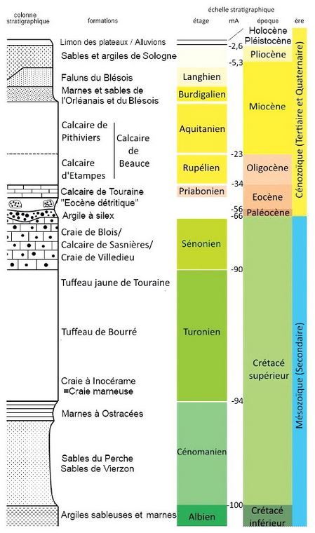
La earthcache qui nous intéresse présentement traite donc, comme nous pouvons le constater, de l'une des formations les plus récentes en terme de géologie.
Le site d'observation:
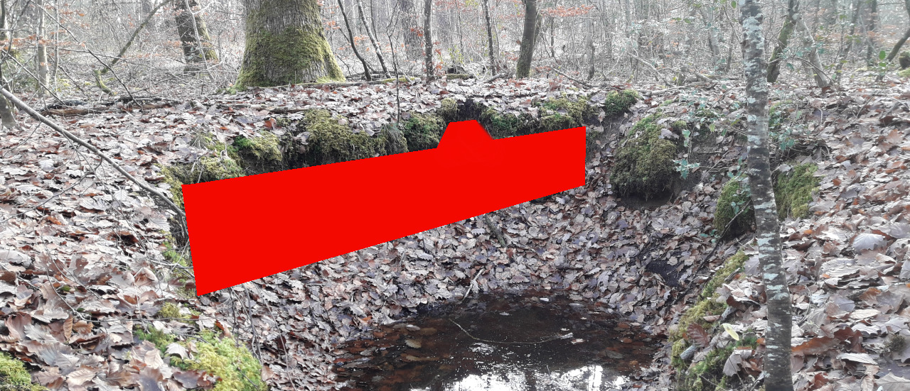
Nous sommes ici face à l'une des nombreuses sources de la forêt domaniale de Boulogne. Grâce à l'érosion que génère cette dernière, nous pouvons observer la couche superficielle du sol de Sologne comme si nous étions face à une mini carrière laissant apparaitre un front de coupe.
Situation géographique:
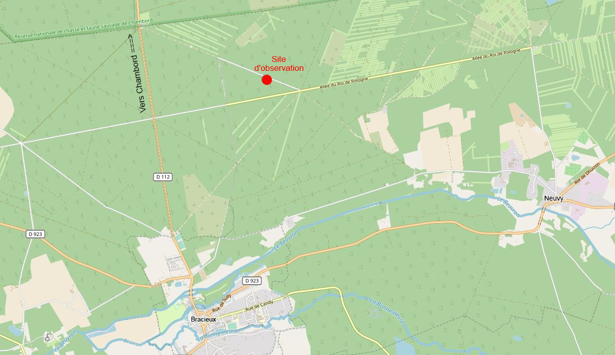
En limite de trois zones de la forêt dites de la Billoterie, de la Héronnière et Chambord, en bordure de l'allée du Prince de Wagram, en plein coeur de la forêt domaniale de Boulogne (Sologne occidentale).
Plan géologique de la zone:
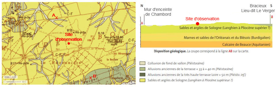
A l’échelle de la Sologne, les proportions de sables et d’argiles sont extrêmement variables d’un niveau à l’autre, et les divers niveaux sont disposés en lentilles anastomosées. La formation a une épaisseur moyenne de 20 à 50 m. Litages obliques, dispositions lenticulaires, forme des quartz indiquent ici une sédimentation fluviatile.
La coupe ci-dessus montre la situation de la formation Sables et Argiles de Sologne dans la partie nord-ouest de la Sologne (d’après la carte géologique de Bracieux, modifié).
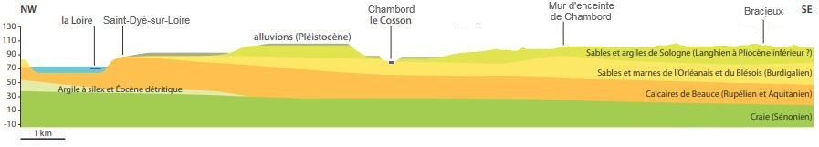
Depuis la fin du Pliocène et pendant le Pléistocène, l’épaisseur de la formation a été progressivement réduite, par l’érosion accompagnant les incisions successives de la Loire et des petites rivières, Cosson notamment. Ces incisions, liées aux cycles glaciaires, ont également laissé en terrasses les matériaux des nappes d’alluvions successives.
Matériaux et formation des sables et argiles de Sologne:
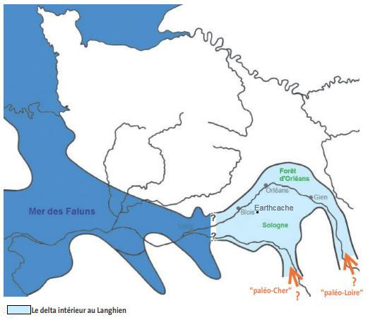
Les matériaux de la formation proviennent de l’érosion des roches granitiques et métamorphiques du Massif central. Ils ont été transportés par une « paléo-Loire », et sans doute un « paléo-Cher », dans une vaste dépression subsidente à fond irrégulier, dépression correspondant en grande partie à la Sologne d’aujourd’hui.
L’étendue de la zone d’épandage (Forêt d’Orléans, Sologne centrale et Sologne occidentale…) conduit à imaginer un delta intérieur comparable à celui du Niger actuel, delta dans lequel les matériaux déversés ont été repris par les crues et transportés plus en aval dans des chenaux à géométrie changeante en direction de la Mer des Faluns transgressive en Bretagne et Anjou depuis le Burdigalien. Cette mer s’est avancée jusqu’en Sologne (Pontlevoy, Soings-en Sologne…) au Langhien (vers - 15 millions d’années).
Dépourvus de faune vertébrée fossile, les Sables et argiles de Sologne ne sont pas datables par biostratigraphie. Superposés aux Sables et marnes de l’Orléanais et du Blésois, datés Burdigalien à début Langhien (- 20 à - 15 millions d’années) par des fossiles, ils sont considérés comme Langhien (Miocène moyen) et post-Langhien (Miocène supérieur). La partie supérieure de la formation est estimée Miocène terminal à Pliocène inférieur (autour de - 5 millions d’années) et correspondrait à un écoulement Nord-Sud vers la Manche à l’emplacement de l’actuelle vallée de la Seine (cette paléogéographie n’est pas représentée sur la figure du delta intérieur au Langhien ci-dessus).
(Sources: site internet du CDPNE - Comité Départemental de la Protection de la Nature et de l’Environnement)

LES QUESTIONS
La lecture attentive du descriptif de la cache, ainsi qu'une observation des éléments de terrain et un peu de déduction sont normalement suffisants pour répondre aux questions de cette EarthCache.
- Question 0: Prenez une photo de vous ou d'un élément vous identifiant avec la source ou son affleurement en arrière plan.
Cette photo devra au choix nous être transmise avec les réponses ou être ajoutée à votre log (si vous la postée dans votre log, merci de la mettre en noir et blanc).
- Question 1 : Décrivez le matériau constituant l'affleurement sous les zones rouges de la photo ci-dessous (couleur, texture, taille du grain).
- Question 2 : Au toucher, comment l'affleurement est-il: friable ou plutôt "collant"? Le fait de l'humidifier change-t-il quelque-chose? Qu'en concluez-vous?
- Question 3 : En vous aidant du descriptif, datez la formation géologique face à vous et expliquez brièvement les raisons de sa présence en Sologne.
Vous pouvez vous loguer sans attendre notre confirmation, mais vous devez nous envoyer les réponses en même temps soit par mail via notre profil (Moules de Bouchu), soit via la messagerie geocaching.com (Message Center).
S'il y a des problèmes avec vos réponses nous vous en ferons part. Les logs enregistrés sans réponses et la photo seront supprimés.
Rappel concernant les « Earthcaches »: Il n'y a pas de conteneur à rechercher ni de logbook à renseigner. Il suffit de se rendre sur les lieux, de répondre aux questions ci-dessus et de nous renvoyer les réponses.
NEUVY / BRACIEUX
 Clays and sands of Sologne
The purpose of this earthcache is to make you discover the clays and sands of Sologne of the Boulogne forest area located in the municipalities of Neuvy and Bracieux.
The stratigraphic column of the Loir et Cher below represents in a synthetic way the chronological succession of the sedimentary formations (or “layers”) of the department. It forms the basis for reconstructing geological history.
The earthcache that interests us now therefore deals, as we can see, with one of the most recent formations in terms of geology.
The observation site:
We are here facing one of the many sources of the national forest of Boulogne. Thanks to the erosion generated by the latter, we can observe the surface layer of the soil of Sologne as if we were facing a mini quarry revealing a cutting front.
Geographic location:
On the edge of three areas of the forest known as Billoterie , Héronnière and Chambord , along the Allée du Prince de Wagram , in the heart of the national forest of Boulogne (western Sologne).
Geological plan of the area:
On the Sologne scale, the proportions of sand and clay are extremely variable from one level to another, and the various levels are arranged in anastomosed lenses. The formation has an average thickness of 20 to 50 m. Oblique bedding, lenticular arrangements, quartz shape here indicate fluvial sedimentation.
The above section shows the location of the Sables et Argiles de Sologne formation in the north-western part of Sologne (according to the geological map of Bracieux, modified).
Since the end of the Pliocene and during the Pleistocene, the thickness of the formation has been gradually reduced, by the erosion accompanying the successive incisions of the Loire and of the small rivers, Cosson in particular. These incisions, linked to glacial cycles, also left the materials of successive alluvial layers in terraces.
Materials and formation of Sologne sands and clays:
The formation materials come from the erosion of granitic and metamorphic rocks of the Massif Central. They were transported by a "paleo-Loire", and undoubtedly a "paleo-Cher", in a vast subsiding depression with irregular bottom, depression corresponding in large part to the Sologne of today.
The extent of the spreading area (Orléans Forest, central Sologne and western Sologne, etc.) leads to imagine an interior delta comparable to that of the current Niger, a delta in which the materials spilled were taken up by floods and transported more downstream in changeable geometry channels towards the Mer des Faluns transgressive in Brittany and Anjou from the Burdigalien. This sea advanced as far as Sologne (Pontlevoy, Soings-en Sologne ...) at Langhien (around - 15 million years).
Devoid of fossil vertebrate fauna, the Sands and Clays of Sologne cannot be dated by biostratigraphy. Superimposed on the sands and marls of Orléanais and Blésois, dated Burdigalian to early Langhien (- 20 to - 15 million years ago) by fossils, they are considered as Langhien (Middle Miocene ) and post-Langhien (Upper Miocene). The upper part of the formation is estimated late Miocene to Lower Pliocene (around - 5 million years ago) and would correspond to a North-South flow towards the English Channel at the site of the present valley of the Seine (this paleogeography n is not shown in the figure of the interior delta in the Langhien above).
(Sources: website of CDPNE - Comité Départemental de la Protection de la Nature et de l’Environnement)
THE QUESTIONS
Careful reading of the description of the cache, as well as an observation of the terrain elements and a little deduction are normally sufficient to answer the questions of this EarthCache.
- Question 0: Take a photo of yourself or something that identifies you with the source or its outcrop in the background.
This photo must either be sent to us with the answers or be added to your log (if you posted it in your log, please put it in black and white).
- Question 1 : Describe the material constituting the outcrop under the red areas in the photo below (color, texture, grain size).
- Question 2 : To the touch, how is the outcrop crumbly or rather "sticky"? Does humidifying it make a difference? What do you conclude?
- Question 3 : Using the description, date the geological formation in front of you and briefly explain the reasons for its presence in Sologne.
You can log this cache without waiting for our confirmation, but you must send us the answers at the same time, by e-mail via our profile (Moules de Bouchu) or by the system of Message Center of geocaching.com.If there is a problem with your answers we will notify you. The logs recorded without answers and the photo will be deleted.
Reminder concerning "Earthcaches": there is neither a container to look for nor a logbook to sign. One need only go to the location, answer to the differents questions and send us the answers.