De manière général, les ensembles dunaires font partie des formations superficielles (formations qui sont relativement récentes à l'échelle géologique). Il existe des dunes éoliennes, hydroliques ou fluviatiles (appelées "barres").
La dune présente différents compartiments, dont voici les principaux :
- La dune du haut de la plage : on y trouve la laisse de mer (algues, coquillages, bois).
- La dune mobile, ou dune blanche, avec des plantes devant résister à l’ensablement (chiendent, oyat, chardon bleu, euphorbe, laîche, liseron, oeillets, giroflées).
- La dune fixée, ou dune grise, au sol plus riche : Elle porte de nombreuses plantes qui le sable (gaillet, luzerne, ephedra ou raisin de mer, serpolet, immortelle, orpin, rose primpenelle, pavot cornu).
Enfin la dune boisée à pin maritime et chêne vert permettant une fixation définitive de celle-ci
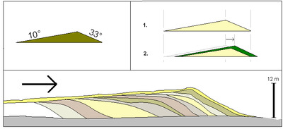
Les dunes se forment dans des zones où le sable est abondant et non fixé par la végétation (désert, plage, lit fluvial à l'étiage). Le sable est érodé et pris en charge par le vent (déflation). Il est transporté au ras du sol par saltation, puis s'accumule quand la compétence du vent chute (versant sous le vent). Une dune peut se déplacer par érosion du versant au vent et accumulation sur le versant opposé.
_____________________________________________________________________________________________________________
In general, dune sets are part of surface formations (formations that are relatively recent on a geological scale). There are wind, hydrolic or fluvial dunes (called "bars").

The dune has different compartments, the main ones of which are:

- The dune at the top of the beach: there is the sea leash (seaweed, shells, wood).

- The mobile dune, or white dune, with plants that must resist silting up (quackgrass, marsh grass, blue thistle, spurge, sedge, bindweed, carnations, wallflowers).

- The fixed dune, or gray dune, with richer soil: It bears many plants which sand it (bedstraw, alfalfa, ephedra or sea grape, thyme, immortelle, stonecrop, primpenelle rose, horned poppy).

And finally the wooded dune with maritime pine and holm oak allowing a definitive fixation of this one.

The dunes are formed in areas where sand is abundant and not fixed by vegetation (desert, beach, river bed at low water). The sand is eroded and carried by the wind (deflation). It is carried low to the ground by saltation, then accumulates when the wind skill drops (downwind slope). A dune can move by erosion of the windward slope and accumulation on the opposite slope.
_______________________________________________________________________________________________________________
La formation dunaire / The dune formation.
Les dunes sans végétation, sont constamment en mouvement ; la mise en place d'une végétation arbustive spécifique (Oyats, Immortelles,..), puis en arrière d'une végétation faite de résineux ou de chênes verts permet la stabilisation dunaire.
_____________________________________________________________________________________________________________________
Without vegetation, the dunes are constantly in motion; it is the establishment of a specific shrub vegetation (sea rocket, Oyats, Immortelles, ..), then behind a vegetation made of conifers or holm oaks that will allow its stabilization.
► Sources bibliographiques / Bibliographical sources
.
Les Questions / The Questions
La lecture attentive du descriptif de la cache, ainsi qu'une observation des éléments de terrain et un peu de déduction sont normalement suffisants pour répondre aux questions de cette EarthCache.
A careful reading of the description of the cache, as well as observation of terrain features and some deduction is usually sufficient to answer questions of this EarthCache.
Point 1 : N 45° 43.851' W 1° 14.262'
- Question 1 : Dans la photo ci-dessous, nommez les différents compartiments 1, 2, 3, 4, 5
- Question 1 : In the photo below, name the different compartments 1, 2, 3, 4, 5 .
- Question 2 : De quoi souffre le massif forestier ? Quelles sont les élément relatifs à cette dégradation ?
- Question 2 : What is the forest area suffering from ? What are the elements relating to this degradation ?
Point 2 : N 45° 43.871' W001° 14.320'
- Question 3 : Vous voici au sommet de la dune, selon vous quelle est la granulométrie
du sable ?
- Question 3 : Here you are at the top of the dune, according to you what is the grain size
sand?
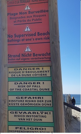
- Question 4 : Prenez une photo de vous, ou d'un objet vous représentant, avec le panneau bien visible.
- Question 4 : Take a picture of yourself, or an object representing you, with the watchtower clearly visible.
Vous pouvez vous loguer sans attendre notre confirmation, mais vous devez nous envoyer les réponses en même temps soit par mail via notre profil , soit via la messagerie geocaching.com (Message Center).
S'il y a des problèmes avec vos réponses nous vous en ferons part. Les logs enregistrés sans réponses seront supprimés.
You can log this cache without waiting for our confirmation, but you must send us the answers at the same time, by e-mail via our profile or by the system of Message Center of geocaching.com.
If there is a problem with your answers we will notify you. The logs recorded without answers will be deleted.