La Earhcache / The Earhcache
► Contexte géologique local
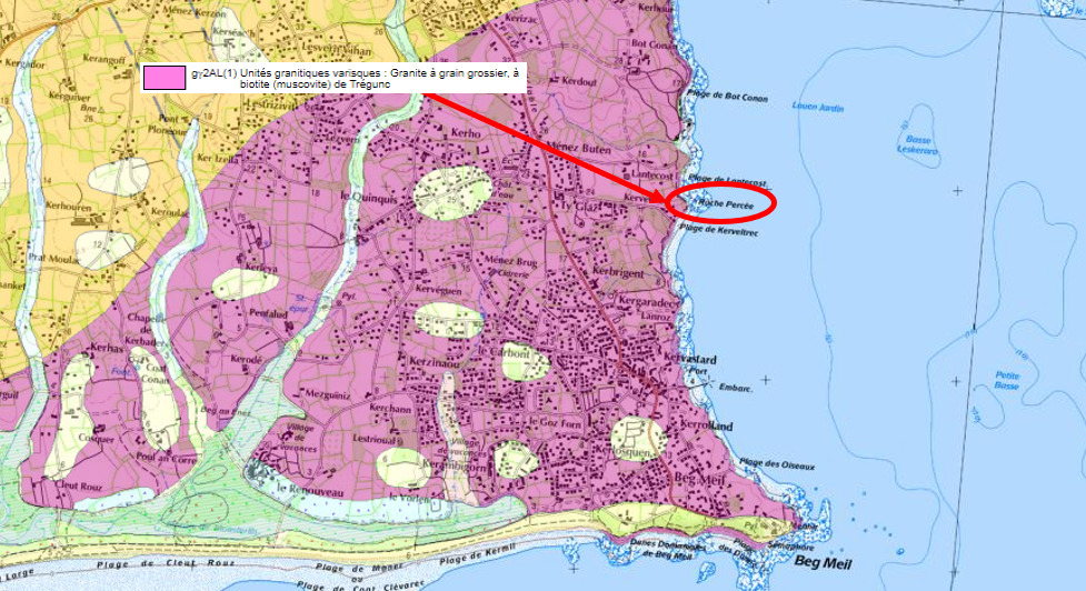
La région de Beg-Meil est issue d'un vaste batholite intrusif, le granite de Trégunc.
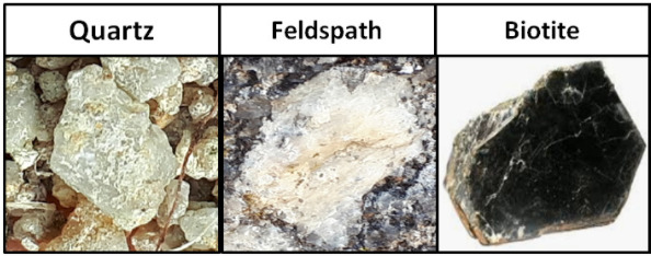
Cette formation plutonique très homogène est à texture grenue (grain moyen ou grossier) et présente une composition QFM classique :
- Q comme Quartz (40 %) : translucide parfois transparent, ce minéral est de couleur gris sans facette.
- F comme Feldspath (55%) : ce minéral est blanchâtre et opaque.
- M comme Mica : fines paillettes brillantes principalement de biotite (5%), un mica noir de composition ferro-magnésienne.
► Les facteurs d'altération et d'érosion du granite
Les principaux agents d’altération du granite de Tregunc sont :
• l’eau : elle agit par hydratation (gonflement des feuillets des micas qui les désolidarisent) ou hydrolyse (oxydation du fer).
• les végétaux : les racines agissent dans les diaclases par hydrolyse (acidification du milieu).
Chacun des minéraux du granite réagit différemment à l’altération :
- La biotite : A cause de la présence de fer dans sa composition, elle s'hydrolyse très vite.
- Les feldspaths : Par hydrolyse, ils se transforment en argiles mais restent assez résistants.
- Le quartz : Il est inaltérable. Une fois séparé des autres éléments, il fournit l'essentiel du sable.
► Des diaclases aux arches, l'altération verticale
Lors de la solidification du granite dans l'écorce terrestre, sa grande rigidité entraine la formation de nombreuses fissures, les diaclases qui facilitent l’altération en permettant à l’eau de circuler et aux racines des plantes de pénétrer la roche.

Ces lignes de faiblesse se transforment par altération/érosion en creusements de grottes ou d'arches.
► Les cupules, altération horizontale
Une cupule est un creux de dissolution oblongue se produisant sur des surfaces horizontales.
Leur origine est attribuée aux phénomènes d'érosions mécanique et chimique dus à la présence quasi permanente d'eau ayant un action d'hydrolyse sur des minéraux sensibles (biotite).

► L’arène granitique, produit final de l'altération
Un granite altéré puis « pourri » présente une fragilisation progressive, une surface plus rugueuse et un aspect mat des cristaux de feldspaths.
Quand on le frotte des grains s'en détachent donnant une arène granitique.
Il s'agit des minéraux non encore altérés :
• des grains de quartz gris translucides inaltérables.
• des grains de feldspaths blancs opaques restants plus ou moins altérés.

► Local geological context
The Beg-Meil region comes from a vast intrusive batholith, the Trégunc granite.
This very homogeneous plutonic formation has a grainy texture (medium or coarse grain) and presents a classic QFM composition:
- Q for Quartz (40%): translucent sometimes transparent, this mineral is gray in color without facet.
- F for Feldspar (55%): this mineral is whitish and opaque.
- M for Mica: fine shiny flakes mainly of biotite (5%), a black mica of ferro-magnesian composition.
► Granite weathering and erosion factors
The main weathering agents of Tregunc granite are:
• water: it acts by hydration (swelling of the micas layers which separate them) or hydrolysis (oxidation of iron).
• plants: the roots act in the joints by hydrolysis (acidification of the environment).
Each of the minerals in granite reacts differently to weathering:
- Biotite: Due to the presence of iron in its composition, it hydrolyses very quickly.
- Feldspars: By hydrolysis, they turn into clays but remain quite resistant.
- Quartz: It is unalterable. Once separated from the other elements, it provides most of the sand.
► From joints to arches, vertical alteration
As granite solidifies in the earth's crust, its great rigidity causes the formation of numerous cracks, joints that facilitate weathering by allowing water to circulate and plant roots to penetrate the rock.
These lines of weakness are transformed by weathering / erosion into excavations of caves or arches.
► The cups, horizontal alteration
A well is an oblong hollow of dissolution occurring on horizontal surfaces.
Their origin is attributed to the phenomena of mechanical and chemical erosion due to the almost permanent presence of water having a hydrolysis action on sensitive minerals (biotite).
► The granite arena, the end product of weathering
A weathered and then “rotten” granite exhibits progressive embrittlement, a rougher surface and a matt appearance of feldspar crystals.
When rubbed, grains come off giving a granite arena.
These are minerals not yet altered:
• unalterable translucent gray quartz grains.
• opaque white feldspar grains remaining more or less altered.
► Sources bibliographiques / Bibliographical sources
Les Questions / The Questions
Questions pour valider :"Arches et Altérations à la Pierre Percée"
Questions to validate: "Arches and Alterations at the Pierre Percée"
!!! ATTENTION CACHE UNIQUEMENT ACCESSIBLE MAREE BASSE !!!
!!! WARNING EARTHCACHE ONLY ACCESSIBLE LOW TIDE !!!
Avant de vous y aventurer, consulter l'horaire des marées :
Before you go, check the tide schedule:
Horaires des marées à Beg-meil.
- Question 0 : Prenez une photo de vous ou d'un élément vous appartenant avec l'arche.
Cette photo devra au choix nous être transmise avec les réponses ou être ajoutée à votre log.
-Question 0 : Take a photo of yourself or something you own with the ark.
This photo must either be sent to us with the answers or added to your log.
Point 1 : N 47° 52.180' W 3° 59.063'
Vous voici sous une vaste arche de granite. Approchez-vous de la roche sous l'arche.
Here you are under a vast granite arch. Approach the rock under the arch.
- Question 1 : Décrivez la roche des "piliers" de l'arche et dites quel minéral QFM semble manquer.
- Question 1: Describe the rock of the "pillars" of the arch and say which mineral QFM appears to be missing.
- Question 2 : Que se passe t-il quand vous frottez ces "piliers" ? Qu'obtenez-vous ?
- Question 2: What happens when you rub these "pillars"? What do you get?
Point 2 : N 47° 52.188' W 3° 59.073'
Allez au WP2 puis dos à la mer, observez la falaise devant vous.
Go to WP2 then with your back to the sea, observe the cliff in front of you.
- Question 3 : Décrivez les formes d'altération de la falaise. Si celle-ci se poursuit, quelle forme pourrait-on obtenir ?
- Question 3: Describe the forms of weathering of the cliff. If this continues, what form could we obtain?
Point 3 : N 47° 52.190' W 3° 59.066'
A ce point, vous pouvez voir devant vous, au sol, d'autres formes d'altérations.
At this point, you can see in front of you, on the ground, other forms of deterioration.
- Question 4 : Décrivez et nommez ces structures. Comment se sont-elles mises en place ?
- Question 4: Describe and name these structures. How did they come into place?
Vous pouvez vous loguer sans attendre notre confirmation,
mais vous devez nous envoyer les réponses en même temps soit par mail via notre profil (
fafahakkai), soit via la messagerie geocaching.com (Message Center).
S'il y a des problèmes avec vos réponses nous vous en ferons part.
Les logs enregistrés sans réponse seront supprimés.
You can log this cache without waiting for our confirmation, but you must send us the answers at the same time, by e-mail via our profile (fafahakkai) or by the system of Message Center of geocaching.com.
If there is a problem with your answers we will notify you. The logs recorded without answers will be deleted.
Rappel concernant les « Earthcaches »: Il n'y a pas de conteneur à rechercher ni de logbook à renseigner. Il suffit de se rendre sur les lieux, de répondre aux questions ci-dessus et de nous renvoyer les réponses.
Reminder concerning "Earthcaches": there is neither a container to look for nor a logbook to sign. One need only go to the location, answer to the differents questions and send us the answers.