 La Sarthe a creusé dans la granodiorite une vallée encaissée et sinueuse pouvant atteindre plus de 40 m de profondeur.
 Un circuit à pied depuis le pont jusqu’à la chapelle en passant par l’église permet d’observer les rives escarpées de la Sarthe et la dissymétrie des versants au niveau des méandres.
Le centre du village de Saint-Céneri est bâti dans une longue boucle étroite de la Sarthe. Les rives de la Sarthe sont escarpées ou en pente douce selon leur position dans les méandres. La Sarthe coule de l’Est vers l’Ouest.
 The Sarthe has carved out a steep, winding valley in the granodiorite that can reach more than 40 m in depth.
A walk from the bridge to the chapel via the church allows you to observe the steep banks of the Sarthe and the asymmetry of the slopes at the level of the meanders.
The center of the village of Saint-Céneri is built in a long narrow loop of the Sarthe. The banks of the Sarthe are steep or gently sloping depending on their position in the meanders. The Sarthe flows from east to west.
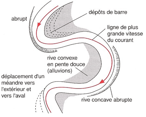
Formation des méandres
Dans un méandre (profils du haut et du bas), l'érosion se fait sur la rive concave, à pente raide, là où la vitesse du courant est la plus grande, alors que le dépôt se fait sur l'autre rive, convexe, là où la vitesse du courant est plus faible, formant une terrasse alluviale (ou barre de méandre). Le couple érosion-dépôt entraîne une migration latérale du méandre, causant un élargissement de la vallée au stade de maturité et une remobilisation des sédiments au stade de vieillesse de la vallée.
On oppose traditionnellement la rive concave (rive externe, attaquée par l'érosion, souvent en pente forte) et la rive convexe (rive intérieure, généralement en pente faible et constituée d'alluvions déposées par le cours d'eau), ces deux rives alternant d'un méandre à l'autre.
Meander formation
In a meander (top and bottom profiles), erosion occurs on the concave bank, with a steep slope, where the speed of the current is the greatest, while the deposit is on the other bank, convex , where the speed of the current is lower, forming an alluvial terrace (or meander bar). The erosion-deposit pair causes lateral migration of the meander, causing a widening of the valley at the stage of maturity and a remobilization of the sediments at the stage of old age of the valley.
Traditionally, the concave shore (external shore, attacked by erosion, often on a steep slope) and the convex shore (interior shore, generally on a low slope and made up of alluvium deposited by the watercourse) are opposed. alternating from one meander to another.
L'érosion fluviale ou type d'eaux de ruissellement creusent les vallées.
Les vallées creusées en terrains meubles et homogènes prennent un profil transversal en V. En terrains durs et massifs ( calcaires, granites), la tendance est à l’enfoncement vertical ( Gorges et canyons). La profondeur, la largeur et les formes de ces dernières se modifient avec le temps.
Les deux types de profil de vallées
Le stade de jeunesse d'une vallée fluviale se caractérise par du creusement qui conduit à la formation d'une vallée étroite en forme de V; les reliefs sont accentués le long du cours d'eau et on retrouve chutes, cascades et rapides.
A l'étape de la maturité, le cours d'eau aplanit ses reliefs et diminue son gradient de pente; il commence alors à éroder latéralement, élargissant la vallée et créant, par ses dépôts, une plaine d'inondation. Cette dernière se construit par l'apport constant de sédiments issus de l'érosion en amont et par l'épandage dans la vallée de ces sédiments durant les périodes de débordement dues aux crues.
Le stade de vieillesse de la vallée est atteint lorsque celle-ci est beaucoup plus large que les plus larges méandres du cours d'eau. A noter que les tributaires du cours d'eau principal contribuent eux aussi à aplanir les reliefs adjacents.
Fluvial erosion or a type of runoff digs up the valleys.
The valleys carved out of loose and homogeneous terrain take on a transverse V-shaped profile. In hard and massive soils (limestone, granite), the tendency is towards vertical depression (gorges and canyons). The depth, width and shape of the latter change over time.
The two types of valley profile
The youthful stage of a river valley is characterized by digging which leads to the formation of a narrow V-shaped valley; the reliefs are accentuated along the watercourse and we find waterfalls, waterfalls and rapids.
At the stage of maturity, the watercourse flattens its reliefs and decreases its slope gradient; it then begins to erode laterally, widening the valley and creating, through its deposits, a flood plain. The latter is built by the constant supply of sediments resulting from erosion upstream and by the spreading in the valley of these sediments during periods of overflow due to floods.
The old age of the valley is reached when it is much wider than the widest meanders of the river. Note that the tributaries of the main watercourse also contribute to leveling out the adjacent reliefs.
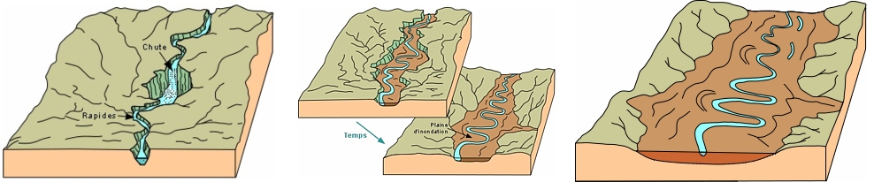
Formation d'une vallée, les différents stades de maturité
Questions pour valider cette earthcache :
D'après vos observations et à l'aide du desciptif,
Questions to validate this earthcache:
Based on your observations and using the description,
Question 0
Joindre à votre log (PAS à vos réponses) une photo de vous, votre GPS, votre GC perso ou tout autre objet vous représentant dans le jeu à l'un des stages. Sans montrer les réponses bien sûr !
Les simples photos de paysage ou capture d'écran de votre position ne permettent pas de valider cette condition de log.
Cette tâche est obligatoire et autorisée par les guidelines mises à jour en juin 2019.
Attach to your log (NOT to your answers) a photo of you, your GPS, your personal GC or any other object representing you in the game at one of the stages. Without spoilers of course !
The simple photos of the landscape or screenshot of your position do not validate this log condition.
This task is mandatory and allowed by the guidelines updated in june 2019.
Question 1 Stage 1
Observez la rive de part et d'autre du pont avec l'Eglise dans votre dos. Décrivez le relief. D'après vos observations, pensez-vous que le lit de la rivière se soit déplacé ?
Observe the shore on either side of the bridge with the Church behind your back. Describe the relief. Based on your observations, do you think the bed of the river has shifted ?
Question 2 Stage 2
Observez la topographie autour de vous et réalisez un croquis du méandre avec au minimum l'indentification des éléments suivants : Chapelle, Fontaine, Rivière, Rive convexe, Rive Concave, pente escarpée, pente douce, zone plane à alluvions récents, boisée, herbue. Laissez parler votre vision artisitique !
Photographiez votre croquis pour me le faire parvenir. Attention, j'attends un croquis réalisé de votre main, avec votre interprétation. Evidement le croquis ne doit pas figurer dans votre log.
Chaque joueur souhaitant loguer cette Earthcache doit envoyer son propre croquis.
!! 1 PSEUDO = 1 CROQUIS !!
Observe the topography around you and draw a sketch of the meander with at least the identification of the following elements: Chapel, Fountain, River, Convex bank, Concave bank, steep slope, gentle slope, flat area with recent alluvium, woodland, grass. Let your artistic vision speak for itself !
Photograph your sketch to send it to me. Please note, I'm waiting for a sketch made with your hand, with your interpretation. Obviously the sketch should not appear in your log.
Each player wishing to log this Earthcache must send their own sketch.
!! 1 PSEUDO = 1 SKETCH !!
Envoyez-moi vos propositions de réponses soit via mon profil, soit via la messagerie geocaching.com (Message Center) PUIS loguez cette cache "Found it", je vous contacterai en cas de problème.
Assurez vous de répondre à TOUTES les questions ! La condition principale pour loguer une Earthcache étant de répondre aux questions posées dans le descriptif, tout log "Found it" enregistré sans envoi préalable de vos propositions de réponses sera supprimé. Il en sera de même pour les logs enregistrés sans la photo requise.
Send me your proposals for answers either via my profile or via the geocaching.com messaging (Message Center) THEN log this cache "Found it", I will contact you in case of problem.
Make sure to answer ALL questions ! The main condition to log an Earthcache is to answer the questions asked in the description, any log "Found it" registered without prior submission of your proposals of answers will be deleted. It will be the same for logs saved without the required photo.