!!! ATTENTION !!!
CETTE EARTHCACHE EST ACCESSIBLE À MARÉE BASSE UNIQUEMENT
Pour vous renseigner avant de venir tenter de trouver cette cache cliquez ici.
 KERVOYAL
 Le Pont Saint-Sauveur
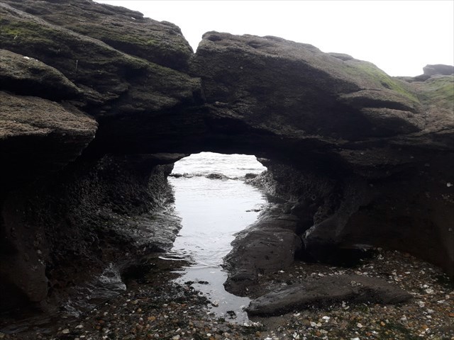
Cette earthcache a pour but de vous faire découvrir le Pont Saint-Sauveur qui est une arche naturelle située dans les rochers de la pointe de Kervoyal.
La légende du Pont Saint-Sauveur:
Cette curieuse arche naturelle et rare serait en fait le fruit d’un malentendu divin qui aurait eu lieu au Vème siècle: Un moine, Saint-Sauveur, était venu évangéliser Kervoyal, mais la population locale « qui ne croyait pas à ces choses là… » le chassa avec des pierres. Il se cacha dans les rochers de la pointe et à l’aide de son bâton tapa sur les rochers, et soudain le pont se forma,il put se mettre à l’abri le temps que la marée remonte et quitta le village en proférant:« Redon grandira, Kervoyal périra ! » car il avait l’intention de remonter la Vilaine.
(Sources: Damganhistoire.fr et Les Amis de Kervoyal)

Les arches naturelles:
Une arche naturelle ou un pont naturel est une formation géologique constituée d'une arche rocheuse, creusée naturellement par l'érosion.
Le choix du terme « arche » ou « pont » est quelque peu arbitraire. La Natural Arch and Bridge Society définit un pont comme un sous-type d'arche, dont la formation est en rapport avec l'action de l'eau. À l'opposé, le Dictionary of Geological Terms définit un pont naturel comme une « arche naturelle qui enjambe une vallée suite à l'érosion ».
La formation des arches naturelles peut être le résultat de 4 types d'érosion: l'érosion marine, l'érosion par cryoclastie et thermoclastie, l'érosion par les cours d'eau et l'effondrement de grottes (bien que l'effondrement de grottes peut également être la conséquence de l'un des trois autres types d'érosion).
Dans le cas du Pont Saint-Sauveur, il s'agit d'une arche marine.
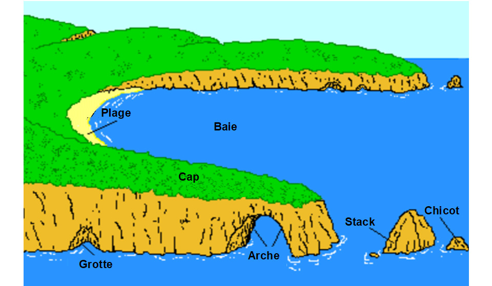
Les arches naturelles par érosion marine:
Une arche marine peut se former de deux principales manières en fonction des conditions géologiques.
Lorsque les couches de roche composées d'une alternance de roches dures et tendres sont perpendiculaires à la côte, l'érosion différentielle qui en résulte par l'action des vagues va dégager ces roches résistances. Il en résulte des promontoires dont la base est sapée par les vagues, leur énergie étant concentrée en certains endroits par un phénomène de diffraction. Il peut ainsi se créer une arche marine qui donne naissance à un stack une fois effondrée. Le London Arch en Australie est un exemple de ce type d'arche.
Lorsque ces mêmes couches de roche sont perpendiculaires à la côte, les vagues vont percer les couches de roche dures et éroder les roches tendres qui se trouvent derrière. Lorsque l'arche marine ainsi créée s'effondre, elle donne naissance à une anse.
 Formation d'une arche naturelle
Les rochers de la pointe de Kervoyal:
Le sous-sol du département du Morbihan est tout entier contenu dans une entité géologique connue sous le nom de Massif Armoricain qui représente une des parties les plus anciennes et les plus complexes du territoire français. Ce sous-sol est constitué de roches variées qui caractérisent une ancienne chaîne de montagne aujourd’hui fortement érodée : la Chaîne Hercynienne qui s’est formée au Paléozoïque entre 450 et 300 millions d’années.Le type de roche (sédimentaire, magmatique, métamorphique) est essentiellement commandé par un grand accident tectonique matérialisé par des roches très déformées (mylonites) qui coupe en diagonale le territoire du Morbihan : le Cisaillement sud-armoricain.
La branche sud du cisaillement, orientée Nord-Ouest/Sud-Est, est la plus importante et est associée à une faille secondaire, orientée Est-Ouest, qui traverse le sous-sol de la commune de DAMGAN. Ces structures géologiques ont participé à la genèse des Micaschistes de la presqu’île de Rhuys, de l’estuaire de la Vilaine et du Pouldu qui composent le sous-sol de DAMGAN.
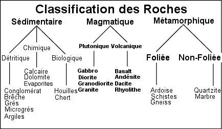 Classification des roches
Ce sont des roches métamorphiques finement feuilletées, de couleur généralement vert clair, composées de quartz, mica, feldspath (albite) et grenat. Elles sont généralement très altérées et donnent des argiles résiduelles qui contribuent à la formation de sols peu perméables.
(Source: Commune de Damgan P.L.U. du 22 mars 2013, page 36 à 38)
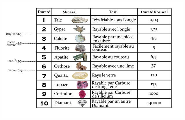 Échelle de Mohs
LES QUESTIONS
Il vous faudra venir muni d'un morceau de verre, ensuite la lecture attentive du descriptif de la cache, ainsi qu'une observation des éléments de terrain et un peu de déduction sont normalement suffisants pour répondre aux questions de cette EarthCache.
- Question 0 : Prenez une photo de vous ou d'un élément vous identifiant avec le Pont Saint-Sauveur en arrière plan.
Cette photo devra au choix nous être transmise avec les réponses ou être ajoutée à votre log.
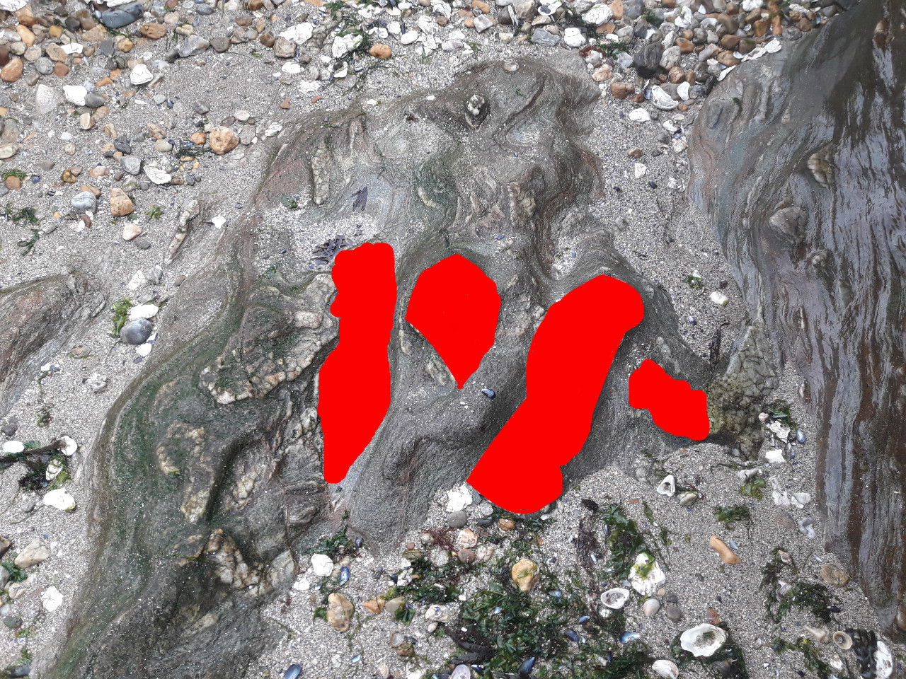
- Question 1 : Trouvez la zone de la photo ci-dessous et décrivez le minéral que vous voyez en inclusion dans le micaschiste sous les zones rouges (couleur, texture, dureté). Essayez de rayer ce minéral avec un morceau de verre, est-ce le verre ou la roche qui se raye? Dès lors, en vous aidant du tableau de l'échelle de Mohs, de quel minéral s'agit-il ?
- Question 2 : Selon vous, en vous aidant du descriptif, et notammant du tableau de classification des roches, quel type de roche a disparu sous le pont au cours de la formation de l'arche?
Vous pouvez vous loguer sans attendre notre confirmation, mais vous devez nous envoyer les réponses en même temps soit par mail via notre profil (Moules de Bouchu), soit via la messagerie geocaching.com (Message Center).
S'il y a des problèmes avec vos réponses nous vous en ferons part. Les logs enregistrés sans réponses et la photo seront supprimés.
Rappel concernant les « Earthcaches »: Il n'y a pas de conteneur à rechercher ni de logbook à renseigner. Il suffit de se rendre sur les lieux, de répondre aux questions ci-dessus et de nous renvoyer les réponses.
!!! BE CAREFUL !!!
THIS EARTHCACHE IS ACCESSIBLE AT LOW TIDE ONLY
To inquire before coming to try to find this cache click here.
KERVOYAL
 Saint-Sauveur’s Bridge
The purpose of this earthcache is to make you discover the Saint-Sauveur’s Bridge which is a natural arch located in the rocks of Kervoyal.
Saint-Sauveur’s Bridge Legend:
This curious natural and rare arch would in fact be the fruit of a divine misunderstanding that took place in the 5th century: A monk, Saint-Sauveur, had come to evangelize Kervoyal, but the local population "who did not believe in these things ... Chased him away with stones. He hid in the rocks of the point and with the help of his stick tapped on the rocks, and suddenly the bridge was formed, he was able to take shelter while the tide rose and left the village saying: “Redon will grow up, Kervoyal will perish! Because he intended to go up the Vilaine.
(Sources: Damganhistoire.fr et Les Amis de Kervoyal)
Natural Arches:
A natural arch or a natural bridge is a geological formation made up of a rock arch, naturally hollowed out by erosion.
The choice of the term "arch" or "bridge" is somewhat arbitrary. The Natural Arch and Bridge Society defines a bridge as a subtype of arch, the formation of which is related to the action of water. In contrast, the Dictionary of Geological Terms defines a natural bridge as a “natural arch that spans a valley due to erosion”.
The formation of natural arches can be the result of 4 types of erosion: marine erosion, erosion by cryoclasty and thermoclasty, erosion by watercourses and cave collapse (although the collapse can also be the consequence of one of the other three types of erosion).
In the case of the Saint-Sauveur’s Bridge , it is a marine arch.
Natural arches by marine erosion:
A sea arch can form in two main ways depending on geological conditions.
When the rock layers composed of alternating hard and soft rocks are perpendicular to the coast, the resulting differential erosion by wave action will release these resistance rocks. This results in promontories whose base is undermined by waves, their energy being concentrated in certain places by a diffraction phenomenon. It can thus create a sea arch which gives rise to a stack once collapsed. The London Arch in Australia is an example of this type of arch.
When these same rock layers are perpendicular to the coast, the waves will pierce through the hard rock layers and erode the soft rocks behind. When the sea arch thus created collapses, it gives rise to a handle.
Formation d'une arche naturelle
Kervoyal’s rocks:
The subsoil of the Morbihan department is entirely contained in a geological entity known as the Massif Armoricain which represents one of the oldest and most complex parts of French territory. This subsoil is made up of various rocks that characterize an ancient mountain range that is now strongly eroded: the Hercynian Range which was formed in the Paleozoic between 450 and 300 million years ago. The type of rock (sedimentary, magmatic, metamorphic) is essentially controlled by a large tectonic accident materialized by very deformed rocks (mylonites) which crosses the territory of Morbihan diagonally: the South Armorican Shear.
The south branch of the shear, oriented North-West / South-East, is the most important and is associated with a secondary fault, oriented East-West, which crosses the subsoil of the municipality of DAMGAN. These geological structures participated in the genesis of the Micaschistes of the Rhuys peninsula, the estuary of the Vilaine and the Pouldu which make up the subsoil of DAMGAN .
Rocks classification
They are finely flaky metamorphic rocks , generally light green in color, composed of quartz , mica , feldspath (albite) and grenat . They are generally very weathered and give residual clays which contribute to the formation of poorly permeable soils.
(Source: Commune de Damgan P.L.U. du 22 mars 2013, page 36 à 38)
Mohs scale
QUESTIONS
You will have to come with a piece of glass, then carefully reading the description of the cache, as well as an observation of the elements of the ground and a little deduction are normally sufficient to answer the questions of this EarthCache.
- Question 0 : Take a photo of yourself or something that identifies you with the Pont Saint-Sauveur in the background.
This photo must either be sent to us with the answers or be added to your log.
- Question 1 : Find the area of the photo below and describe the rock you see as inclusion under the red areas (color, texture, hardness). Try scratching this rock with a piece of glass, is it the glass that is scratching or the rock that is scratching? So, using the Mohs scale chart, what rock is it?
- Question 2 : According to you, using the description, and in particular the rock classification table, what type of rock disappeared under the bridge during the formation of the arch?
You can log this cache without waiting for our confirmation, but you must send us the answers at the same time, by e-mail via our profile (Moules de Bouchu) or by the system of Message Center of geocaching.com.If there is a problem with your answers we will notify you. The logs recorded without answers and the photo will be deleted.
Reminder concerning "Earthcaches": there is neither a container to look for nor a logbook to sign. One need only go to the location, answer to the differents questions and send us the answers.