This geocache is not at the posted coordinates. The Posted Coordinates will take you to the mural, painted in September 2021, that celebrates Landsat's 50th Anniversary. You will gather information at the mural to get the coordinates to the final, which is within walking distance.
The geocache is at:
N 34 38.ABC W 120 27.DEF

The Landsat program is a partnership between NASA and the U.S. Geological Survey (USGS) and for nearly half a century, Landsat has shaped our understanding of Earth. Since the launch of the first Landsat satellite in 1972 from Vandenberg Air Force Base, the mission has gathered and archived more than 9 million images of our home planet’s terrain – providing the longest continuous space-based data record of the Earth’s land surface. The Landsat data record has advanced scientific research and the understanding of our changing planet. A = Two photographs were taken of the Columbia Glacier in Alaska. What is the last digit of the second photograph?
The Landsat user community has driven requirements for improved spatial and radiometric resolution, spectral and temporal coverage, geolocation, and calibration, for each generation of Landsat sensors. B = Which is the oldest active Landsat satellite? (at the time of the mural)
C = Which Landsat satellite launched in 1972?
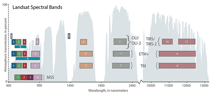
Early Landsat satellites carried a Return Beam Vidicon (RBV) instrument based on proven television-based technology and a newly developed multispectral scanner system (MSS). The MSS was the first space-based instrument to digitally encode Earth data to obtain calibration data in orbit and to measure data in multiple spectral bands. While images can be processed from the MSS’s digital data to conduct qualitative analysis like aerial photos, the ability to analyze satellite data quantitatively was revolutionary and led to the new field of quantitative remote sensing.
The Thematic Mapper (TM) instrument on Landsats 4 and 5 was developed based on the requirements for applications of data – specifically agriculture and geologic exploration – and introduced a 30-meter spatial resolution with seven spectral bands including a thermal infrared band. The Enhanced Thematic Plus (ETM+) that launched on Landsat 7 added increased thermal band resolution and a panchromatic band to enable users to ‘sharpen’ images for increased spatial resolution. D = The number of letters in the African country
The Operational Land Imager (OLI) and Thermal Infrared Sensor (TIRS) instruments on Landsat 8 improved signal-to-noise ratio and radiometric performance enabling 12-bit quantization of data, providing more bits for better Earth surface land characterization. While all Landsat satellites have collected calibration data onboard, Landsat 8 added a lunar calibrator to conduct onboard calibration using the moon like a photographer’s ‘grey card.’ Landsat 9’s instruments, while similar to Landsat 8, offer 14-bit data for even better radiometric resolution. E = Number of letters in the artist's first name
The evolution of Landsat sensors has consistently improved data quality while maintaining precise calibration and backward compatibility within the archive. The data in the Landsat archive from 1972 to the present can be confidently inter-compared, both spatially and radiometrically. In 2008, the free and open Landsat data policy was announced unleashing global-level research without the onus of data cost. Evolving analytical and computing capabilities make it possible to tackle complex world problems in search of a solution. F = The number of letters in the artist's last name.
Today, Landsat data is harmonized with other international and commercial datasets in order to advance our understanding of natural resources, global crop forecasting, forest monitoring, water use, and carbon assessments for future generations. Evolving technology, free data, and robust calibration have helped make Landsat the cornerstone of global land imaging.

You can validate your puzzle solution with certitude.