

 La Reculée
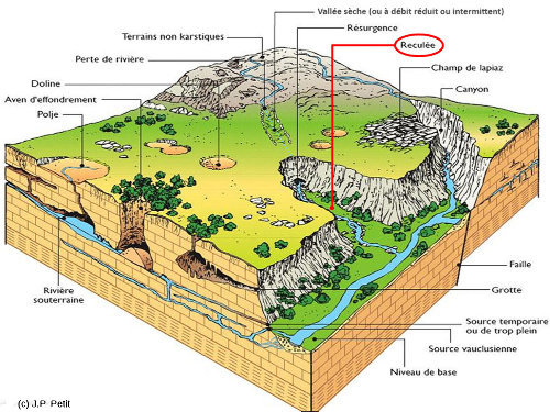
Une reculée est une forme morphologique désignant une échancrure prononcée dans un plateau de couches calcaires tabulaires horizontales constituant un type de vallées fréquentes dans le Jura, en Bourgogne, dans les Causses... La reculée s'achève en amont par un cirque entouré de falaises verticales au pied desquelles prend le plus souvent naissance une rivière, qui est souvent l'exutoire d'un système hydrologique karstique souterrain circulant au travers de cavités interconnectées. Au cours des temps géologiques, le fond de la reculée progresse vers l'amont, en partie à cause du gel et des éboulements des falaises dont les blocs sont emportés par la rivière, et aussi par le recul de la sortie de la rivière souterraine qui s'agrandit et qui finit par s'ébouler. Quand un cours d'eau non souterrain arrive de l'amont en coulant à la surface des couches calcaires, il tombe dans la reculée par une cascade. Mais celle-ci doit avoir un débit faible ou intermittent pour ne pas inciser le rebord de la falaise (la vallée serait alors une vallée ordinaire, et non pas une reculée), ou pour le moins l'inciser plus lentement que son recul dû au gel, aux éboulements et à la sape par la rivière souterraine.
Ce qui donne le schéma classique suivant :
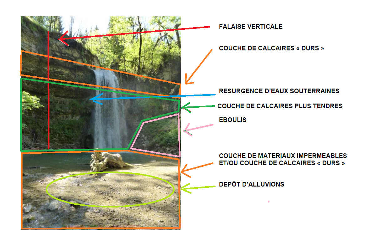
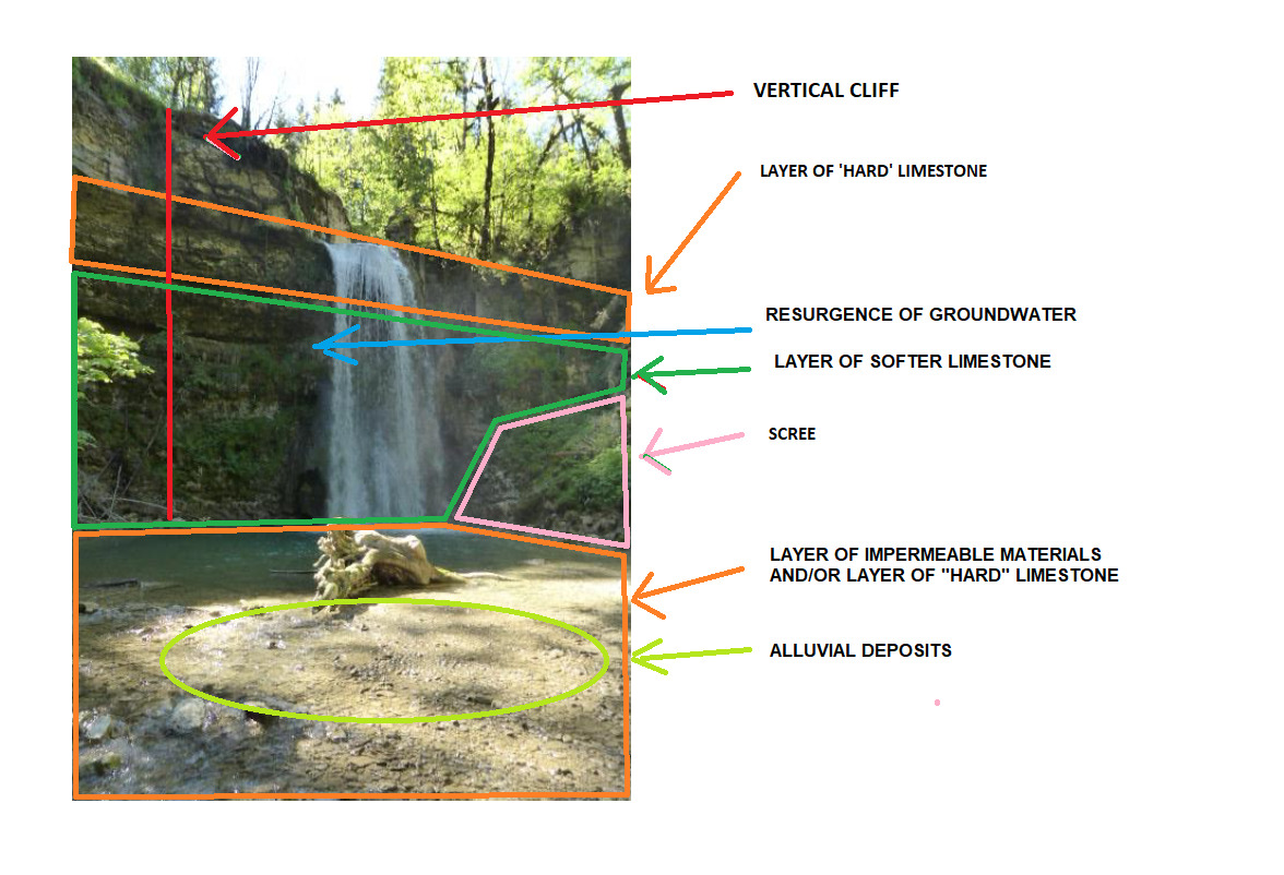
De ce point de vue, le saut de la combe Sandon correspond parfaitement à cette définition :
L'Earthcache

Vu le relief, la précision du GPS pourra être dégradée : fiez-vous à l'image
Pour loguer cette EarthCache, rendez-vous aux coordonnées, et répondez aux questions suivantes.
1 ► Expliquez dans vos propres mots comment se forme une reculée.
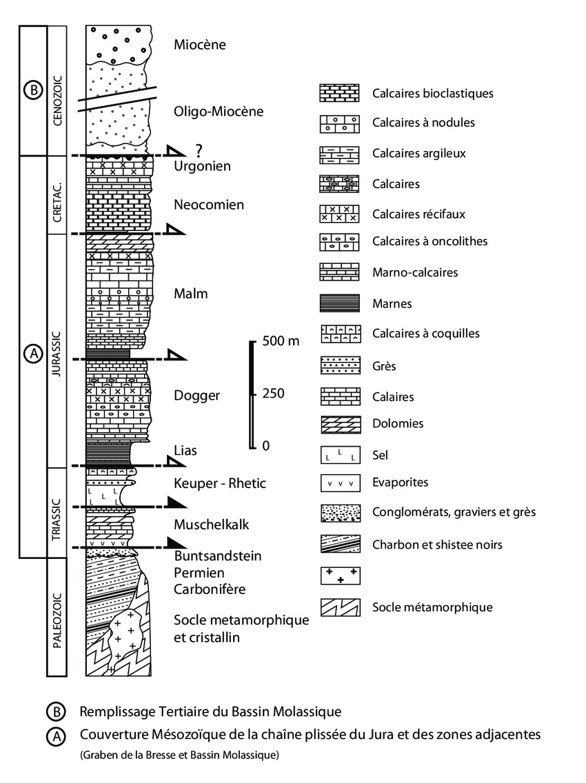
2 ► Que pouvez-vous observer sous le masque jaune ? En vous basant sur l'échelle stratigraphique et en sachant que toutes les roches de la combe datent du Jurassique, à quelle roche avez-vous affaire ? Avez-vous pu en observer ailleurs ?
3 ► Joignez à votre log une photographie permettant ou non de vous identifier (visage, GPS, pseudo, etc.) sur le site... mais sans montrer des éléments qui pourraient compromettre la résolution de la cache. Rien d'obligatoire mais très apprécié : Soyez créatif !
Rappels concernant les « EarthCaches » :
Il n’y a pas de contenant à rechercher aux coordonnées, ni de carnet à signer sur place. Il suffit de se rendre sur les lieux, de répondre aux questions ci-dessus, et de nous envoyer vos propositions de réponse soit via notre profil, soit la messagerie geocaching.com (Message Center).
Vous pouvez loguer un « Found it » sans attendre notre confirmation. Nous vous contacterons en cas de problème ou pour fournir d’éventuelles précisions.
Les « Found it » enregistrés sans envoi de réponses seront supprimés.
Bon Géocaching !
 The Reculée
A reculée is a morphological form designating a pronounced indentation in a plateau of horizontal tabular limestone layers constituting a type of valley frequent in the Jura, in Burgundy, in the Causses... The reculée ends upstream in a cirque surrounded by vertical cliffs, at the foot of which a river usually originates, often as the outlet of an underground karstic hydrological system flowing through interconnected cavities. In the course of geological time, the bottom of the retreat moves upstream, partly due to frost and the collapse of cliffs, whose blocks are carried away by the river, and also due to the retreat of the outlet of the underground river, which expands and eventually collapses. When a non-subterranean river arrives from upstream, flowing over the surface of the limestone layers, it falls into the recule in a waterfall. But the waterfall must have a small or intermittent flow so that it does not cut into the cliff edge (the valley would then be an ordinary valley, not a retreat), or at least cut into it more slowly than it retreats due to frost, landslides and undermining by the underground river.
This results in the following classic scheme:
From this point of view, the Combe Sandon fall corresponds perfectly to this definition:
The Earthcache
To log this EarthCache, go to the coordinates located close to the church, and answer the following questions.
1 ► Explain in your own words how a reculee is formed.
2 ► What can you observe under the yellow mask? Based on the stratigraphic scale and knowing that all the rocks in the combe are Jurassic in age, what rock are you dealing with? Have you seen any elsewhere?
3 ► Join to your log a photo that identifies you (face, GPS, nickname, etc.) on the site... but without showing elements that may compromise the resolution of the cache. Be creative!
Reminders about the “EarthCaches”:
There is no container to look for nor a logbook to sign. Just go to the location, answer the questions above, and send us your proposals of answers either via our profile or Message Center.
You can log “Found it” without waiting for our validation. We will contact you in case of problems or to provide any clarification.
“Found it” logs saved without sending answers will be deleted.
Happy caching!