
Welcome
Welcome to the Little Jerusalem EarthCache Series. This series was placed at the request of the Stae Park so it is important that you follow all rules to demonstrate how responsible geocachers are with the environment. Please stay on the trail and follow all rules as posted. At no point, should you touch, collect, or disturb the environment except where specifically directed. Please enjoy this series of EarthCaches responsibly. There is a $5 day fee to access this park.
Earth Science Lesson
At GZ you will have the "Perfect View" for our geology lesson. You are looking at The Niobrara Formation also called the Niobrara Chalk. It is a geologic formation in North America that was deposited between 87 and 82 million years ago during the Coniacian, Santonian, and Campanian stages of the Late Cretaceous. It is composed of two structural units, the Smoky Hill Chalk Member overlying the Fort Hays Limestone Member. The chalk formed from the accumulation of coccoliths from microorganisms living in what was once the Western Interior Seaway, an inland sea that divided the continent of North America during much of the Cretaceous. It underlies much of the Great Plains of the US and Canada. Evidence of vertebrate life is common throughout the formation and includes specimens of plesiosaurs, mosasaurs, and pterosaurs as well as several primitive aquatic birds.
In front of you you can see this in evidence by noticing the different layers. They are composed of different colors which of course tells us alot about the area. Formerly this area was completely covered in water. Thankfully for us that water is long since gone and has revealed the layers in front of you called strata.
A stratum (plural: strata) is a layer of sedimentary rock or soil, or igneous rock that was formed at the Earth's surface, with internally consistent characteristics that distinguish it from other layers. The "stratum" is the fundamental unit in a stratigraphic column and forms the basis of the study of stratigraphy. A stratum can be seen in almost every single country in the world.
The sediment particles from the largest, or heaviest, settle first, and the smallest, or lightest, settle last. Slight changes in particle size or composition result in the formation of layers, also called beds, in the rock. Layering, or bedding, is the most obvious feature of sedimentary rocks.
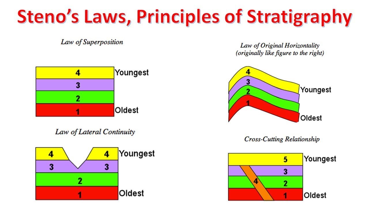
Sedimentary rocks are formed particle by particle and bed by bed, and the layers are piled one on top of the other. Thus, in any sequence of layered rocks, a given bed must be older than any bed on top of it. ThisLaw of Superposition is fundamental to the interpretation of Earth history, because at any one location it indicates the relative ages of rock layers and the fossils in them.
The law of superposition in its plainest form, states that in undeformed stratigraphic sequences, the oldest strata will lie at the bottom of the sequence, while newer material stacks upon the surface to form new deposits over time. This is paramount to stratigraphic dating, which requires a set of assumptions, including that the law of superposition holds true and that an object cannot be older than the materials of which it is composed. Thus older rocks are on the bottom.
Logging Tasks
- Observing what lies in front of you, do the strata run horizontal, vertical, or at an angle?
- Describe the different colors of the layers.
- Based on the information from the previous two questions, which layers are the oldest?
- Do you believe all of these structures formed at roughly the same time? Why?
- Post a photo of yourself, or a proxy, at GZ. (No spoilers please)
References
- Bryant, B.H., Miller, R.D., and Scott, G.R., 1973, Geologic map of the Indian Hills quadrangle, Jefferson County, Colorado: U.S. Geological Survey Geologic Quadrangle Map, GQ-1073, scale 1:24,000
-
Williams, Mark (2020). Mountain Geography. Retrieved from http://snobear.colorado.edu/Markw/Mountains/03/week9.html