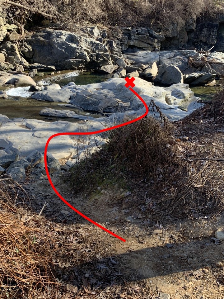
THE LOCATION
In the middle of Four Mile Run, you'll find one of the most spectacular outcrops of rock in all of Northern Virginia. Most of the rocks around the location are loose and out-of-place, but here the solid rock that forms the base of Four Mile Run outcrops at the surface. It is a remarkable rock carved in extraordinary ways by the stream. The endless battle between water and rock is the subject of this Earthcache. To reach GZ, you'll need to go out on the exposed rock to the location marked with a red X. Do not attempt this cache in periods of high water or if ice has built up on the rocks. Permission for this cache was generously granted by Arlington County Parks & Recreation. As with all such caches in county parks, absolutely no night caching is allowed.
IN THE BLUE CORNER: ROCK
The rock at Ground Zero is the Indian Run Formation, which was only recognized as a separate geologic unit in 1985. Formed at the beginning of the Cambrian geologic period about 540 million years ago, these rocks are 1/9th the age of the Earth! At that time, modern North America was part of a supercontinent (Laurentia) that was roughly at the equator. A volcanic arc collided with what is today Eastern North America, forming an enormous mountain range. Geologists call this the Taconic Orogeny. The collison was chaotic, producing rocks that included mud from weathering of the continent, volcanic rocks from the colliding arc, and pieces of all the pre-existing rocks ripped up by the collision. These are the rocks that would become the Indian Run Formation. They were literally only half baked at that point. The rocks were subjected to heat and pressure - metamorphism. The mud was transformed into quartz and feldspar that make up the host of the rock and the vocanic rocks and pre-existing rocks were themselves transformed. Today, the Indian Run Formation contains fragments of these rocks, called olistoliths, ranging from a few centimeters to a few hundred meters in size. The whole rock is called a metamorphosed diamictite.
Like many metamorphic rocks, parts of the Indian Run Formation are well-foliated, meaning it has obvious layering. Many metamorphic rocks also have spectacular folding of those layers. Because the deformation during mountain building happened under heat and pressure, the layers bend and fold, rather than fracturing along faults. Some of these folds are often apparent because the layers have different minerals, resulting in layers of different color. Layers rich in the hard mineral quartz tend to be whiter in color.
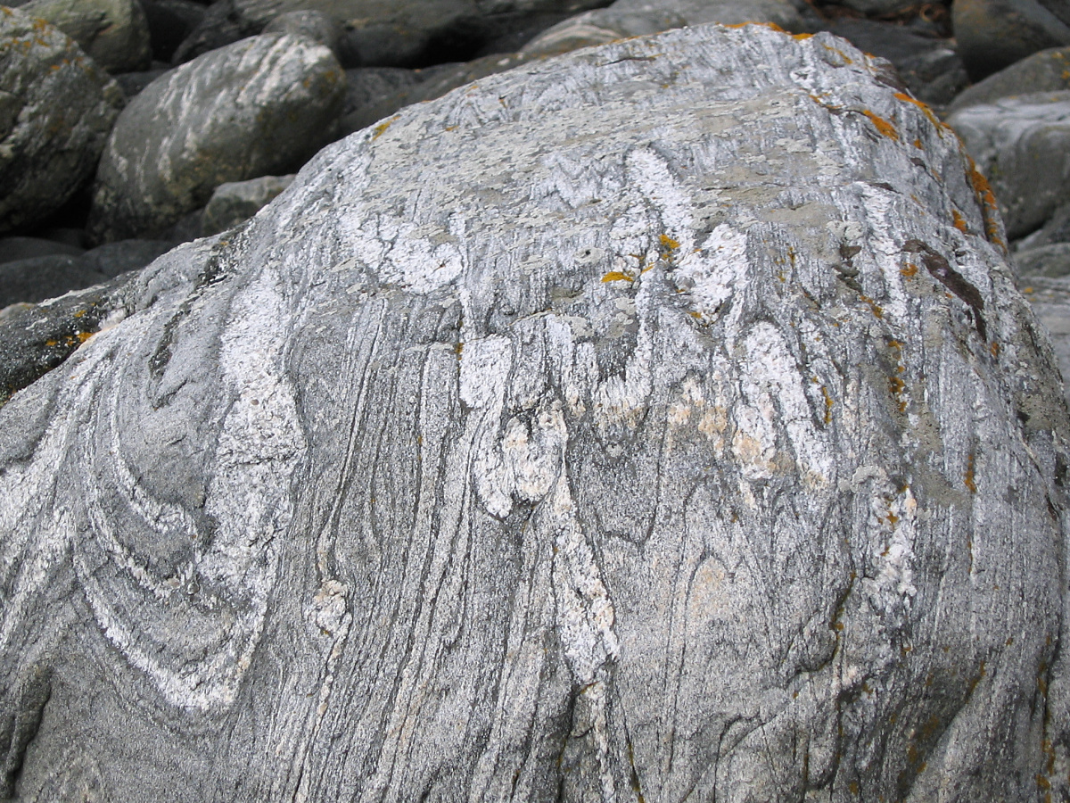
Question 1: Do you see inclusions of rocks that don't look like the rest of the rock (olistoliths)? Do you see any evidence of folding in the rock?
IN THE RED CORNER: WATER
Did you know that every river on Earth runs the same direction? Keep reading and you'll find out where!
Water carves stream valleys. This fact is so engrained in us at such a young age that you've probably never given it a second thought. Surprisingly, it's only partially true! A stream valley is carved by two processes. The first is erosion - the carrying away of rocks or soil from a source. The second is just as important - physical weathering. This is the process by which rocks are broken down into particles that can be carried away during erosion. Let's learn a bit about both.

Particles - rocks, minerals, soil, too often trash - move in streams as either part of the suspended load or the bed load. The suspended load is exactly what it sounds like, with particles suspended in the moving water and never settling out to the bottom while the water is flowing. These particles give many streams their "muddy" appearance. In contrast, particles in the bed load are moving along the bottom of the river, either by sliding or rolling (traction) or by being temporarily lifted off the bottom and essentially bouncing along the bottom (saltation). All of these contribute to erosion, carrying away rocks and soil downstream. Amazingly, most of the erosion, up to 90%, in a stream happens in just a few days a year when the streams are in flood stage.
Question 2: Is the water muddy or can you see the bottom of the stream? Based on these observations, do you think the stream has a high or low suspended load?
What about physical weathering, the breakdown of the rocks into smaller particles? You might think that the suspended load does most of the work as the particles crash into the rock. Maybe the water itself wears away the rock. It might surprise you to know that most of the rock is worn away by the particles in the bed load undergoing saltation. Studies of erosion of hard rocks like you find here show that saltating particles hitting the rocks on the bed of the stream do most of the physical weathering of rocks. Further, the most important factor in how quickly the rocks wear away is the size of the largest particles moving by saltation - the bigger the particle, the more the physical weathering.
Question 3: If the water is clear, pick up a small rock and drop it just upstream of where the water is flowing over the bare outcrop. Did the water carry it over the bare rock? How big a rock can the stream move?
ROCK VS. WATER
Okay, we've learned about the rocks and about the water, but the magic of this site happened when the rock met the water. As you crossed the rocks out to Ground Zero, you passed over where the sediments in the water (see, not just the water!) carved a small channel. Water will take the path of least resistance, so it will always erode the weakest spots first.
Question 4: At this spot, do the rocks show layering and does the water flow with or across the layering? Have all the layers eroded to the same extent? If not, why do you think they did not?
One of the best features at this spot is potholes. Not the potholes you find on the roads, but potholes in solid rock carved by sediment carried in the water (see, not just the water!). These potholes are carved when vertical eddies in a stream begin to form a hole in the bedrock. Rocks are swept into the hole and horizontal eddies move those in a circular pattern, carving out the pothole.

Question 5: Are there rocks in the bottom of the potholes and how big are they? Do you think the stream, flowing at the level it was during your visit, could have moved rocks of this size or did it require higher water levels? Why?
Before you answer the questions below, take a few minutes to enjoy the scenery. Oh yeah: What direction do all streams on Earth flow? Down, of course!
QUESTIONS
Question 1: Do you see inclusions of rocks that don't look like the rest of the rock (olistoliths)? Do you see any evidence of folding in the rock?
Question 2: Is the water muddy or can you see the bottom of the stream? Based on these observations, do you think the stream has a high or low suspended load?
Question 3: If the water is clear, pick up a small rock and drop it just upstream of where the water is flowing over the bare outcrop. Did the water carry it over the bare rock? How big a rock can the stream move?
Question 4: At this spot, do the rocks show layering and does the water flow with or across the layering? Have all the layers eroded to the same extent? If not, why do you think they did not?
Question 5: Are there rocks in the bottom of the potholes and how big are they? Do you think the stream, flowing at the level it was during your visit, could have moved rocks of this size or did it require higher water levels? Why?
WITH YOUR LOG, POST A PHOTO. Posting a photo that readily indicates that you (and anyone else logging the find) were at the location. You do not have to show your face, but the photo should include you or a personal item. Please do not show any answers to any of the questions above. NOTE: Per newly published Earthcache regulations, this is required to claim the find.
If responses to the questions above are not received in a reasonable time period, cachers will receive a request for answers. Failure to respond may result in deletion of your log.
REFERENCES
Simplified Geologic Map of Arlington County (https://gis.arlingtonva.us/Maps/Standard_Maps/Environmental_Maps/Geology.pdf)
A.A. Drake Jr. (1985) Tectonic implications of the Indian Run Formation - A newly recognized sedimentary melange in the Northern Virginia Piedmont. U.S. Geological Survey Professional Paper 1324.
L.S. Sklar and W.E. Dietrich (2006) The role of sediment in controlling steady-stage bedrock channel slope: Implications of the saltation-incision model. Geomorphology 82, 58-83 (A seriously deep dive for the hard core Earthcacher)

Best Earthcache, Most Outstanding Location/Scenery (tie)

Best Earthcache, Most Outstanding Location/Scenery