
La Earthcache / The Earthcache
Le Pic Saint-Loup constitue un monolithe calcaire saillant surgissant subitement dans le paysage.
Quelle histoire géologique a permis la mise en place de cet imposante gardien gardant la porte des contreforts des Cévennes ?
► Formation (-200 à -100 Ma) : Les calcaires jurassiques
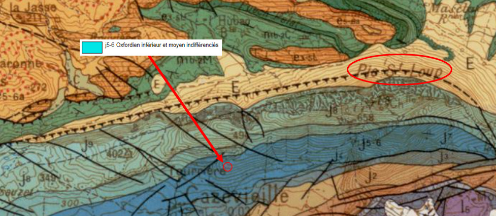
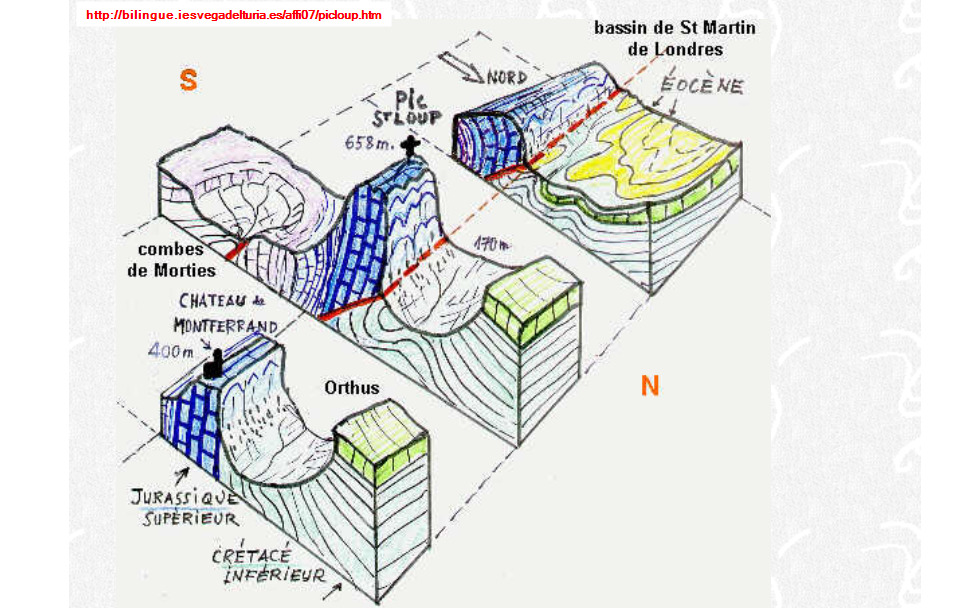
L'étude de la carte géologique montre que le Pic Saint Loup est constitué d'une succession de formations calcaires du jurassique.
Pendant le Jurassique et le Crétacé inférieur, une mer peu profonde recouvre la région.
Durant 100 millions d'années, des sédiments calcaires et marneux vont se déposer au fond d’une grande dépression de terrain appelée par les géologues « Golfe des Causses ».
L'enfouissement de ces formations et leur diagenèse va donner différents types de calcaires en strates sur 2000 mètres d'épaisseur.
Deux faciès calcaires jurassiques constituent la base du Pic Saint Loup :
- j5. Oxfordien moyen (Argovien) : calcaire granuleux, parfois très grossier (en nodules) et riche en fossiles (Ammonites, Radiolaires, Protoglobigérines, Spongiaires,...).
- j6. Oxfordien supérieur (Rauracien) : calcaire gris-bleu, de texture très fine (micritique, grains sub-millimétriques) et pauvre en traces d'organismes (pas de fossile visible).
► Déformation (-40 Ma) : Orogenèse pyrénéenne et anticlinal
Il y a 40 millions d'années, une partie de cette vaste formation jurassique horizontale va être compressée et déformée par des plissements sous la poussée de colossales forces tectoniques à l'origine de l'orogenèse pyrénéenne.
Les compressions se faisant selon un axe Nord-Sud (axe de déplacement des plaques), les déformations vont provoquer des plissements ayant une charnière Ouest-Est.
Certains plissements, dont celui affectant la zone du futur Pic Saint Loup présentent une très grande amplitude, de taille décakilométrique.
La déformation extrême de la zone aboutit à la mise en place d'un véritable arc-boutant, un anticlinal (ensemble de plis convexes formant une bosse).
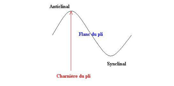
Dans cet anticlinal, les strates à la charnière du pli ont une inclinaison encore subhorizontales, alors celles sur les flancs peuvent être quasiment verticales.
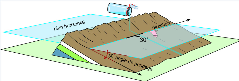
Pour qualifier un pendage d'une couche de roche litée, il faut deux valeurs :
- l'inclinaison des lits par rapport à un plan à l'horizontale, exprimée en degrés.
- la direction du pendage, angle par rapport au Nord du plan horizontal (voir schéma).
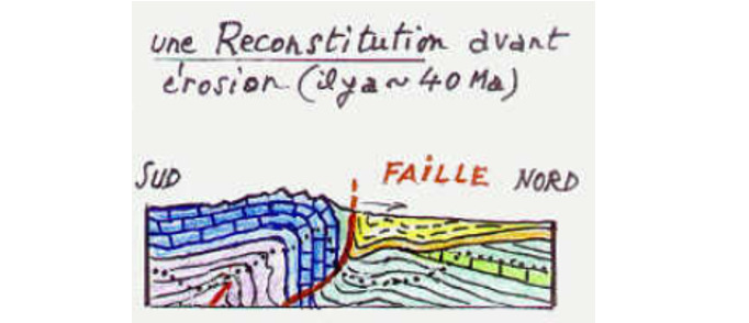
A l'issue de cette orogenèse, un vaste plateau élevé (1000 mètres d'altitude) occupe la région.
Du fait d'un rejeu de failles existantes, le sommet de l'anticlinal de calcaires Jurassiques (au nord) se retrouve au même niveau que des formations marno-calcaires du Crétacé Inférieur (au sud).
► Erosion (-40 Ma à 0 Ma) : Et ainsi naquit le Pic
Depuis 40 millions d'années, l'érosion a attaqué ce haut plateau.
Celui-ci va se transformer petit à petit en un couple d'un pic (le Pic Saint Loup) et d'une combe (la combe de Mortiès), par le jeu de l'érosion différentielle.
En effet, le jeu des failles a mis au contact des types de roches à forts contrastes de dureté ce qui a induit par érosion la mise en relief des calcaires massifs par rapport aux roches plus tendres.
Les calcaires jurassiques massifs et durs formant l'anticlinal sont beaucoup plus résistants que les marnes et schistes sédimentaires du Crétacé Inférieur.
L'érosion accéléré de ces derniers a donc surcreusé la partie sud du plateau, dégageant au fur et à mesure les flancs de l'anticlinal jurassique.
Celui-ci s'est également érodé mais beaucoup plus lentement, entrainant sa mise en relief sous la forme des Pics Saint Loup et du Château de Montferrand.
Pic Saint-Loup is a salient limestone monolith suddenly appearing in the landscape.
What geological history allowed the establishment of this imposing guardian guarding the gate of the Cévennes foothills?
► Formation (-200 to -100 Ma): Jurassic limestones
The study of the geological map shows that the Pic Saint Loup is made up of a succession of limestone formations from the Jurassic period.
During the Jurassic and Lower Cretaceous, a shallow sea covers the area.
For 100 million years, limestone and marl sediments will settle at the bottom of a large depression called by geologists "Gulf of Causses".
The burial of these formations and their diagenesis will give different types of limestone in strata over 2000 meters thick.
Two Jurassic limestone facies form the base of Pic Saint Loup:
- j5. Middle Oxfordian (Argovian): granular limestone, sometimes very coarse (in nodules) and rich in fossils (Ammonites, Radiolaria, Protoglobigerins, Sponges, ...).
- j6. Upper Oxfordian (Rauracian): gray-blue limestone, very fine in texture (micritic, sub-millimeter grains) and poor in traces of organisms (no visible fossils).
► Deformation (-40 Ma): Pyrenean and anticline orogeny
40 million years ago, part of this vast horizontal Jurassic formation was compressed and deformed by folding under the thrust of colossal tectonic forces at the origin of the Pyrenean orogeny.
The compressions being done along a North-South axis (axis of displacement of the plates), the deformations will cause folds having a West-East hinge.
Certain folds, including that affecting the area of the future Pic Saint Loup, have a very large amplitude, of decakilometric size.
The extreme deformation of the area results in the establishment of a real flying buttress, an anticline (set of convex folds forming a bump).
In this anticline, the formations at the hinge of the fold have a still subhorizontal inclination, whereas those on the flanks can be almost vertical.
To qualify a dip of a bedded rock layer, two values are needed:
- the inclination of the beds with respect to a horizontal plane, expressed in degrees.
- the direction of the dip, which is measured 90 degrees from the direction of the layer and defines an angle with respect to North.
At the end of this orogeny, a vast high plateau (1000 meters above sea level) occupies the region.
Due to a replay of existing faults, the top of the Jurassic limestone anticline (to the north) is found at the same level as the marl-limestone formations of the Lower Cretaceous (to the south).
► Erosion (-40 Ma to 0 Ma): And so the Pic was born
For 40 million years, erosion has attacked this high plateau.
This one will gradually transform into a couple of a peak (the Pic Saint Loup) and a valley (the valley of Mortiès), by the play of differential erosion.
Indeed, the play of the faults brought into contact types of rocks with strong contrasts of hardness which induced by erosion the highlighting of massive limestones compared to softer rocks.
The massive and hard Jurassic limestones forming the anticline are much more resistant than the sedimentary marls and schists of the Lower Cretaceous.
The accelerated erosion of the latter therefore deepened the southern part of the plateau, gradually clearing the flanks of the Jurassic anticline.
This one also eroded but much more slowly, causing its relief in the form of the Pics Saint Loup and the Castle of Montferrand.
► Sources bibliographiques / Bibliographical sources
Les Questions / The Questions
Questions pour valider :"Histoire géologique du Pic Saint Loup"
Questions to validate: "Geological history of Pic Saint Loup"
- Question 0 : Prenez une photo de vous ou d'un élément pendant l'ascension du Pic Saint Loup (mais pas au WPs).
Cette photo devra au choix nous être transmise avec les réponses ou être ajoutée à votre log.
-Question 0 : Take a photo of yourself or an item during the ascent of Pic Saint Loup (but not at WPs).
This photo must either be sent to us with the answers or added to your log.
Point 1 : N 43° 46.344 E 003° 47.536
Dans le sens de la montée, regardez les gros affleurements calcaires sur le chemin devant vous.
Going uphill, look at the large limestone outcrops on the path in front of you.
- Question 1 : Décrivez ces affleurements (couleur, texture, présence de fossiles, litage). Déduisez-en le faciès jurassique parmis ceux formant la base du Pic Saint Loup.
- Question 1: Describe these outcrops (color, texture, presence of fossils, bedding). Deduce the Jurassic facies among those forming the base of Pic Saint Loup.
- Question 2 : Essayez de rayer le calcaire avec votre ongle puis avec une pièce de cuivre (si vous avez une). Y arrivez-vous ?
Sachant que les formations marno-calcaires du Crétacé sont rayables à l'ongle, vos observations et déductions sont-elles cohérentes avec la topographie de la région du Pic Saint Loup ? Comment s'appelle le phénomène à l'origine de cette topographie?
- Question 2 :Try scratching the limestone with your fingernail and then with a piece of copper (if you have one). Are you getting there?
Knowing that the marl-limestone formations of the Cretaceous are scratchable with the fingernail, are your observations and deductions consistent with the topography of the Pic Saint Loup region? What is the name of the phenomenon at the origin of this topography?
Point 2 : N 43° 46.378 E 003° 47.583
Depuis le WP2, regardez le chemin dans le sens montant et observez les affleurements rocheux formant ce sentier.
From WP2, watch the path uphill and observe the rocky outcrops forming this path.
- Question 3 : Evaluez le pendage de ces calcaires jurassiques (inclinaison et direction). La direction est-elle cohérent avec le contexte tectonique régional ? Justifiez votre réponse.
- Question 3 : Evaluate the dip of these Jurassic limestones (inclination and direction). Is the direction consistent with the regional tectonic context? Justify your answer.
- Question 4 : De vos observations précédentes, déduisez-en dans quelle zone de l'anticlinal vous vous trouvez.
- Question 4 : From your previous observations, deduce which area of the anticline you are in.
Vous pouvez vous loguer sans attendre notre confirmation,
mais vous devez nous envoyer les réponses en même temps soit par mail via notre profil (
fafahakkai), soit via la messagerie geocaching.com (Message Center).
S'il y a des problèmes avec vos réponses nous vous en ferons part.
Les logs enregistrés sans réponses seront supprimés.
You can log this cache without waiting for our confirmation, but you must send us the answers at the same time, by e-mail via our profile (fafahakkai) or by the system of Message Center of geocaching.com.
If there is a problem with your answers we will notify you. The logs recorded without answers will be deleted.
Rappel concernant les « Earthcaches »: Il n'y a pas de conteneur à rechercher ni de logbook à renseigner. Il suffit de se rendre sur les lieux, de répondre aux questions ci-dessus et de nous renvoyer les réponses.
Reminder concerning "Earthcaches": there is neither a container to look for nor a logbook to sign. One need only go to the location, answer to the differents questions and send us the answers.