
La Earthcache / The Earthcache
La région de Castries est célèbre pour sa Pierre, une roche sédimentaire utilisée dans de nombreux monuments en Hérault.
Partons à la découverte de cette Pierre de Castries dans sa commune d'origine.
► Contexte géologique local
L'étude géologique de la région de Castries montre un ensemble de deux formations sédimentaires principales, un calcaire du Valanginien et un autre du Burdigalien.
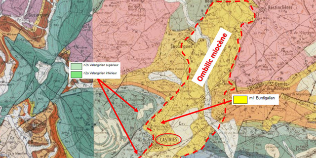
Bien qu'au contact, ces deux formations ont un âge et une nature complètement différents.
► Le calcaire du Valanginien, socle sédimentaire régional
La partie Ouest de Castries est occupée par une calcaire du Valanginien.
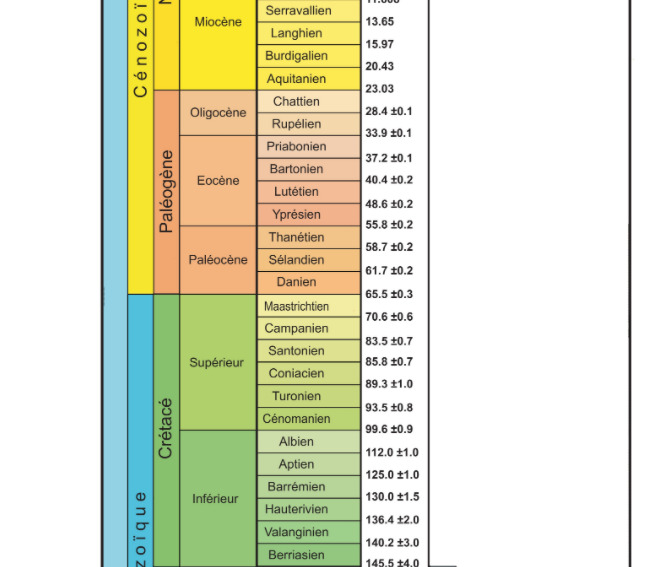
Le Valanginien est le deuxième étage stratigraphique du Crétacé inférieur, rattaché au Mésozoïque.
Cette formation sédimentaire est une biocalcarénite, un calcaire détritique formé de l'accumulation de débris d'organismes vivants.
Ce type de roches se forme notamment dans les zones littorales des régions tropicales dans les massifs dunaires constitués par les sables d'érosion des récifs coralliens.
Les calcarénites sont l'équivalent carbonaté de grès formés par la consolidation de sables calcaires.
Cela donne une formation calcaire microcristalline (taille des grains inférieure au millimètre), compacte, assez brillante, de couleur grisâtres et sans fossile visible à l'œil nu.

► Le calcaire du Burdigalien, la "Pierre de Castries"
La partie Est de Castries est occupée par un calcaire du Burdigalien, la "Pierre de Castries".
~ Formation
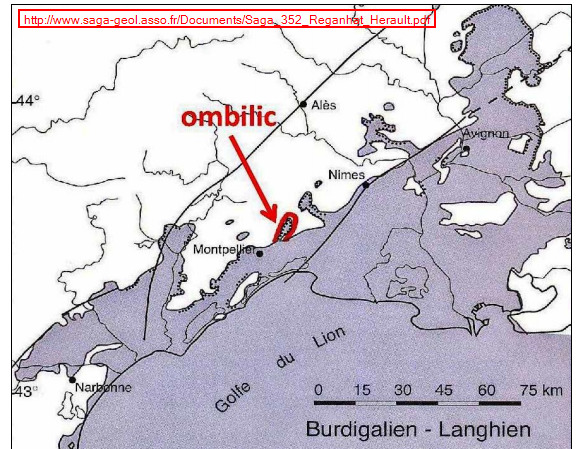
Cette formation s'est mise en place au Burdigalien, 2e subdivision du Miocène rattachée au Cénozoïque.
A cette époque, la région subit un effondrement des formations du Valanginien en lien avec l'ouverture de la Méditerranée occidentale.
Il se produit alors une transgression marine aboutissant à la mise en place d'un ombilic reliant des baies profondes à la paléo-Méditerranée au niveau de la région de Castries.
Cet ombilic se caractérise par des forts courants de marée s'accélérant avant de décroitre dans la baie et de déposer le matériel biogénique.
Il s'y dépose des sables, argiles et surtout des calcaires bioclastiques très riches en coquilles.
~ Caractéristiques
La diagenèse de ces dépôts riches en fossiles a donné un calcaire coquillier très grossier, peu compact, de couleur blanc crème à jaune pâle. Ces débris zoogènes sont peu cimentés, avec de nombreuses alvéoles dans la roche.
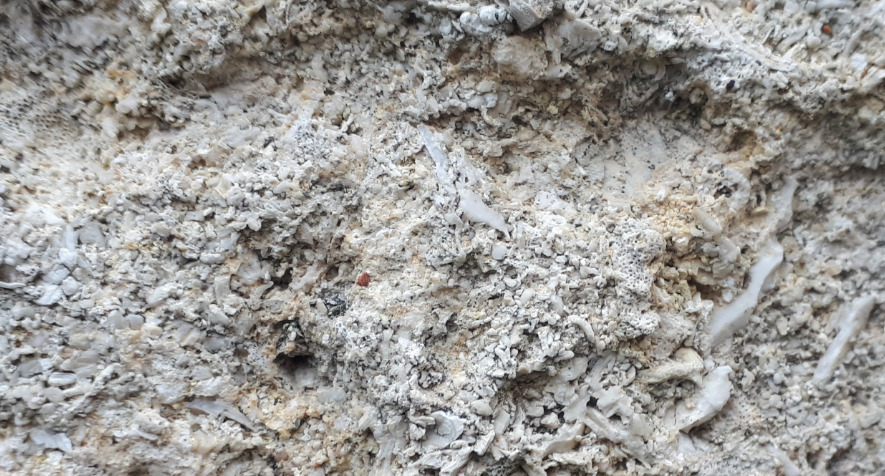
La roche est tendre mais résistante à l'érosion et à la charge (11 kg par cm2), ce qui en fait une pierre de taille facile à travailler et de qualité.
C'est une roche très riche en fossiles, dont voici quelques exemples :

► Continuité et lacune stratigraphique
Dans le cadre de formations sédimentaires, il y a un principe de continuité : deux formations au contact doivent normalement se suivre en terme d'âge géologique absolue.
Lorsqu'il n'y a pas de continuité chronologique entre deux couches, ces formations sont discordantes, séparées par une lacune.
Pour caractériser la présence d'une lacune entre deux formations géologiques, il faut considérer leur âge absolue selon l'échelle des temps géologiques.
The region of Castries is famous for its Pierre, a sedimentary rock used in many monuments in Hérault.
Let's go and discover this Pierre de Castries in its town of origin.
► Local geological context
The geological study of the Castries region shows a set of two main sedimentary formations, one limestone from the Valanginian and another from the Burdigalian.
Although in contact, these two formations have a completely different age and nature.
► Valanginian limestone, regional sedimentary base
The western part of Castries is occupied by Valanginian limestone.
The Valanginian is the second stratigraphic stage of the Lower Cretaceous, attached to the Mesozoic.
This sedimentary formation is a biocalcarenite, a detrital limestone formed from the accumulation of debris from living organisms.
This type of rock is formed in particular in coastal areas of tropical regions in dune massifs formed by the erosion sands of coral reefs.
Calcarenites are the carbonate equivalent of sandstone formed by the consolidation of limestone sands.
This gives a microcrystalline limestone formation (grain size less than a millimeter), compact, fairly shiny, grayish in color and without fossils visible to the naked eye.
► Burdigalian limestone, the "Pierre de Castries"
The eastern part of Castries is occupied by a Burdigalian limestone, the "Pierre de Castries".
~ Formation
This formation was set up in the Burdigalien, 2nd Miocene subdivision attached to the Cenozoic.
At that time, the region suffered a collapse of the Valanginian formations in connection with the opening of the western Mediterranean.
A marine transgression then occurs leading to the establishment of an umbilicus connecting deep bays to the paleo-Mediterranean at the level of the region of Castria.
This umbilicus is characterized by strong tidal currents accelerating before decreasing in the bay and depositing the biogenic material.
Sands, clays and especially bioclastic limestones very rich in shells are deposited there.
~ Features
The diagenesis of these fossil-rich deposits gave a very coarse, not very compact shell limestone, creamy white to pale yellow in color. These zoogenic debris are not very cemented, with many cells in the rock.
The rock is soft but resistant to erosion and load (11 kg per cm2), which makes it an easy to work and quality cut stone.
It is a rock very rich in fossils, here are some examples:
► Continuity and stratigraphic gap
In the context of sedimentary formations, there is a principle of continuity: two formations in contact must normally follow each other in terms of absolute geological age.
When there is no chronological continuity between two layers, these formations are discordant, separated by a gap.
To characterize the presence of a gap between two geological formations, it is necessary to consider their absolute age according to the geological time scale.
► Sources bibliographiques / Bibliographical sources
Les Questions / The Questions
Questions pour valider :"La Pierre de Castries"
Questions to validate: "The Stone of Castries"
- Question 0 : Prenez une photo de vous ou d'un élément vous identifiant avec l'Aqueduc de Castries en arrière plan (mais pas au WPs).
Cette photo devra au choix nous être transmise avec les réponses ou être ajoutée à votre log.
-Question 0 : Take a picture of yourself or of an element that identifies you with the Castries Aqueduct in the background (but not at the WPs).
This photo must either be sent to us with the answers or added to your log.
Point 1 : N 43° 40.707 E 003° 59.171
Vous voici au pied de l'aqueduc, dos à l'église (photo WP1).
Here you are at the foot of the aqueduct, with your back to the church (photo WP1).
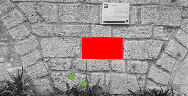
- Question 1 : Décrivez le bloc de roche sous la zone rouge rectangle. De quelle formation de la région de Castries s'agit-il ?
- Question 1: Outline the block of rock under the red rectangle area. What formation in the region of Castria is it?
- Question 2 : Identifiez les fossiles que vous voyez sous les deux zones vertes rondes.
- Question 2 : Identify the fossils you see under the two round green areas.
Point 2 : N 43° 40.738 E 003° 59.157
Vous voici devant l'endroit ou l'aqueduc fait un angle pour changer de direction. Observons la base du pilier de ce changement de direction où affleure la roche mère servant de soubassement.
Here you are in front of the place where the aqueduct makes an angle to change direction. Let us observe the base of the pillar of this change of direction where the mother rock is exposed, serving as a base.

- Question 3 : Décrivez la roche sous la zone bleue. Le soubassement de l'Aqueduc est-il fait de Pierre de Castries ? Si non de quelle formation s'agit-il ?
- Question 3 : Outline the rock below the blue area. Is the base of the Aqueduct made of Pierre de Castries? If not, what training is it?
- Question 4 : Déterminez la différence d'âge absolue des deux formations au contact de la région de Castries. Est-ce cohérent d'un point de vue stratigraphique ? Comment s'appelle ce phénomène ?
- Question 4 : Determine the absolute age difference of the two formations in contact with the Castries region. Is it stratigraphically consistent? What is this phenomenon called?
Vous pouvez vous loguer sans attendre notre confirmation,
mais vous devez nous envoyer les réponses en même temps soit par mail via notre profil (
fafahakkai), soit via la messagerie geocaching.com (Message Center).
S'il y a des problèmes avec vos réponses nous vous en ferons part.
Les logs enregistrés sans réponses seront supprimés.
You can log this cache without waiting for our confirmation, but you must send us the answers at the same time, by e-mail via our profile (fafahakkai) or by the system of Message Center of geocaching.com.
If there is a problem with your answers we will notify you. The logs recorded without answers will be deleted.
Rappel concernant les « Earthcaches »: Il n'y a pas de conteneur à rechercher ni de logbook à renseigner. Il suffit de se rendre sur les lieux, de répondre aux questions ci-dessus et de nous renvoyer les réponses.
Reminder concerning "Earthcaches": there is neither a container to look for nor a logbook to sign. One need only go to the location, answer to the differents questions and send us the answers.