LE TUFFEAU DANS TOUS SES ETATS : BALADE AU GRAND-LUCE
Le Tuffeau, le Tuffeau et encore le Tuffeau !
A croire qu’il n’y a que cette roche pour certains géocacheurs…
Je sais, il est vrai que nous le rencontrons souvent ce fameux tuffeau mais que voulez-vous ? Il existe des endroits typiques où cette roche fait partie intégrante du patrimoine et ici, au Grand-Lucé, c’est encore plus vrai.
Le tuffeau
Le tuffeau blanc est un calcaire crayeux. Sa teneur en carbonate de calcium varie de 40 à 80 %. La partie carbonatée est complexe ; elle est constituée de microparticules calcaires et de cristaux de calcite. La partie non carbonatée (30 à 60 %) est composé d’argiles, de paillettes de mica blanc (silicate), de grains de quartz (silice), de grains de glauconie (argiles), et d’éléments microscopiques : opale-CT sous forme de petites sphères (pour l’organisation et l’origine des composants microscopiques).
L’abondance des vides, remplis d’eau dans la roche en place, explique la friabilité et la fragilité du matériau, mais aussi la facilité de sa taille.
Le sédiment s’est déposé en milieu marin sur la plate-forme continentale de la « Mer de la Craie » vers une profondeur de 50 à 100 m.
Les composants du tuffeau ont une origine soit chimique, soit détritique. Quartz et mica proviennent de l’érosion de roches silicatées des terres du Massif armoricain ou du Massif central proches, ou de roches déposées antérieurement dans la région comme les Sables et grès de Vierzon (Cénomanien).
Le Grand-Lucé
La page wikipédia concernant cette commune est assez complète et je vous invite à la découvrir ici.
Retenons cependant un élément de son histoire pour le moins important pour cette Earthcache.
L’incendie de 1781 a fait brûler 144 maisons, une partie du presbytère et de l’église de Lucé. Une quête générale fut organisée dans le diocèse du Mans. Lucé est rebâtie en dix ans, autour de l’actuelle place de la République, avec de la pierre calcaire de tuffeau extraite du sol de la ville. Les ardoises pour les toits arrivent par la rivière du Loir, à Port-Gautier. Au sud de la ville, le château a été construit à partir de 1761 par l’ingénieur Mathieu de Bayeux pour Jacques III Pineau de Viennay, qui était intendant du roi et baron de Lucé. Il a récemment été transformé en hôtel de luxe.
Vous avez bien lu ?
Le Tuffeau utilisé pour rebâtir en grande partie cette ville a été extrait du sol de la ville !
Et si nous creusions un peu plus ce sujet ?
CONTEXTE GEOLOGIQUE
La commune du Grand-Lucé se situe sur le plateau compris entre Le Mans et la vallée de la Braye, qui est constitué de terrains appartenant aux assises crétacées. Ces terrains constituent la bordure occidentale du bassin Parisien. Plus à l’ouest, vers Ecommoy, on trouve les formations plus anciennes du Jurassique. Enfin, la limite est du massif Armoricain déborde légèrement sur le département de la Sarthe, avec l'extrémité des Coëvrons (vers Sillé-le-Guillaume).

1/ Substratum
Autour du Grand-Lucé, les formations géologiques du substratum ont une structure tabulaire, c’est à-dire qu’elles sont sub-horizontales (très faible pendage de 1 à 2 degrés vers l’est). Celles-ci sont décrites ci-dessous, de la plus récente à la plus ancienne.
On rencontre tout d’abord des matériaux argileux, formant les terrains d’assises du centre du Grand-Lucé. Cette zone argilo-sableuse, d’épaisseur variable, est très sensible aux variations hydriques (phénomène de retrait / gonflement). Progressivement, on passe ensuite à des argiles à silex provenant de la décalcification de la craie turonienne sous-jacente. De couleur fauve à brune (présence d’oxydes de fer), ces argiles sont plutôt sableuses dans la région du Mans et renferment de très nombreux silex très durs. A la surface de ces argiles, on trouve parfois des brèches crayeuses silicifiées extrêmement dures, sous forme de rognons et de blocs.
Sous ces argiles, on trouve une craie sableuse du Turonien, de couleur blanchâtre à beige, comprenant des concrétions calcaréo-crayeuses. En effet, on rencontre au sein de cette craie des parties plutôt gréseuses, qui passent latéralement à un tuffeau plus ou moins lité et altéré. Ce sont ces bancs de craie tuffeau indurée qui ont été exploités dans les galeries souterraines du Grand-Lucé. A sa base, cette craie devient marneuse et à silex noirs. L’ensemble de cette formation crayeuse peut atteindre 40 à 60 m d’épaisseur.
Enfin, on rencontre les sables du Cénomanien : de couleur fauve à grisâtre, ils comprennent localement des lentilles de grès grossiers et des veines d’argile grise, verdâtre, bleuâtre ou rouille. Ces sables peuvent atteindre une épaisseur de 70 à 120 m et reposent, dans le secteur du Mans, en discordance sur les formations sous-jacentes du Jurassique (terrains oxfordiens).
2/ Formations quaternaires
Les formations quaternaires sont présentes en fond de vallée et sur les plateaux, et masquent les formations du substratum. Ainsi, on distingue :
Les alluvions modernes : de 2 à 3 m d’épaisseur, elles peuvent être sableuses ou tourbeuses et ne sont présentes qu’en fond de vallée ;
Les limons de plateau : ils forment une couverture limoneuse à sableuse par endroit, recouvrant le sommet des plateaux. Leur épaisseur est très variable.
Exploitation du sous-sol
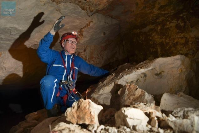
Le sous-sol de la commune de Grand-Lucé a donc autrefois fait l'objet d'exploitation, notamment pour la pierre de taille. Le village, et en particulier le centre-bourg, est construit sur un véritable "gruyère" d'anciennes carrières souterraines de tuffeau, datant pour les plus vieilles du XVIIème siècle. De ces galeries souterraines ont été extraits des blocs de tuffeau qui ont servi à la reconstruction du château et des bâtiments du Grand-Lucé, qui avaient été ravagés par un incendie en 1781. Cette craie tuffeau a été également utilisée pour contrecarrer l'acidité naturelle des sols par amendements : la craie tuffeau était extraite de marnières et incorporée dans les terres agricoles pour les rendre plus fertiles. Ces galeries souterraines ont été exploitées jusqu'au début du XXème siècle, puis ont été abandonnées. Certaines ont ensuite été utilisées comme champignonnières (vers le hameau de Miaules), mais ne sont plus exploitées.
Une visite de ces carrières ? Cliquez sur cette image.
Passionnante cette descente dans ces galeries, non ? Retenez bien l’image du début de cette vidéo, je vous emmène prochainement à la découverte de ce puits.
Mais pour l’heure, il nous faut revenir à nos moutons ou plutôt à ce Tuffeau.
Ici, c’est à la découverte de ses altérations et des conséquences liées à ces altérations et aux propriétés physiques du Tuffeau que je vous dirige alors quelles sont-elles et qu’est-ce que ça engendre au niveau des galeries souterraines ?
Ses altérations
Le tuffeau est une pierre tendre, fragile, poreuse. Il s’altère rapidement dès que les conditions sont défavorables. Les facteurs de dégradations sont nombreux :
Les facteurs internes de la pierre
Dans les bancs de tuffeau, on retrouve des silex communément appelés « chenards » et des éléments ferreux. Ces fragments peuvent provoquer une perte de cohésion dans la pierre. Les faces d’une même pierre présentent des différences de températures importantes selon leurs expositions en façade. Ces chocs thermiques finissent par fracturer la pierre de tuffeau notamment en chaîne d’angle. Le lit de la pierre doit aussi être marqué par un trait à la sortie de carrière. Si le maçon pose le tuffeau en délit, sa résistance à la compression est mauvaise et la pierre se fragmente.
Les dégradations liées à l’eau
L’eau transporte un bon nombre d’agents chimiques, appelés sels solubles, pouvant réagir avec le tuffeau. Quand l’eau s’évapore du mur, les sels solubles se cristallisent vers la surface de la pierre. L’action répétée des sels provoque des desquamations* ou des alvéoles. Lorsqu’il est saturé en eau, le tuffeau perd 30 % de sa résistance à la compression. Soumise à des charges importantes, la pierre trempée se fracture. Enfin, en hiver, la pierre peut éclater par la répétition des cycles gel/dégel.
Les incompatibilités avec les autres matériaux
Le ciment : l’incompatibilité avec le ciment est rédhibitoire. Utilisé comme enduit, le ciment empêche le tuffeau de « respirer » et favorise l’éclatement de la pierre lors des jours de gel. Utilisé comme joint, il stoppe les circulations d’eau dans les pierres voisines.
Les autres pierres : lorsque le tuffeau est en contact avec une pierre plus dure, la roche la plus tendre se dégrade plus rapidement à cause de la rétention d’eau. C’est pourquoi au XIXe siècle, on retrouve une brique entre le tuffeau et les pierres froides du soubassement. La perméabilité de la brique favorise l’évaporation de l’eau et évite la stagnation de l’humidité dans le tuffeau.
L’action des organismes vivants
En milieu rural, les surfaces exposées aux pluies, au rejaillissement ou au ruissellement présentent des teintes variées dues à divers types d’algues ou de champignons. Sur les rondelis (ornements de forme ronde), les éléments saillants et les façades ouest, on retrouve principalement des salissures noires. En retenant l’humidité, ces lichens favorisent les dégradations liées à l’eau.
Les risques naturels liés aux carrières souterraines
La commune de Grand-Lucé est essentiellement concernée par le phénomène d'affaissement et d'effondrement des anciennes cavités souterraines.
Les affaissements et les effondrements sont consécutifs à l'évolution de cavités souterraines naturelles ou anthropiques. Au Grand-Lucé, il s'agit de cavités anthropiques : carrières, marnières, mines ou champignonnières, désormais abandonnées.
Lors d'un affaissement, la rupture du toit d'une cavité souterraine est progressive et amortie, de sorte qu'en surface, aucune rupture du sol n'est visible. Une dépression topographique en forme de cuvette apparaît alors, due au fléchissement des terrains.
Les effondrements sont des phénomènes plus rapides et brutaux. La rupture se propage jusqu'à la surface, provoquant l'ouverture d'une excavation ou fontis, dont le diamètre varie de quelques mètres à quelques dizaines de mètres, et qui peut s'élargir par éboulements successifs. Dans certains cas, les affaissements peuvent évoluer en effondrements.
Concernant les galeries souterraines du Grand-Lucé, il existe principalement deux modes de rupture :
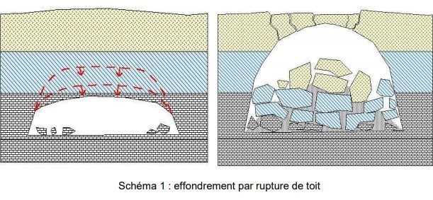
- La rupture de toit ou fontis : Au début se produit la chute d'un banc de tuffeau qui se détache du ciel de la galerie. Puis, suivent successivement plusieurs autres bancs. La cavité ainsi créée est appelée cloche de fontis. Elle peut soit remonter jusqu'à la surface, soit se résorber.

- La rupture de piliers : Les fortes contraintes de compression exercées sur les piliers provoquent un phénomène d'écaillage : ils se fracturent, s'écaillent, et parfois se rompent. Les piliers voisins peuvent s'effondrer à leur tour, ce qui provoque un effondrement généralisé en surface.

Les facteurs aggravants
De nombreux facteurs peuvent conduire à la dégradation des cavités souterraines. Ils peuvent être de deux types : naturels ou anthropiques.
Facteurs naturels :
La fragilisation liée à la nature de la roche : La craie tuffeau est une roche relativement friable, qui se dégrade naturellement avec le temps. De plus, elle est par endroits très fracturée (fissures de décompression, failles remplies d'argiles, diaclases), ce qui permet une dislocation de la masse rocheuse. Par ailleurs, les piliers des galeries supportent des contraintes verticales entraînant un phénomène d'écaillage et de fluage des matériaux. Ces processus fragilisent considérablement les piliers.
Les infiltrations d'eau et l'hydrogéologie : Les infiltrations et les circulations d'eau contribuent largement à la dégradation de la craie tuffeau. En effet, l'eau s'infiltre dans les fractures, exerce une pression hydrostatique, dissout la craie et augmente le poids des roches. Ainsi, une période de forte pluviométrie peut être un facteur de déclenchement ou d'accélération du phénomène d'affaissement-effondrement, notamment par l'élévation du niveau des nappes d'eau souterraines.
Facteurs anthropiques :
Les conditions et les modes d'exploitation : Les carriers qui exploitaient ces galeries souterraines ne s'inquiétaient pas forcément à l'époque de la stabilité à long terme des cavités. Ils suivaient les fractures remplies d'argile pour extraire plus facilement les blocs de tuffeau, malgré le fait que cela déstabilisait les cavités. De plus, les galeries étaient agencées de manière assez aléatoire, et les portées entre piliers étaient parfois bien trop grandes.
Le manque d'aération : Au terme de leur exploitation, les puits d'accès aux galeries et aux marnières étaient abandonnés et rebouchés avec un mélange de branchages, de terre et de gravats. Cela a eu pour conséquence une augmentation de l'humidité ambiante dans les galeries par manque d'aération, et donc une altération plus rapide des parois de craie tuffeau rendues très friables.
Les vibrations et les surcharges pondérales : La surcharge pondérale engendrée par les constructions, mais aussi les vibrations provoquées par le passage de véhicules lourds (camions, bus, engins de travaux…), sont des facteurs aggravant l'instabilité des cavités.
Les fuites de réseaux d'eau : Une infiltration importante et continue d'eau par rupture d'une canalisation est un facteur d'accélération du phénomène d'affaissement-effondrement.
L’Earthcache et ses questions
Ca y est enfin ! Voilà ces questions auxquelles il vous faudra répondre pour valider votre trouvaille. Une lecture du descriptif, un peu de recherche sur la Toile et surtout de l’observation devraient vous permettre de répondre tranquillement. Parfois, plusieurs réponses seront possibles.
Vous pourrez loguer un Found-it sans attendre mais vous aurez à m’envoyer vos réponses via ma messagerie géocaching. Tout log sans réponse sera bien évidemment supprimé.
C’est parti !
Question 1 :
Selon vous et selon l’échelle stratigraphique, de quel étage, époque, période, ère et éon date le Tuffeau du Grand Lucé ?
Question 2 et 2 bis:
Quelle est la porosité du Tuffeau exprimée en pourcentage ?
Quelle est sa résistance à la compression exprimée en N/mm2 ?
Question 3 :
Il va vous être demandé de visiter plusieurs endroits situés non loin les uns des autres, rassurez-vous. Pour chacun d’eux et grâce au descriptif et à vos connaissances sur le sujet, je vous invite à décrire ce que vous voyez et à me dire quel(s) type(s) d’altération(s) vous pouvez observer sur place.
WP 1 : N 47° 51.877 E 000° 28.179
Vous êtes à l’une des entrées du château.
Rque : Regardez bien les murs de tuffeau à gauche et à droite de cette entrée.
WP 2 : N 47° 51.903 E 000° 28.206
Vous êtes à l’angle de la rue de la libération et du square St Facile.
Observez bien l’angle de ce mur de haut en bas.
WP 3 : N 47° 51.913 E 000° 28.136
Vous êtes sur la place du château et devant une fenêtre condamnée. Observez bien le mur à sa proximité.
WP 4 : N 47° 51.921 E 000° 28.163
Vous êtes face au 1 rue St Facile. Regardez bien ce qui se passe à son angle gauche.
Question 4
Après avoir visité tous les WP, où avez-vous vu la présence de chenards ?
Question 5
Rendez vous au WP : N 47°51.915 E 000°28.193
Vous êtes devant l’un des anciens puits d’accès aux galeries souterraines (rappelez-vous le départ de la vidéo proposée auparavant), celui de la carrière de la ruelle des Derrières
Les spéléologues ont topographié un développement de 66 m de galeries. Cette carrière est très instable. En effet, le tuffeau est très fracturé, les piliers s'écaillent et de nombreux blocs se sont déjà décrochés. Entre 1968 et 1987 de nombreux effondrements ont eu lieu.

Vous n’aurez pas vraiment à répondre à une question (je ne vous demanderai pas de descendre dans le puits même si je sais que ça plairait à certains), mais plutôt à prendre une photo de vous ou de l’un des objets vous caractérisant devant ce puits pour preuve de passage.

English Version
Tuffeau, Tuffeau and again Tuffeau!
To believe that there is only this rock for some geocachers ...
I know, it is true that we often meet this famous tuffeau but what do you want? There are typical places where this rock is an integral part of the heritage and here, in Grand-Lucé, it is even more true.
TUFFEAU
White tuffeau is a chalky limestone. Its calcium carbonate content varies from 40 to 80%. The carbonate part is complex; it consists of calcareous microparticles and calcite crystals. The non-carbonated part (30 to 60%) is composed of clays, flakes of white mica (silicate), grains of quartz (silica), grains of glauconia (clays), and microscopic elements: opal-CT in the form of small spheres (for the organization and origin of microscopic components).
The abundance of voids, filled with water in the bedrock, explains the friability and fragility of the material, but also the ease of its size.
The sediment was deposited in the marine environment on the continental shelf of the "Chalk Sea" to a depth of 50 to 100 m.
The components of tuffeau have either a chemical or detrital origin. Quartz and mica come from the erosion of silicate rocks from the lands of the Armorican Massif or the nearby Massif Central, or from rocks previously deposited in the region such as the Sables et sandstone of Vierzon (Cenomanian).
THE GRAND-LUCE
The Wikipedia page for this town is quite complete and I invite you to discover it here.
Let us however retain an element of its history for the less important for this Earthcache.
The fire of 1781 burned down 144 houses, part of the presbytery and the Lucé church. A general collection was organized in the diocese of Le Mans. Lucé was rebuilt in ten years, around the current Place de la République, with limestone tufa extracted from the soil of the city. The slates for the roofs arrive by the Loir river, in Port-Gautier. To the south of the city, the castle was built from 1761 by the engineer Mathieu de Bayeux for Jacques III Pineau de Viennay, who was intendant to the king and baron de Lucé. It has recently been transformed into a luxury hotel.
You read correctly?
The Tuffeau used to rebuild much of this city has been extracted from the soil of the city!
What if we dig a little deeper into this topic?
GEOLOGICAL CONTEXT
The town of Grand-Lucé is located on the plateau between Le Mans and the Braye valley, which consists of land belonging to the Cretaceous foundations. These lands constitute the western edge of the Paris basin. Further west, towards Ecommoy, we find the older Jurassic formations. Finally, the eastern limit of the Armorican massif overflows slightly on the department of Sarthe, with the end of Coëvrons (towards Sillé-le-Guillaume)

1 / Substratum
Around Grand-Lucé, the geological formations of the substratum have a tabular structure, that is to say, they are sub-horizontal (very slight dip of 1 to 2 degrees to the east). These are described below, from the most recent to the oldest.
We first encounter clayey materials, forming the foundations of the center of Grand-Lucé. This clayey-sandy zone, of variable thickness, is very sensitive to water variations (shrinkage / swelling phenomenon). Gradually, we then move on to flint clays from the decalcification of the underlying Turonian chalk. Fawn to brown in color (presence of iron oxides), these clays are rather sandy in the region of Le Mans and contain a large number of very hard flints. On the surface of these clays, we sometimes find extremely hard silicified chalky breccias, in the form of kidneys and blocks.
Under these clays, there is a sandy chalk of the Turonian, whitish to beige in color, comprising calcareous-chalky concretions. Indeed, within this chalk, we find rather sandstone parts, which laterally pass to a more or less bedded and weathered tufa. It is these benches of indurated tufa chalk that were exploited in the underground galleries of Grand-Lucé. At its base, this chalk becomes marly and with black flints. The whole of this chalky formation can reach 40 to 60 m in thickness.
Finally, we encounter the Cenomanian sands: fawn to greyish in color, they locally include coarse sandstone lenses and gray, greenish, bluish or rusty clay veins. These sands can reach a thickness of 70 to 120 m and rest, in the sector of Le Mans, in discordance on the underlying formations of the Jurassic (Oxfordian grounds).
2 / Quaternary Training
Quaternary formations are present at the bottom of the valley and on the plateaus, and mask the formations of the substratum. Thus, we distinguish:
Modern alluvium: 2 to 3 m thick, they can be sandy or peaty and are only present at the bottom of the valley;
Plateau silts: they form a silty to sandy cover in places, covering the top of the plateaus. Their thickness is very variable.
Operation of the basement
The basement of the town of Grand-Lucé was therefore formerly the object of exploitation, in particular for freestone. The village, and in particular the town center, is built on a real "Gruyère" from old underground tufa quarries, dating for the oldest from the 17th century. From these underground galleries were extracted blocks of tuffeau which were used for the reconstruction of the castle and the buildings of Grand-Lucé, which had been devastated by a fire in 1781. This chalk was also used to counteract the natural acidity Soils by amendments: tuffeau chalk was extracted from marl fields and incorporated into agricultural land to make them more fertile. These underground galleries were exploited until the beginning of the 20th century, then were abandoned. Some were then used as mushroom beds (towards the hamlet of Miaules), but are no longer exploited.
A visit to these quarries? Click on this picture.

Exciting this descent in these galleries, not? Remember the image at the beginning of this video, I will soon take you to explore this well.
But for now, we have to get back to our sheep, or rather this Tuffeau.
Here, it is to discover its alterations and the consequences linked to these alterations and to the physical properties of Tuffeau that I am directing you, what are they and what does it generate in the underground galleries?
Its alterations
Tuffeau is a soft, fragile, porous stone. It deteriorates quickly when conditions are unfavorable. The degradation factors are numerous:
Internal factors of the stone
In the tufa beds, we find flint commonly called "chenards" and ferrous elements. These fragments can cause a loss of cohesion in the stone. The faces of the same stone show significant temperature differences depending on their façade exposure. These thermal shocks end up fracturing the tufa stone, particularly in the corner chain. The bed of the stone must also be marked by a line at the end of the quarry. If the mason lays the tuffeau in offense, its resistance to compression is poor and the stone fragments.
Water-related damage
Water carries a number of chemicals, called soluble salts, which can react with tufa. When the water evaporates from the wall, the soluble salts crystallize towards the surface of the stone. The repeated action of the salts causes flaking * or alveoli. When saturated with water, tufa loses 30% of its compressive strength. When subjected to significant loads, the hardened stone fractures. Finally, in winter, the stone can burst by repeating freeze / thaw cycles.
Incompatibilities with other materials
Cement: incompatibility with cement is prohibitive. Used as a plaster, the cement prevents the tufa from "breathing" and promotes the shattering of the stone on frosty days. Used as a seal, it stops the circulation of water in the neighboring stones.
Other stones: when tufa is in contact with a harder stone, the softer rock degrades more quickly due to water retention. This is why in the 19th century, we find a brick between the tufa and the cold stones of the base. The permeability of the brick promotes the evaporation of water and prevents the stagnation of moisture in the tufa.
The action of living organisms
In rural areas, surfaces exposed to rains, splashing or runoff present various colors due to various types of algae or fungi. On the rondelis (round ornaments), the projecting elements and the western facades, one finds mainly black stains. By retaining moisture, these lichens promote water-related degradation.
Natural risks related to underground quarries
The town of Grand-Lucé is mainly concerned by the phenomenon of subsidence and collapse of old underground cavities.
The subsidence and the collapses are consecutive to the evolution of natural or anthropogenic underground cavities. In Grand-Lucé, these are human-made cavities: quarries, marl pits, mines or mushroom beds, now abandoned.
During a subsidence, the rupture of the roof of an underground cavity is gradual and damped, so that on the surface, no rupture of the ground is visible. A topographic depression in the form of a basin then appears, due to the sagging of the land.
Collapses are faster and more brutal phenomena. The rupture propagates to the surface, causing the opening of an excavation or fontis, the diameter of which varies from a few meters to a few tens of meters, and which can widen by successive landslides. In some cases, subsidence can develop into collapses.
Concerning the underground galleries of Grand-Lucé, there are mainly two modes of rupture:
- The roof rupture or fontis: At the beginning occurs the fall of a tufa bank which is detached from the sky of the gallery. Then, successively follow several other benches. The cavity thus created is called a fontis bell. It can either rise to the surface, or be absorbed.
- Breaking of pillars: The strong compressive stresses exerted on the pillars cause a spalling phenomenon: they fracture, flake, and sometimes break. Neighboring pillars can in turn collapse, causing widespread surface collapse.

Aggravating factors
Many factors can lead to the degradation of underground cavities. They can be of two types: natural or anthropogenic.
Natural factors:
Embrittlement linked to the nature of the rock: Tuffeau chalk is a relatively friable rock, which degrades naturally over time. In addition, it is in places very fractured (decompression cracks, faults filled with clay, joints), which allows a dislocation of the rock mass. In addition, the pillars of the galleries withstand vertical stresses leading to a phenomenon of spalling and creep of the materials. These processes considerably weaken the pillars.
Water infiltration and hydrogeology: Water infiltration and circulation largely contribute to the degradation of tufa chalk. This is because water infiltrates the fractures, exerts hydrostatic pressure, dissolves chalk and increases the weight of rocks. Thus, a period of heavy rainfall can be a trigger or acceleration factor of the subsidence-collapse phenomenon, in particular by the rise in the level of groundwater tables.
Anthropogenic factors:
Conditions and methods of operation: The quarry workers who operated these underground galleries were not necessarily worried at the time about the long-term stability of the cavities. They tracked the clay-filled fractures to more easily extract the tufa blocks, despite the fact that it destabilized the cavities. In addition, the galleries were arranged quite randomly, and the spans between pillars were sometimes far too large.
Lack of ventilation: At the end of their operation, the access shafts to the galleries and to the marls were abandoned and filled in with a mixture of branches, earth and rubble. The consequence of this was an increase in the ambient humidity in the galleries due to a lack of ventilation, and therefore a faster deterioration of the chalk walls made very friable.
Vibrations and overweight: The overweight generated by the constructions, but also the vibrations caused by the passage of heavy vehicles (trucks, buses, construction machinery, etc.), are factors that aggravate the instability of the cavities.
Leaks from water networks: A significant and continuous infiltration of water by rupture of a pipe is a factor of acceleration of the phenomenon of subsidence-collapse.
The Earthcache and its questions
It's finally there! These are the questions you will need to answer to validate your discovery. A reading of the description, a little research on the Web and especially observation should allow you to answer calmly. Sometimes more than one answer will be possible.
You will be able to log in to a Found-it without waiting, but you will have to send me your responses via my geocaching messaging. Any unanswered log will of course be deleted.
Let's go!
Question 1:
According to you and according to the stratigraphic scale, from which stage, epoch, period, era and aeon dates the Tuffeau du Grand Lucé?
Question 2 and 2a:
What is the porosity of Tuffeau expressed as a percentage?
What is its compressive strength expressed in N / mm2?
Question 3:
You will be asked to visit several places located not far from each other, rest assured. For each of them and thanks to the description and your knowledge on the subject, I invite you to describe what you see and tell me what type (s) of alteration (s) you can observe on site.
WP 1: N 47 ° 51.877 E 000 ° 28.179
You are at one of the entrances to the castle.
Note: Take a good look at the tufa walls to the left and right of this entrance.
WP 2: N 47 ° 51.903 E 000 ° 28.206
You are at the corner of rue de la Liberation and Square St Facile.
Take a good look at the angle of this wall from top to bottom.
WP 3: N 47 ° 51.913 E 000 ° 28.136
You are on the place of the castle and in front of a closed window. Take a good look at the nearby wall.
WP 4: N 47 ° 51.921 E 000 ° 28.163
You are in front of 1 rue St Facile. Take a good look at what is happening at his left angle.
Question 4
After visiting all the WPs, where did you see the presence of chasers?
Question 5
Go to WP: N 47 ° 51.915 E 000 ° 28.193
You are in front of one of the old access shafts to the underground galleries (remember the start of the video shown previously), that of the quarry in the ruelle des Derrières
Speleologists have surveyed a development of 66 m of galleries. This career is very unstable. Indeed, the tufa is very fractured, the pillars are chipping off and many blocks have already come loose. Between 1968 and 1987 many collapses took place.

You will not really have to answer a question (I will not ask you to go down into the well even if I know that some would like it), but rather to take a picture of you or one of the objects which characterize you. in front of this well.