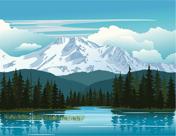
Welcome to the Great Nanhu Mountain
In this Earth Cache, there is no physical container to be found. Instead you will learn about glacier erosion, specifically things related to how glaciers "recently" reshaped this mountain and its surrounding areas like glacial lakes, glacial erratics and glacial cirques .
There used to be debate for a long time in Taiwan about whether glaciers ever did make their presence known in the high mountains of Taiwan. To see how an end was put to this “heated” debate and close the books on the doubting minds, let us take a look at what a team of Japanese, Taiwanese and German geologists did and the evidence they provided to prove that the forces of Mother Nature did in fact come upon the high mountains of Taiwan glacial erosion style here at the Great Nanhu Mountain. And while we get our glaciology on, we are going to go a step further and find that lake of old (which will be explained in more detail in the first section below). Upon learning about all the research that went into proving the existence of glaciers here at the Great Nanhu Mountain, we are going to put our glaciological knowledge to the test out in the field and make observations and come to conclusions based on those observations to show forth our glaciologist persona. After you complete the tasks and answer the questions (which can be found at the bottom of this page), you can log a "Found It!" on this Earth Cache. I hope you enjoy! Let's begin the fun!
|
Introduction to the Great Nanhu Mountain:
南湖大山 — romanized as Nanhu Mountain — is the highest peak of the northernmost section of the Central Mountain Range here in Taiwan. This mountain was once made by the convergence and subduction of the Eurasia Plate and the Philippine Plate millions of years ago. However, according to a team of German geologists, it has only “recently” (say 20,000 years or so) been reshaped by glaciers as is evidenced by the presence of the famous Nanhu Cirque (Waypoints 5 & 6), and glacial erratics (Posted Coordinates) near the peak.
Furthermore, there were observations made by the team of geologists that determined various rock material could not have been transported by water alone but rather ice, thus proving the existence of glaciers upon this mountain at one time.
We shall get into more of the Earth Science aspect the topic momentarily but one thing of interest that will be the entire focus of this Earth Cache is the name of this mountain — Nanhu Mountain —, which if literally translated, means “The Great Mountain of the Southern Lake”, but as any one who has been here or who will go here all know, there is no such lake near this mountain. So why such a name? Why is the word “lake” (湖) even in the name of this mountain when it appears that no such landform is near this mountain? One idea is the name is actually a misnomer as mountaineers were tricked into believing something they thought they saw. Because of the sun shining brightly upon the gravel near Nanhu Mountain, mountaineers thought what they saw was a lake but in actuality it was more of a mirage-type image. However, this illusion stuck and thus gave Nanhu Mountain Her name, and continues to be named such to this day.
But what if the “mislabeled” landform here actually did (or does) exist? I mean, what if what explorers to this mountain many, many years ago actually saw was a glimpse into the past of what used to be here — a lake? What if Nanhu Mountain isn’t incorrectly named but actually holds the key to its past and we could see what this “Southern Lake” used to look like?
Let us delve into the research of that team of geologists mentioned above and understand exactly the geological uniqueness of this area here in Taiwan. Let us go on a journey deep into the Central Mountain Range of Taiwan and look deep into the glacier erosion history of this one-of-a-kind mountain and find that lost lake. (Waypoints 5 & 6 + Posted Coordinates)
|
In order to understand the rich geological history of this area and to find that lost lake, it is first necessary to get a picture of glacial erosion as a whole, especially in regards to glacial cirques and glacial erratics.
|
Introduction to the Glaciers and How They Sculpt The Land
First, let us find out what a glacier is exactly :
What is a Glacier?
Glaciers are found in very cold regions. In simple terms, a glacier is moving ice. This means the availability of snow and some slopes are conditions for glaciers to occur.
Let's look at the illustration below:

1 — Glacier begins with lots and lots of snowfall, in regions where the ice rarely melts. They fall on mountain slopes and over weathered rock material.
2 — After many years of repeated snowfalls, the ice is compressed under its own weight. The compressed snow and ice become heavier with even more snowfall.
3 — Sometimes, the land warms up and melts a thin layer of the rock surface and the solid ice and snow. This causes the ice to slide and crush under its own weight. As they move along the mountain slope, they break off rocks on the surface (abrasion) and carry them downhill.
4 — When the ice melts, they rocks, sand, clay and all the debris are left behind to form a moraine. In very cold climates, the ice never melts, even after the move downhill. Sometimes they end up in the seas and float on the water surface.
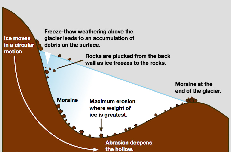
Now that we understand the basics behind glaciers, let's look briefly look at how glaciers erode the land.
When gravity causes ice to move down the side of a mountain there are two ways in which the rock below is eroded. These are plucking and abrasion.
Plucking occurs when rocks and stones become frozen to the base or sides of the glacier and are plucked from the ground or rock face as the glacier moves. This leaves behind a jagged landscape. This causes the wearing away of the landscape as the glacier behaves like sandpaper.
Abrasion occurs when rocks and stones become embedded in the base and sides of the glacier. These are then rubbed against the bedrock (at the bottom of the glacier) and rock faces (at the sides of the glacier) as the glacier moves.
Below is an illustration to help visualize what's going on:

So from the illustration above we can see how the glacier wears away the landscape. And like mentioned above, because the glacier acts like sandpaper, it leaves behind smooth polished surfaces which may have scratches in them and these scratches are known as striations and these striations are carved out by angular debris embedded in the base of the glacier.
|
Now that we have gone over glaciers and how they sculpt the land, now it is time to get into the main event here — The Great Nanhu Mountain — and the glacial landscapes that are preserved upon this geological gem.
|
The Great Nanhu Mountain — The Area with the Best Preserved Glacial Landforms
As stated in the very beginning of this Earth Cache, a team of geologists from Germany, Japan and Taiwan have worked endlessly studying the high mountains of Taiwan, in particular The Great Nanhu Mountain here in Central Taiwan. Because of their decades of studies, we can now know that glaciers did in fact form on the high mountains in Taiwan, and according to two geologists from Japan, [The Great Nanhu Mountain] is the area with the best preserved glacial landforms.
Let us look into their research and see how they reshaped our thinking of this great island nation.
The Great Nanhu Mountain consists of three kinds of rocks:

. . . and all of these rocks have been subject to frost weathering, which is when water freezes into ice and then erodes the land.
This was especially significant to the geologists as they were able to determine that the material above the rock barriers around this peak could not have been transported by water alone since there was just not enough "hydraulic" action, or more aptly put, not enough fluvial action since the rivers do not carry enough force of water to "destroy" the material and then move it. Therefore, rock debris could have only been relocated because of frost weathering or ice freezing the rocks and then plucking away at them when thawing.
Another unique aspect of The Great Nanhu Mountain, is the presence of erratics or rocks that are geologically different from other rocks in the area. In other words, an erratic is a rock of any size that looks very different from all other rocks nearby. Also, erratics are easily identified by their striations or streaks along their surface. It has been noted that there are both rock and boulder size erratics here at the Great Nanhu Mountain.
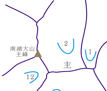
One last thing that the researchers/geologists discovered in this area that was the icing on the cake in proving the existence of glaciers is the presence of a dozen cirques. You can see in the diagram below the location of the cirques here at the Great Nanhu Mountain:

From the image above we can see the abundance of cirques around this mountain. A cirque a bowl-shaped valley that came about because of glaciers eroding the land. As the ice melts and thaws, it progressively moves downhill and more rock material is scoured out from the cirque creating the characteristic bowl shape. Many cirques are so scoured that a lake forms in the base of the cirque once the ice has melted.
Below is one last diagram of common landforms including the ones we talked about in this Earth Cache. Please note the location of the tarn, which is a glacial lake.

|
Now that we have learned about the gem of glacier goodies that the Great Nanhu Mountain provides, now it is time for the real star of the show — that lost lake.
|
Glacier Lakes around the Great Nanhu Mountain
As stated earlier, The Great Nanhu Mountain can be literally translated as “The Great Mountain of the Southern Lake”,, which was labeled as an incorrect name since there is no such lake. However, no correction to the name has ever been made so it is of great interest to find that lake that bears its name in this mountain, especially because of the abundance of glacier activity here and how this mountain has been deemed the best place to experience the preserved state of these landforms.
To find where this lake is, we must first understand how a glacier lake is formed. As seen in the diagram below, such lake can be identified by quite a few names but the way it is formed is quite easy to understand. Glacial lakes typically form at the foot of a glacier. As glaciers move and flow, they erode the soil and sediment around them, leaving depressions and grooves on the land. Meltwater from the glacier fills up the hole, making a lake.
Now, the "Great Mountain of the Southern Lake, with emphasis on the Southern Lake, should be located where number 2 is on the cirque illustration below:
So where is the lake? Is it really there? Or is it just a figment of our imagination? Could it have really existed or is the name of this mountain indeed a misnomer? I guess we will have to put on our thinking caps for this one look closely at any signs of lack thereof of discoloration along the sides of the mountains indicating that there was once water here or maybe the area around cirque 2 is a "dry lake"? I guess it is time to get our exploration on and come out to this gem of wonder high in the mountains of Taiwan and find out for ourselves. What do you say? Are you ready?
|
Logging Requirements:
The Great Nanhu Mountain is definitely a one-of-a-kind geological wonder carved by glaciers here in Taiwan, and at the Posted Coordinates as well as the two Referenced Waypoint (WP 05 & 06) you will see the unique landforms that were shaped by the forces of Mother Nature, and at the same time, get a glimpse into this mountain's rich geological history, not only from the perspective of millions of years ago but also from a more "recent" period — "20,000 years ago" when glaciers came and visited this land. And while we take in the beauty that is Mother Nature, let us propel ourselves into a whole new dimension and find that lost lake that bears its name here at the highest peak of the northern section of the Central Mountain Range — The Great Nanhu Mountain.
In order to log a Found It! for this Earth Cache, please go to the Posted Coordinates and the two additional Referenced Waypoints (WP 05 & 06) to complete the following tasks:
1. On your way to The Great Nanhu Mountain, you will first come to Waypoint 5 where you will be looking down from on high at the glacier cirque below (which is labeled 2 in that illustration above in the Glacier Lakes around the Great Nanhu Mountain section). Based on what you have learned about glaciers themselves and glacier cirques, in what direction do you believe the glacier flowed and then retreated to create the glacial cirque you are viewing from above? How did you come to this conclusion?
2. As you travel down from Waypoint 05 into the the glacier cirque itself, pay attention to the descent and the rocks below you, particularly the angle of descent and the "looseness" or "tightness" of the rocks you are walking on. Based on your knowledge of glaciers and your initial observations of which direction you believed the glacier flowed in and then retreated, what defining features of this descent prove that the researches were right in their conclusion that glaciers were indeed present upon this mountain and how this mountain has "the best preserved glacial landforms"?
3. After you make it to Waypoint 6, which is the actual glacial cirque itself, walk around this area. Pay attention to any depressions in the land and the rocks located within as well as the overall flatness of the area. Based on what you have learned about glacial cirques and based on your observations and "experiencing" of the glacial cirque here at Waypoint 6 what would you estimate the "length" of the glacier to be before it started to retreat? In other words, how long is the "flatness" of the glacial cirque? What about its length? How were you able to come up with these figures?
4. Based on your observations at Waypoint 6 from Task 3., and based on what you have learned about glacial lakes, what defining features could you observe here that would "prove" the actual existence of a lake at one one time? How were you able to come to this conclusion?
5. As you travel onwards to the Posted Coordinates (which is the actual peak of The Great Nanhu Mountain), pay attention to the rocks you pass. As you near the peak, you will cross over a group of huge boulders. Based on what you have learned about glacial erratics and based on your observations of the ascent up from the glacial cirque to the peak, would you say that the rocks (or boulders) you passed were in fact erratics? How did you come to your conclusion?
6. At the Posted Coordinates you will be able to view one last piece of "evidence" that proves the existence of glaciers. Based on what you have learned about glaciers and the particular landforms they create, reference the various charts that have been provided in this Earth Cache listing. What defining feature is present here at the peak that is the "icing on the cake" and provides the last piece of evidence to prove that the researchers/geologists were right in their assessment of this area? How were you able to come to your conclusion?
7. Optional— Post a photo of yourself or a "Geocaching" item identifying yourself near a landform or other place where there is evidence of glacial erosion.
You may log a Found It! on this cache after you have completed the tasks and emailed me the answers. If there are any issues with your answers, I will contact you. And as a friendly reminder, please do not post any of the answers in your logs. Thank you for visiting this Earth Cache. I hope you enjoy your time on The Great Nanhu Mountain!