
La Earhcache / The Earhcache
► Contexte géologique local
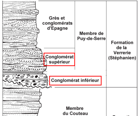
La tranchée de chemin de fer de la Cité (ou de la Verrerie) coupe en oblique des formations du flanc Sud du synclinal houiller de la Verrerie (Bassin de Faymoreau).

Cet ensemble du Stéphanien se caractérise par une succession de couches conglomératiques.
► Les formations conglomératiques de la Cité
C'est à la fin du Carbonifère Supérieur, à l'étage du Stéphanien (-305 Ma) que se met en place la formation de la Cité (datation par fossiles stratigraphique se trouvant dans la faisceau de la Verrerie).
Elle se caractérise par deux formations conglomératiques sédimentaires fruits de la dynamique d’un bassin intracontinental en domaine orogénique.
Un conglomérat en géologie est une roche détritique (issue de la dégradation mécanique d'autres roches) composée de morceaux discernables (>2 mm) liés entre eux par un ciment naturel.
Parmi les conglomérats, on distingue :
- les brèches, composées de blocs anguleux ou polygéniques d'origine gravitaire ou glaciaire.
- les poudingues, composés de galets aux formes arrondies d'origine fluviale.
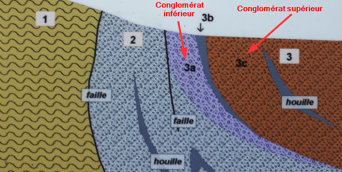
~ Le "Conglomérat Inférieur", formation gravitaire
La base de la formation de la Cité est le Conglomérat Inférieur, ou Conglomérat Rouge de la Verrerie, présentant une puissance d'environ 100 m et revêtant un caractère spectaculaire.
Il est formé de gros éléments pluridécimétriques représentant principalement des dépôts gravitaires de type coulée de débris à éléments polygéniques fortement hétérométriques (de 2 à 80 cm).
Ces gros blocs peu usés, rubéfiés et lithologiquement très différents impliquent des sources variées et géographiquement proches : quartzite rouge de Champdeniers, schistes de Puyhardy, grauwackes et schistes de Roc-Cervelle et de Marillet.

Cette formation sédimentaire est de type cône alluvial proximal.
L’absence de litage, l’hétérométrie et la présence de granoclassement inverse à la base des bancs indiquent une mise en place par coulées de débris et des trajets de transports courts.
~ Le "Conglomérat Supérieur", formation fluviale
Après une interruption de la sédimentation et la mise en place d'une forêt tropical à l'origine du Faisceau houiller de la Verrerie, l'altération des formations montagneuses reprend, mais cette fois dans un cadre fluviale.
Il en résulte une formation de niveaux conglomératiques beaucoup moins grossiers que ceux du « Conglomérat inférieur », sous la forme de figures de chenaux métriques à décamétriques.
Ce sont surtout des poudingues à petits galets bien classés, d’une taille de l’ordre de 2 à 7 cm.
Les galets de quartz blanc rubéfiés y sont majoritaires (80%) mais on trouve aussi des galets de phtanite et de quartz noir (15%), d’ignimbrites, de grauwackes et de gneiss (5%).

Ces caractéristiques indiquent que la sédimentation a été de type cône alluvial distal en rapport avec un élargissement du bassin (aire d’alimentation plus étendue avec la présence des galets d'ignimbrites, phtanites et gneiss).
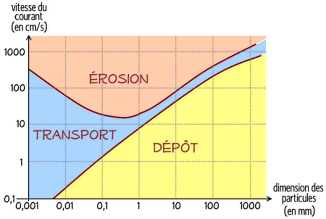
Ce conglomérat étant fluviatile, il est possible de déterminer ses conditions de formation (vitesse du courant et régime fluvial) grâce au diagramme de Hjulström.
► Le Synclinal de la Verrerie
Ces formations sédimentaires sont à l'origine sub-horizontales (formation de dépôts de pente suite une érosion en domaine orogénique), selon le principe de superposition stratigraphique.
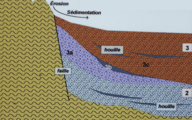
Ces dépots ont ensuite subi des mouvements tectoniques postérieurs à l'origine d'un synclinal cylindrique isopaque, le Synclinal de la Verrerie.
Cette compression résulte des derniers serrages de la chaîne varisque au niveau du Domaine Sud-armoricain.
La mise en place de ce synclinal s'est accompagné du redressement des formations en présence, d'autant plus important qu'on s'approche du bord de ce synclinal.
Au niveau de la coupe de la Cité (parties bordurières du Synclinal de la Verrerie), les formations initialement superposées horizontalement se sont redressées quasi-verticalement, amenant côte à côte les deux formations d'âge bien différent.
► Local geological context
The Cité (or La Verrerie) railway trench cuts obliquely between the formations on the southern flank of the La Verrerie coal syncline (Faymoreau Basin).
This set of Stéphanien is characterized by a succession of conglomerate layers.
► The conglomerate formations of the City
It is at the end of the Upper Carboniferous, at the stage of the Stéphanien (-305 Ma) that the formation of the City takes place (dating by stratigraphic fossils found in the beam of the Glassworks).
It is characterized by two conglomerate sedimentary formations resulting from the dynamics of an intracontinental basin in the orogenic domain.
A conglomerate in geology is a detrital rock (resulting from the mechanical degradation of other rocks) composed of discernible pieces (> 2 mm) linked together by a natural cement. Among the conglomerates, we can distinguish:
- breaches, made up of angular or polygenic blocks of gravity or glacial origin.
- pudding, composed of rounded shaped pebbles of river origin.
~ The "Lower Conglomerate", gravity formation
The base of the formation of the City is the Lower Conglomerate, or Red Conglomerate of the Glassworks, presenting a power of about 100 m and taking on a spectacular character.
It is made up of large multi-decimetric elements mainly representing gravity-type deposits of debris flow with highly heterometric polygenic elements (from 2 to 80 cm).
These large, little worn, rubefied and lithologically very different blocks involve varied and geographically close sources: red quartzite from Champdeniers, schists from Puyhardy, grauwackes and schists from Roc-Cervelle and Marillet.
This sedimentary formation is of the proximal alluvial cone type.
The absence of bedding, heterometry and the presence of reverse grading at the base of the beds indicate placement by debris flows and short transport routes.
~ The "Superior Conglomerate", river formation
After an interruption of the sedimentation and the establishment of a tropical forest at the origin of the coal beam of the Verrerie, the alteration of the mountainous formations resumes, but this time in a river setting.
This results in the formation of conglomerate levels much less coarse than those of the “Lower Conglomerate”, in the form of metric to decametric channel figures.
They are mostly pudding with small, well-graded pebbles, about 2 to 7 cm in size.
Rubefied white quartz pebbles are the majority (80%) but there are also pebbles of phtanite and black quartz (15%), ignimbrites, grauwackes and gneiss (5%).
These characteristics indicate that the sedimentation was of the distal alluvial cone type in relation to an enlargement of the basin (more extensive feeding area with the presence of ignimbrite, phtanite and gneiss pebbles).
As this conglomerate is fluvial, it is possible to determine its formation conditions (current speed and fluvial regime) using the Hjulström diagram.
► The Synclinal de la Verrerie
These sedimentary formations are originally sub-horizontal (formation of slope deposits following erosion in the orogenic domain), according to the principle of stratigraphic superposition.
These deposits then underwent subsequent tectonic movements at the origin of an isopaque cylindrical syncline, the Synclinal de la Verrerie.
This compression results from the last tightening of the Variscan chain at the level of the South Armorican Domain.
The establishment of this syncline was accompanied by the recovery of the formations present, all the more important as one approaches the edge of this syncline.
At the level of the section of the Cité (bordering parts of the Synclinal de la Verrerie), the formations initially superimposed horizontally have straightened up almost vertically, bringing side by side the two formations of very different ages.
► Sources bibliographiques / Bibliographical sources
Les Questions / The Questions
Questions pour valider :"Conglomérats et Synclinal à la Cité"
Questions to validate: "Conglomerates and Synclines in the City"
- Question 0 : Prenez une photo de vous ou d'un élément vous identifiant dans la Tranchée de la Cité, mais pas aux WPs.
Cette photo devra au choix nous être transmise avec les réponses ou être ajoutée à votre log.
-Question 0 : - Take a photo of yourself or something that identifies you in the Tranchée de la Cité, but not at the WPs.
This photo must either be sent to us with the answers or added to your log.
Point 1 : N 46° 33.326 W 000° 38.594
En venant du parking, vous suivez la tranchée de l'ancienne voie de chemin de fer de la Cité jusqu'au WP1 ou vous pouvez observer un affleurement conglomératique sur votre droite.
Coming from the car park, you follow the trench of the old Cité railway line to WP1 where you can observe a conglomerate outcrop on your right.
- Question 1 : Observez l'affleurement et décrivez cette roche. Notez vous une orientation des dépôts ? Déduisez-en s'il s'agit d'un dépôt gravitaire ou fluviale, en justifiant votre réponse.
- Question 1: Observe the outcrop and describe this rock. Do you note the orientation of the deposits? Deduce whether it is a gravity or fluvial deposit, justifying your answer.
- Question 2 : En fonction de votre réponse à la question précédente, déterminer les conditions de formation de ce conglomérat en utilisant le diagramme du descriptif.
- Question 2: Depending on your answer to the previous question, qualify the conditions for forming this conglomerate using the diagram in the description.
- Question 3 : Déduisez-en la nature de la formation conglomératique du WP1. En fonction des formes des clastes la constituant, comment s'appelle ce type de conglomérat ?
- Question 3 : Deduce the nature of the conglomerate formation of WP1. Depending on the forms of the clasts constituting it, what is this type of conglomerate called?
- Question 4 : Relevez l'altitude du WP1 avant de poursuivre votre chemin vers le WP2.
- Question 4 : Read the altitude of WP1 before continuing your way to WP2.
Point 2 : N 46° 33.220 W 000° 38.478
Vous voici au niveau d'un vaste affleurement avec un panneau d'information à ses pieds.
Nous ne nous intéresserons pas au panneau, uniquement à l'affleurement, mais sa lecture donne des informations complémentaires sur la géologie de la Coupe de la Cité.
Here you are at a large outcrop with an information panel at its feet.
We will not be interested in the panel, only the outcrop, but reading it gives additional information on the geology of the Coupe de la Cité.
- Question 5 : Observez l'affleurement et décrivez cette roche. Notez vous une orientation des dépôts ? Déduisez-en s'il s'agit d'un dépôt gravitaire ou fluviale, en justifiant votre réponse.
- Question 5: Observe the outcrop and describe this rock. Do you note the orientation of the deposits? Deduce whether it is a gravity or fluvial deposit, justifying your answer.
- Question 6 : Approchez vous de la falaise et regardez les plus gros éléments. Décrivez leur taille, leur forme, leur nature. Ces différentes caractéristiques sont-elles homogènes ? Cela conforte t-il votre réponse à la question 1 ? Déduisez-en la nature de la formation conglomératique du WP2.
- Question 6 : Approach the cliff and look at the larger elements. Describe their size, shape, nature. Are these different characteristics homogeneous? Does this support your answer to question 1? Deduce the nature of the conglomerate formation of WP2.
- Question 7 : Prenez l'altitude au WP2 et comparer le à celle du WP1. En considérant la coupe stratigraphique de la région et vos observations précédentes cette différence d'altitude est-elle normale en géologie ? Comment est-on arrivé à cette configuration ?
- Question 7 : Take the altitude at WP2 and compare it to that of WP1. Considering the stratigraphic section of the region and your previous observations, is this difference in altitude normal in geology? How did we arrive at this configuration?
Vous pouvez vous loguer sans attendre notre confirmation,
mais vous devez nous envoyer les réponses par mail en même temps via notre profil (
fafahakkai).
S'il y a des problèmes avec vos réponses nous vous en ferons part.
Les logs enregistrés sans réponses seront supprimés.You can log this cache without waiting for our confirmation, but you must send us the answers by e-mail at the same time via our profile (fafahakkai).
If there is a problem with your answers we will notify you. The logs recorded without answers will be deleted.
Rappel concernant les « Earthcaches »: Il n'y a pas de conteneur à rechercher ni de logbook à renseigner. Il suffit de se rendre sur les lieux, de répondre aux questions ci-dessus et de nous renvoyer les réponses.
Reminder concerning "Earthcaches": there is neither a container to look for nor a logbook to sign. One need only go to the location, answer to the differents quiestions and send us the answers.