
Rendez-vous au Waypoint, vous surplombez l'Endre, un cours d’eau qui prend sa source à Tourrettes et finit par se jeter dans le fleuve Argens au niveau de la commune du Muy.
L'été, il peut être à peine visible en période de fortes chaleurs et être, après des séries de précipitations intenses, un torrent pouvant faire des dégâts sur son passage.
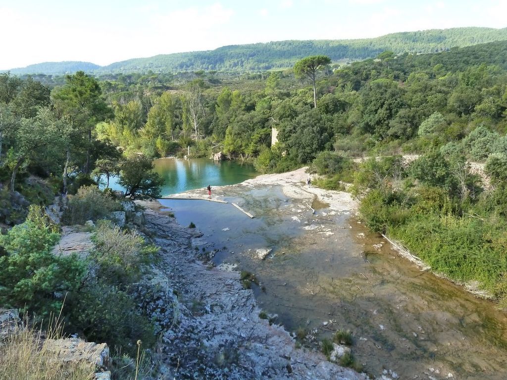
L’Endre s'étendant sur environ 28 km, il traverse la Provence Calcaire (tête de bassin versant, au nord-ouest de ce dernier) et la Provence Cristalline (au sud et à l’est du bassin versant).
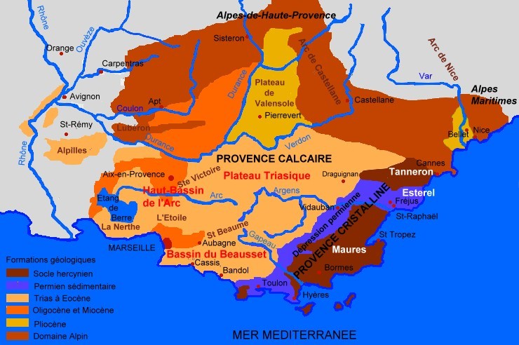
La Provence Calcaire est caractérisée, comme son nom l'indique, par une prédominance de calcaire, roche principalement de couleur blanche.
Les roches calcaires, formant la plupart des massifs de Provence Calcaire, proviennent des sédiments marins déposés lorsque que la mer recouvrée la Région. On les appelle donc roches sédimentaires.
La Provence Cristalline est formée principalement de granites et de schistes cristallins.
Ce sont des roches métamorphiques, c’est-à-dire des roches transformées (donc qui ont subi une métamorphose) sous l’effet de fortes températures ou ayant subi une pression élevée, les roches métamorphiques peuvent notamment se former lors d’éruptions volcaniques. Ces roches contiennent souvent des cristaux visibles à l’œil nu d’où le terme « Cristalline ».
Parmi les roches composant la Provence Cristalline on trouve la rhyolite amarante et sa couleur rouge caractéristique.
Les rhyolites sont des roches issues du refroidissement du magma, en effet la Région a connu une importante activité volcanique, la rhyolite amarante est emblématique du massif de l'Esterel, qui fût formé lors de divers éruptions volcaniques, principalement il y a 280 à 250 Millions d’années.
Votre mission
Pour se conformer aux nouvelles directives éducatives pour les Earthcaches vous devez répondre aux questions suivantes :
Question 1 : Quelles sont les différences entre la Provence Calcaire et la Provence Cristaline ? Expliquez notament pourquoi on parle de roches sédimentaires et roches métamorphiques.
Question 2 : Qu'est-ce qui sépare géographiquement ces deux zones (voir carte) ?
Question 3 : De là où vous êtes vous pouvez observer de nombreux débris rocheux charriés et polis par le cours d'eau, decrivez-les (couleurs, lisses ou alvéolés, les différentes tailles que vous observez) ?
Question 4 : Certains des plus gros débris présentent une couleur caractéristique des massifs géologiques locaux tel l'Esterel, de quelle couleur s'agit-il ?
Question 5 : Quelle est cette roche ? Est-elle rattachée de la Provence Calcaire ou de la Provence Cristalline ?
Loguez cette cache "Found it" et envoyez-moi vos propositions de réponses soit via mon profil, soit via la messagerie geocaching.com (Message Center), et je vous contacterai en cas de problème.
Toutes les photos, ne donnant pas d’indices, seront fortement appréciées.

Go to the Waypoint, you overlook the Endre, a river that takes its source in Tourrettes and ends up in the river Argens at the level of the commune of Muy.
In the summer, it can be barely visible during hot weather and, after a series of intense rainfalls, can be a torrent that can cause damage in its path.
L'Endre extends for about 28 km, it crosses Provence Calcaire (head of watershed, north-west of the latter) and Provence Cristalline (south and east of the watershed).
The Provence Calcaire is characterized, as its name indicates, by a predominance of limestone, rock mainly of white color.
The limestone rocks, forming most of the massifs of Provence Calcaire, come from the marine sediments deposited when the sea covered the Region. They are therefore called sedimentary rocks.
The Provence Cristalline is formed mainly of granite and crystalline schists.
These are metamorphic rocks, that is to say transformed rocks (which have undergone a metamorphosis) under the effect of high temperatures or having undergone a high pressure, metamorphic rocks can form in particular during volcanic eruptions. These rocks often contain crystals visible to the naked eye, hence the term “Crystalline”.
Among the rocks that make up Provence Cristalline are the Amaranth rhyolite and its characteristic red colour.
The rhyolites are rocks resulting from the cooling of the magma, indeed the Region has known a significant volcanic activity, the amaranth rhyolite is emblematic of the Esterel massif, which was formed during various volcanic eruptions, mainly there are 280 to 250 Million.
Your mission :
To comply with the new educational guidelines for Earthcaches you must answer the following questions:
Question 1: What are the differences between Limestone Provence and Cristaline Provence? Explain in particular why we are talking about sedimentary and metamorphic rocks.
Question 2: What geographically separates these two areas (see map)?
Question 3: From where you are you can observe many rock debris loaded and polished by the stream, describe them (colors, smooth or honeycomb, the different sizes you observe)?
Question 4: Some of the larger debris have a characteristic colour of local geological massifs such as Esterel, what colour is it?
Question 5: What is this rock? Does it belong to Provence Calcaire or Provence Cristalline?
Log this "Found it" cache and send me your response proposals either via my profile or via the geocaching.com (Message Center) messaging service, and I will contact you if you have any problems.
All photos, not giving clues, will be highly appreciated.